![]()
![]()
|
|
|
Below are the complete Cruising Notes published in Zihuatanejo. It is a document of 113 pages, published as a Word document and as an HTML file. S/V “SIESTA” Edited Notes on
Central America, Ecuador, the Galapagos, and the Western Caribbean January 18, 2003
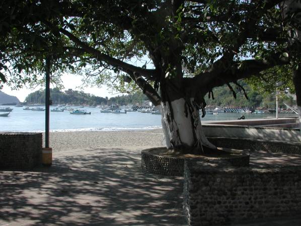
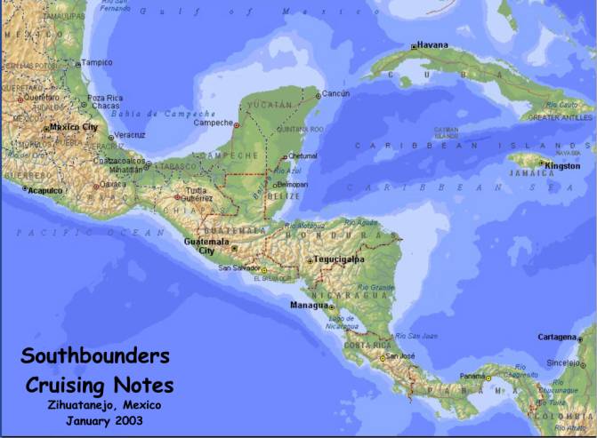
Zihuatanejo,
Mexico – January 2003 1. Introduction from the Editors IMPORTANT!
READ CAREFULLY! None of the contributors
to this compilation of cruising notes, nor its editors, assume any
responsibility for the accuracy of the information. USE THIS INFORMATION AT YOUR
OWN RISK! We hope you find these notes useful as you head south from
Zihuatanejo. We have compiled the information in these notes from many sources.
Virtually all the material comes from letters and emails from cruisers who have
recently explored the Pacific Central American and Western Caribbean waters.
Some also contributed their experiences in Ecuador and the Galapagos Islands, as
well. The idea for these compiled notes came to us as we sat here
at anchor in beautiful Zihuatanejo Bay, aboard ¨SIESTA” (our CSY 44
center-cockpit cutter), preparing for our trip south to the Panamá Canal and on
to our home in the Florida Keys. We felt we needed current information.
Conditions can change quickly in these waters.
We wanted access to fresh, recent information from other cruisers like
us, to supplement the many excellent cruising guides that already exist. And we
wanted this information organized in such a way that it could be referenced
easily. Yet we wanted to do a minimum of editing, to keep the scope of work
manageable to a reasonable period of time. We give our thanks to the many cruisers who have contributed
to these notes. For example, Anne, from the ketch MICHAELANNE, came on the VHF
in Zihuatanejo and offered her own cruising notes and those of other
Southbounders she had compiled on diskette. Other cruisers currently in Central
America were contacted via email and immediately started sending very useful
information about places they visited. And we already had a file of cruising
notes of our own, received from many cruising friends and owners of other CSY
44’s. We are particularly grateful to Don and Gwen on TACKLESS II, and Dave
and Stacey on SOGGY PAWS for their many detailed cruising notes. But there are
many, many others. So thanks to all of you, you know who you are, and your names
all all over these notes, using as much detail as we could find! The emails, logs and letters included in these edited notes
in many cases were not meant to be included in a cruising
“guide” type of format. We have done very little, if any, editing on
these letters. As such, they include a number of illustrative, anecdotal,
sometimes even quasi-personal observations, that we feel best colors and
exemplify the best of the cruising life. As
a result, you will find very different styles and types of information
intertwined into a cruiser’s “patch quilt”. We hope that all these genuine
stories and sketches will help you get into the frame of mind of a cruiser about
to enter the beautiful waters of Pacific Central America and the Western
Caribbean. We also found some other excellent sources on Central
America, which we recommend reading. In the spring of last year, 2002, the
Southbounders in Puerto Vallarta put together an excellent set of cruising
notes, and published them as the SOUTHBOUND CRUISERS RESOURCE DIRECTORY
2002/2003, on both paper and CDROM media. Rick
offered us a copy from Rick’s Bar’s files. We have added this document to
the Zihuatanejo CDROM as well. Also, Walt made available his file of paper
documents kept at the Zihuatanejo Yacht Club, from previous Zihuatanejo
Southbounders. We selectively copied small portions of these paper documents for
our own use, but could not include this information, since the text was not in
machine-readable form, and could not easily be added to the CDROM. We welcome comments and future articles and emails from the
readers of these notes. We will publish what we receive on our web site, along
with these original notes, to enable future Southbounders to benefit from your
new experiences and adventures. We wish fair winds and following seas to all the
Southbounders from Zihuatanejo! ¡Qué
tengan todos una aventura maravillosa por Centro America! Ed and Daisy Marill Zihuatanejo, Mexico January 18, 2003 These cruising notes
were made available to cruisers in Zihuatanejo, in CDROM media form, both as a
Microsoft Word document, and as an HTML file, viewable by any web browser,
without the need for Microsoft Word. These notes were distributed via CDROM
during the 2003 Zihua Sailfest Event, for the modest contribution of $10US to
benefit the local Indian school. Printed copies of this CDROM were not made
available, although they could easily be produced from the CDROM. Copies of this
disk will be left at Rick’s Bar and at the Zihuatanejo Yacht Club, for the use
of future Southbounders who come here to prepare for the journey south. 2. TABLE OF CONTENTS
1. Introduction
from the Editors
3.
The Zihuatanejo "Southbounders" Class of 2003
4.
General comments about cruising Central America:
4.1
From Slainte (Allan and Liz, 2002)
4.2
From John and Anne aboard the Morgan OI 41’ Chula Mula, summer, 2002)
5.1
From Anne and Michael aboard the Whitby 42’ ketch MICHAELANNE (2002):
5.2
From Gwen and Don on the CSY 44 cutter TACKLESS II,
Spring 2002:
6.
Notes on Weather in Central America:
6.1
Weather Wisdom from Don, of s/v SUMMER PASSAGE
7.
General Information about Central America:
7.1
Hauling Out in Panamá – Pacific Side - from SUN DAZZLER, Spring, 2002
7.2
Hauling Information from s/v SLAINTE (2002):
7.3
Other General Information (from Michael and Anne aboard MICHAELANNE, Spring
2002):
8.
Notes on Zihuatanejo to Mexico Border:
8.1
Acapulco report from Mark aboard TONDELAYO on 1/3/2003:
8.2
Acapulco report from Jutta and Ferdy aboard the Endeavour 40 PIPE DREAM, Spring
2002:
8.3
From Jim and Suzy aboard s/v SPARTA, Fall
2002:
8.4
Anchorages around Huatulco, Mexico, from Gwen and Don on the CSY 44 cutter
TACKLESS II, 2002:
8.6
From Jim and Suzy aboard s/v SPARTA, Fall
2002:
9.
Notes on Mexican Border to Guatemala:
9.1
From Diane on WINBIRD, from Bahia del Sol, in El Salvador, Jan 1, 2003:
9.2
From Jutta and Ferdy aboard the Endeavour 40’ Pipe Dream, Spring 2002:
10.1
From Michael and Anne aboard the Whitby 42’ ketch MICHAEL ANNE, spring 2002:
10.2
From John and Anne aboard the Morgan 41 OI CHULA MULA, August 2002:
10.3
From Jutta and Ferdy aboard PIPE DREAM, Spring 2002:
10.4
From Diane on WINDBIRD, from Bahia del Sol in El Salvador (2003):
10.5
From Matt aboard ELSEWHERE, received in Zihuatanejo via Winlink on January 1,
2003:
10.6
From John and Anne aboard the Morgan OI 41’ CHULA MULA,
Spring 2002:
10.7
From MICHAELANNE and TACKLESS II:
10.8
From Jim and Suzy aboard s/v SPARTA, Fall
2002:
10.9
s/v RAGTIME--January, 2002
11.1
From Gwen and Don on the CSY 44 cutter TACKLESS II,
2002:
11.2
From Michael and Anne aboard the Whitby 42’ ketch MICHAELANNE—April, 2002
11.4
From Jim and Suzy aboard s/v SPARTA,
Fall 2002:
12.1
From Michael and Anne aboard the Whitby 42 ketch MICHAELANNE, Spring 2002:
12.2
From Allan and Liz aboard SLAINTE, 2002:
12.3
From Greg and Meg aboard the motoryacht WET
BAR, December 2002:
12.4
From Pete aboard s/y NEENER 3-- June, 2002
12.5
From Gwen and Don on the CSY 44 cutter TACKLESS II,
2002:
12.6
From Jutta and Ferdy aboard PIPE DREAM, Spring 2002:
12.7
From Jim and Suzy aboard s/v SPARTA,
Fall 2002:
13.
Notes on Pacific Coast of Panama:
13.1
From Gwen and Don on the CSY 44 cutter TACKLESS II,
2002:
13.2
s/y RAGTIME--February, 2002
13.3
s/y AKAUAHELO--June, 2002
13.4
From Tom and Kathy on the s/y TAI-TAM--spring and summer, 2002
13.5
Three Anchorages on the Way to Punta Mala, Panama—from Tai-Tam
13.6
From John and Anne aboard the Morgan OI 41’ CHULA MULA:
13.7
From Gwen and Don on the CSY 44 cutter TACKLESS II,
2002:
13.8
From Jim and Suzy aboard s/v SPARTA, Fall
2002:
13.9
From Beverly and Paul on the 40’ Manta Cat TOUCH’N GO (February 2002):
14.
Notes on Transiting the Panama Canal:
14.2
From Greg and Meg aboard the motorboat WET BAR, December 2002
14.3
Tai-Tam on Preparing to Transit the Canal
14.4
From Brent and Susan on the s/y AKAUAHUELO--July, 2002:
14.5
s/y NEENER 3--Summer, 2002
14.6
From Katherine & Craig Briggs aboard the Amel Santorin 46 Ketch SANGARIS
(2002):
15.
Notes on Colon and Portobelo:
15.1
From Gwen and Don on the CSY 44 cutter TACKLESS II,
2002:
15.2
From Katherine & Craig Briggs aboard the Amel Santorin 46 Ketch SANGARIS
(2002):
16.
Notes on the San Blas Islands:
16.1
From Gwen and Don on the CSY 44 cutter TACKLESS II,
2002:
16.2
Dave and Stacey on the CSY 44 Cutter SOGGY
PAWS, 2002:
16.3
From John and Anne aboard the Morgan OI 41’ CHULA MULA, Spring 2002:
16.4
From Katherine & Craig Briggs aboard the Amel Santorin 46 Ketch SANGARIS,
2002:
17. Notes
on Cartagena, Colombia:
17.1
From Dave and Stacey aboard the CSY 44 cutter
SOGGY PAWS, December 2000:
17.2
From John and Anne on the Morgan OI 41’ CHULA MULA, Fall 2002:
17.3
From Katherine & Craig Briggs aboard the Amel Santorin 46 Ketch SANGARIS,
2002:
18.
North from Panama/Cartagena) to Roatan area:
18.1
Dave and Stacey on the CSY 44 Cutter SOGGY
PAWS, 2002:
19.
Notes on Roatan and Guanaja:
20.
Notes on Rio Dulce, Livingston and rest of Guatemala:
20.1
Dave and Stacey on the CSY 44 Cutter
SOGGY PAWS, 2002:
21.
Notes on The Bay of Islands, Honduras:
21.1
Dave and Stacey on the CSY 44 Cutter SOGGY
PAWS, 2002:
22.
Notes on Cancun and Cozumel, Mexico:
23.
Notes on Isla Mujeres, Mexico:
23.1
Dave and Stacey on the CSY 44 Cutter SOGGY
PAWS, 2002:
24.
Isla Mujeres to the Dry Tortugas and Key West, FL
25.1
From Katherine & Craig Briggs aboard the Amel Santorin 46 Ketch SANGARIS
(2002):
25.2
From Gwen and Don aboard the CSY 44 cutter TACKLESS II, 2002:
26.
Notes on the Galapagos Islands:
26.1
From Katherine & Craig Briggs aboard the Amel Santorin 46 Ketch SANGARIS
(2002):
26.2
From Mitch and Rise aboard s/v KOMFY, May 2001:
26.3
From Gwen and Don on the CSY 44 cutter TACKLESS II, 2002:
27.
Bibliography of Cruising Guides and Books of Interest
|
|
Boat Name |
Crew |
Boat Email |
Depart.
Date |
Destination |
|
ANNA
III (?) |
Jorgen/Judith |
uncertain |
uncertain |
|
|
Mike/Catherine |
uncertain |
Atlantic
via Horn |
||
|
CABIRI |
Joe/Jon |
April-December
03 |
uncertain |
|
|
CAROL ANN |
Barney/Rachel |
2-Jan-03 |
Florida |
|
|
CASABLANCA |
Pablo |
uncertain |
uncertain |
|
|
COMPAÑÍA |
John/Susan |
January-March |
Caribbean |
|
|
DELUSIONS |
Roddy/Nancy |
uncertain |
uncertain |
|
|
EL REGALO |
Charles/Teresa |
mid-February |
Caribbean |
|
|
EVELYN ROBERTS |
Robert |
uncertain |
uncertain |
|
|
FINE ROMANCE |
Al/Jane |
January-March |
BVI |
|
|
INDIGO |
Les/Marcia |
uncertain |
uncertain |
|
|
JABBERWOCKY |
Chris/Tom |
2-Jan-03 |
E.
Caribbean |
|
|
JOURNEY |
Curt/Becky |
mid-February |
W.
Caribbean |
|
|
KATIE
ROSE (2004) |
Bob/Judy |
next
year, 2004 |
W.
Caribbean |
|
|
MERINDA |
Don |
late
Jan - early Feb |
uncertain |
|
|
MOKISHA |
Tom |
early
February |
uncertain |
|
|
REUNION |
Dennis/Marta |
mid-January |
South
Pacific |
|
|
SANGARIS* |
Craig/Kathrine |
end
of January |
Mediterranean |
|
|
SAUCY LADY |
Winona/Roy |
early
January |
uncertain |
|
|
SEAHORSE |
Patrick/Lisa |
early
January |
Caribbean |
|
|
SERAFIN |
Dee/Linda |
end
of January |
Panama
Canal |
|
|
SIESTA |
Ed/Daisy |
mid-February |
Florida
Keys |
|
|
SILHOUETTE |
Alan/Carolyn/Brian |
uncertain |
uncertain |
|
|
SPIRIT
HEALER (2004) |
Sherm/Leslie |
next
year, 2004 |
Caribbean |
|
|
STARLIGHT EXPRESS |
Al/Betty |
2-Apr-03 |
South
Pacific |
|
|
SUITE LUXURY |
Richard/Carol |
January
7th |
W.
Caribbean |
|
|
THE GREAT ESCAPE |
Duey/Nan |
late
January |
W.
Caribbean |
|
|
TRAMONTO |
Marc |
1-Jan-03 |
South
Pacific |
|
|
VORTEX III |
Bill/Shirley |
uncertain |
uncertain |
|
|
WATERDRAGON |
Taryn/Graham |
5-Jan-03 |
Costa
Rica |
|
|
*second
time down south! |
|
|
|
|
NOTE: There were other
Southbounders, headed for Zihuatanejo and points south at the time of this
writing, who were not included in this list.
“The
rainy season is great, we used our rain catcher and showered on deck.
The rain would hang with us for 1 to 4 hours and then sun.
Mold life was enhanced and things on the boat would get fuzzy.
Vinegar and water or bleach would fix that for a day or two.
We stayed at both Del Sol and Barillas in El Salvador (just south of the
Tehuantepec). Chat with Mat on
Elsewhere as they have been in Bahia Del Sol for 8 months via the SSB,
8143 at 9 am eastern time. Barillas is a gold cage where you’re at a compound for the
wealthy and they take you to town twice a week for groceries.
Both are calm, either anchored in the river or tied to a buoy.
The bay of Fonseca was beautiful and so were the many kids.
We stayed at Conchita (sp) island. From
the Bay of Fonseca to Northern Costa Rica, in my opinion is barren.
We past the area three times as the anchorage called No
Name was
where we found the lightening. The
bay Santa Elena in CR was beautiful. From Santa Elena to Coco first place to check in is a long
day's sail. Hang above Cocos and
delay checking in, as this is the best of Costa Rica. Once south of Coco, the water clarity sucks and is very very
dirty. The advertising on Costa
Rica is overstated. Once you visit,
Nicoya, Golfito and hit Panama, slow down and enjoy their islands.
They are the best; Parida,
Seca's, Contradras and the Las Perlas. Undiscovered
and wonderful. Panama is a great place. Undiscovered
Islands, wonderful fishing and great resources.”
“We
actually left Puerto Vallarta on 4-20-2002, and with a few stops, arrived in El
Salvador on 5-9. We left El
Salvador on 5-23 and arrived in Costa Rica 5-25 and stayed until 6-27, Panama we
arrived 6-28 and stayed on the Pacific side until the last week of July and went
through the canal on 8-3. The
islands of Panama are so wonderful, don't miss the opportunity to enjoy them.
They are all within a short distance of each other and uniquely beautiful
in their own way.
We
traveled from El Salvador to and through Costa Rica with 2 other boats, Trilogy
and Good Medicine. From Costa Rica
and through the canal with Sea Loco. We
arrived in the San Blas at the end of August 2002.”
SSB Nets:
Panama Connection:
8107.0 at 1330 UTC (7:30 AM local time except Panama, 8:30 AM)
Panama-Pacific Net:
8143.0 at 1400 UTC (8:00 AM local time except Panama, 9:00 AM)
Note:
All of Central America is on CST all year round except Panama, which is
on EST. No change for daylight
savings.
Western Caribbean/Panama
Area Nets:
Central American
Breakfast Club – 7083 LSB at 1300 UTC --
Ham Net, Willie, TI8ZWW of Pacific Child, irregularly comes up to give weather.
He is very knowledgeable about this coast. He has been based in Golfito
when not cruising.
Panama Connection Net
– 8107 USB at 1330 UTC – SSB Net for both sides of Panama.
Pan Pacific Net – 8143
USB at 1400 UTC—SSB Net for Boats cruising Pacific side of Central America.
North West Caribbean Net
– 8188 USB at 1400 UTC – SSB Net for NW Caribbean
Other Nets/Eastern &
Central Caribbean:
Caribbean Emergency WX
Net – 7165 LSB at 1030 UTC – Earliest weather report, from Barbados &
Trinidad. Note:
Can’t participate without and Extra License
Alex’s Net – 8155
USB at 1130 UTC – more informal chat net by Alex of sv Albatross, usually
based in Margarita. Does a brief
but good weather report for southern Caribbean right at start.
Cruiser’s Hailing Net
– 8104 USB at 1200 UTC – Open boat to boat contact for 15 minutes, mostly
eastern Caribbean
Safety and Security Net
– 8104 USB at 1215 UTC – Slightly obsessive report monitoring theft and
security problems throughout the Caribbean.
David Jones (uses call
sign “Misstine”) Weather -- 8104 USB at 1230 UTC - Rapid fire delivery of comprehensive weather for Caribbean
and SW North Atlantic. This is the
net you have to pay $100 (or whatever is current) to be able to talk to him.
He offers the useful emergency contact service. If you wait until the
absolute end of his broadcast you can call as a non-subscriber to get info about
his service. He also has a very good website at www.caribwx.com.
David Jones Weather
Redux -- 12359 USB at 1300 UTC - David
does a second broadcast aimed at Western Caribbean.
Same deal. (Also does one on
16 megahertz.)
The
NWS HIGH SEAS FORECAST is just that; seldom any help for Central America
coastwise passages. However, I use
it twice daily as input for my forecasts. Whenever offshore winds are expected
to be less than 20 kts they do not consider it significant weather and rarely
give a forecast. Whenever there is
no mention of winds east of 090W, one may reasonably assume that coastal winds,
Nicaragua and western portion of Coast Rica will be less than 30 kts. However,
when they forecast winds of 20 kts or more, then one should double the speed to
get an idea of what it really could blow close to shore.
Their forecasted wind direction is usually reliable.
Note from the
editors:
Don, on SUMMER PASSAGE, based in Newport Beach, provides
an invaluable ongoing service to
cruisers on the Pacific Coast of Mexico and Central America. Don’s cheerful
disposition, insightful analysis, darn good weather forecasts, and easy
availability on multiple SSB and Ham Nets make him a major factor in safe
cruising on the Pacific Coast. Get acquainted with his radio schedule, and
listen to the various SSB and Ham nets for his forecast information.
Patrick and Alicia, on NASTALGIA, based in Puerto Lopez
Mateos, on the Pacific side of the Baja Peninsula, also provide an invaluable
service, by regularly transcribing and distributing Don’s weather information
via voice and email. You will find them on practically every Ham or SSB Net.
Patrick provides weather information just prior to the start of the SSB
Southbound Net every evening.
The cruising community is deeply grateful to Don, Patrick and Alicia for making our cruising life safer and much more fun! We thank you from the bottom of our hearts!
There
are 2 places to haul this side of Canal. The
better facility is next to the anchorage at Flamenco, and very nice.
Flamenco Marina runs the haulout facility; $300 in and out, $75 per
layday, excl. day in and day out. If
you haul at high tide in the early AM, there is no wind.
You can splash late on your day out also, and this is like getting two
long work days free. They charge
$10 per hour for self-service pressure wash, $16 per hr if they do it.
$10 per day for power and water. One
shower in the office was available. There are LOTS of guys to take your lines coming into
lift, and a diver goes down to guide the straps into position. We also have a cutaway forefoot, so we had to insist they
angle the forward strap back a little so it didn't slip.
Their
labourers are about $6.50 hr but we hired our own and did better. Enrique worked
for 3 days tirelessly; pressure washed & sanded hull, cleaned upper hull, 2
coats of paint, waxed hull and polished brightwork all for $100 - on a 50'
boat!!! We were very pleased;
fed him lunch and gave him lots of water and soft drinks. He gave me a huge hug
when we paid him with a tip. There is another guy, even better, Robinson, aka
Tula, but he was already working for a month elsewhere.
Enrique's Tel. No is: 620
7086. Robinson-Tula's is: 643 4566 (cellular). There was a
rumor that Marina Flamenco marks up outside labour by 10%, and we were willing
to pay that, but it did not appear on our bill.
Enrique
and Tula work quite a bit at Balboa Yacht Club yard (BYC), which has a railway
haulout, so you can look them up there in person perhaps when you check in at
the Immigration desk next door. Several
folks used the railway, but check it out first, it is about $50 per day and
about the same for the haul, but getting around the rail is very hard to do
work; but if you are only doing bottom paint and hiring workers, then maybe it
doesn't matter. At least they got
to use the BYC facility for showers.
On
the negative side, the scheduling in Flamenco is a little off, and there is
nowhere to side tie when you are waiting for the lift to pull you - we had to
hover for over an hour. That may
change as they continue construction and improve.
You
have to INSIST they use plastic on the straps on their very large 150 Ton lift;
if you don't you will end up with black marks on your hull and some boats had
chunks of bottom paint lifted off. They have carpets they can put on for your
haul out which is OK, but for splashing if they don't put any plastic on, insist
on it or use lots of trash bags or wax paper, and tape on yourself.
Costa Rica Yacht Club,
in Bahia de Coco: This is the only
place in all of Central America that we know of that can dry store your boat for
any period of time. They have a good-sized travel lift that can handle almost
any vessel. They also have a
special haul-out railway for multihulls for work on the boat, but as to dry
storage, maybe not. A catamaran was
hauled in June of 2002 for $80 per day flat fee and that included the labor to
do the painting on the bottom. For
monohulls, haul-out fees in 2002 were $10 per foot out and about $400 per month
for the average 36-42 foot boat.
ATMs:
In most Central American countries you will find only a VISA card (Plus
System) is valid for ATM cash withdrawals.
The exchange rate in El Salvador is a flat 8.75 colones to the dollar.
In October, 2002 the exchange rate in Costa Rica was about 368 colones to
the dollar and the exchange rate doesn’t seem to fluctuate as in Mexico...it
just keeps going up.
Provisioning: Liquor is
less expensive in Central America than in Mexico. Food is somewhat more expensive, closer to US prices.
Most fresh foods in El Salvador are imported from Guatemala.
Panama is lower on food prices than Costa Rica and El Salvador.
During the rainy season (June to December) you will be lucky to find
produce of any decent quality except in El Salvador or Puntarenas in Costa Rica.
There is a Free Zone in
Golfito, Costa Rica; it is called the “DEPOSITO LIBRE”.
You get your “tarjeta” at the Customs office in the free zone, a
piece of paper that permits you to shop, and it limits you to something around
$500 US...and you have to wait 24 hours before using it.
You may purchase goods there once every six months per passport from June
30 to December 24 and January 1 to June 30.
The only really good
value in this free zone is the liquor and wine. You are limited to the following liquor and wine
purchases per “tarjeta”: 12
units of hard liquor (a unit can be any size from airline type bottles to half
gallons); 24 units of wine, size of units the same as with liquor.
Everything else is TVs,
Refrigerators, Washing Machines, clothes, and the like.
Inland Travel:
El Salvador is an excellent place from which to make relatively
inexpensive trips to Guatemala, Honduras, and Nicaragua.
In Costa Rica, the best place from which to make visits to the volcanoes
and the rain forests is Puntarenas. Puntarenas
is the closest port to the capital, San Jose, only about a 2 hr. bus ride away.
If you are in Golfito and wish to travel to San Jose, you can take a
9-hour bus ride or a short airplane trip on Sansa Airlines ($60 one way as of
October, 2002).
Veterinary Services:
There is a veterinary store and consulting vet in Puntarenas.
They sometimes have Science Diet food products and kitty litter.
In Golfito, see Katie of
Land & Sea Services and she will put you in touch with Francisco, an
excellent veterinarian from Cuidad Neilly (45 minutes away) who makes house and
boat calls...we know this from personal experience when one of our cats needed
surgery for bowel impaction. He
lives today thanks to Dr. Francisco.
7.4 Anchor Log for Randy and Eileen aboard the Valiant 40’ AVALON, Panama to Zihuatanejo, spring, Fall 2002
The anchorage is
littered with crazy motorboats, jet skis, etc.
Also, 60 feet deep.
Did I mention the 200
foot long derelicts that take up almost the whole anchorage?
Oh, and the marina was destroyed by a hurricane.
Club de Yates is still fine, but full.
For 24 bucks a day you can land your dink, and have full run of the
place. But, at least the water is clear.
Acapulco is a real city.
Kinda culture shock. I
recommend a visit for that reason only. 3
to 1 scope should do for anchoring, or pick up a mooring ball, which is kind of
a gray market thing, you just grab one and see what happens.
Usually nothing for a few days. They
are for the fishing boats during bad weather.
Acapulco Yacht Club:
Quite expensive (don’t remember how much), very tight med-moor on non-floating
concrete docks. We stayed on a buoy for 20 pesos/day. The guy who collects for
the buoys asked $ 10/day, but the price is very negotiable. The Acapulco Marina
docks are in a very bad state, but they let you use their docks for dinghy
tie-up and access to the road. Fuel and water is available at the Yacht Club
fuel dock.
You don’t need to
check in with Immigration, only with the port captain (near the cruise ship
docks). API fee is quite expensive (about $ 7/day). Most cruisers check in and
out with the port captain in one visit on the assumption that they are leaving
the next day, thus avoiding API and a return visit. Nobody seems to check if you
stay for another few days after check-out.
ACAPULCO
It was no problem picking up one of the mooring bouys, which reportedly the owners don’t mind when they’re not using them. The staff at the marina (the older one, not the Acapulco Yacht Club, which wanted twenty bucks a day to land your dinghy) was most friendly and helpful, letting us leave our dinghy at their dock; and getting a bus to anywhere (even Wal-Mart) was easy. The marina guard let our taxi come in the driveway, and they provided a cart for hauling our provisions to the dock.
GULF OF TEHUANTEPEC
We stayed close to shore
and had no problems,except occasionally dodging a fishing panga or their buoys.
Our first night out from Huatulco we anchored in Bahia Chipehua which was calm
and restful.
Huatulco
(15*45.10N; 096*07.70W) is a kind of crossroads for cruisers.
Because it is 353 miles south of Zihuatenejo, typically the southernmost
destination of the Mexican winter cruising contingent, the only boats that come
through here are passage-makers, either those headed south to Central America,
or, in a smaller proportion, those headed north to Mexico like us.
Because it is adjacent to the “dreaded Tehuantepec,” the cruisers
that do pass through Huatulco are more focused on watching weather windows or
recovering from their crossing than on the area in its own right and move on
quickly.
This
is a shame. We have now spent two
weeks here, and could easily spend longer.
There are nine or so small type anchorages, mostly uninhabited, along a
ten-mile long stretch of coastline, that runs, surprisingly from northeast to
southwest on either side of Huatulco. In addition to the attraction of these
small private anchorages, there are 40 new dive mooring installed by the Mexican
government along with Huatulco’s Triton Dive Shop which are available for
anyone’s use for diving.
On
the most detailed navigational chart we have, the bays look rather like someone
cut the coastline with pinking shears. In
reality, each has a tremendous amount of personality, which includes all sorts
of submerged rocks and reefs!
. Rains’ Boating
Guide to Mexico has the only detailed chartlets we’ve seen, however if you
don’t have the Rains Guide, you can go to Huatulco before exploring where you
can obtain a small chart of the area from the Triton Dive shop next door to the
Capitania.
Working
(backwards) from Huatulco going SW (toward Acapulco!) the first two bays are the
double-lobed Maguey (W) with the palapas and Organo (E.)
We anchored happily in Maguey 15*43.89N; 096*09.07W in about 25’ in
sand. There is nice
snorkeling all along the shore, and several dives in dinghy reach.
The next “anchorage” is NE of Isla Cacaluta, between the craggy
island and the beautiful long beach. Great
bottom for holding; a bit rolly. The
mooring ball close in to the NW side has great coral in snorkerable depths.
We did not stay the night but returned to Maguey; probably could have
remained with a stern anchor. Next
is La India, a hidden baylet (15*42.6N; 96*11.9W) on E side of B. Chahacual. Go
in behind the rocks. Stern anchor good here, especially with more than one boat.
Good sand. Absolutely
gorgeous here and protected, but tour boats will besiege you for a couple of
hours midday. Next bay we liked was
all the way to Sacrificos. Pass N
of Isla Sacrificio, anchor north of the two rock piles in the middle of beach
(one tall one low).(15-41.40N; 096-14.10W) This put us fairly close to beach,
but good sand and depth right to shore. Set
your stern anchor to shore. Great
snorkeling on the rock pile right up near the beach palapas.
Lots of coral! Lots of
stingers in the nearer rock pile??? A
few vegies for sale at one palapa in middle of “town”; block ice delivered
Mon (at least); good food there. 3 Hermanos (to right) super nice couple, and good, slightly
more $ food. She got vegies for me
in town; He returned a forgotten knapsack by panga
We
did not check out any of the bays to the NE of Huatulco (toward Tehuantepec) as
they are more developed with resorts, although we have been told that the Club
Med is currently closed.. In
Huatulco itself, the beach of Playa Entrega (looking seaward, the second on your
right before the point) has lots of palapas, a roped off swim area and great
coral and boulders, with big schools of fish.
Favor the NW side. The dives
around Piedra Blanca were quite rewarding, especially on the east side.
Don’t
eat out in Santa Cruz!! Very $$$$$. However, great coffee beans available in
Santa Cruz at Cafe in center of zocalo (park).
Wish we’d bought more. Taxi into La Cruceita to eat and shop—13
pesos. Cheaper and better.
Great mercado central.
Very clean, and nice lunch counters. Also a nice bakery on
Flamboyant, I think. Fancy ice cream/internet place a block to left of church.
Yamaha dealer, stationers and another Huatulco coffee vendor farther
along. We had a good pizza along
the north side of square. Can’t
remember the name.”
Good anchorage but very
busy with pangas, jet skies, tourist boats. The port captain will give you
weather info, but I found it’s easy to predict a Tehuatepecker: If there is a
high over Texas, stay put; when the high moves out and a low moves into the Gulf
of Mexico, go for it. Some cruisers cross on the rhumbline directly to El
Salvador, which can be risky if your weather window slams shut. We hugged the
beach – had to motor all the way to Puerto Madero!
When checking out of
Huatulco, get your intl. Zarpe to Bahia del Sol, El Salvador with puntos
intermedios, that way you don’t have to stop at Puerto Madero.
Puerto
Madero: Entry is fairly easy at night unless there is a big swell running into
the entrance. The port captain is the friendliest we’ve ever met. We told him
that we were in transit and only came in for fuel and rest. He merely made a
note on the back of the Zarpe and asked to call him on the VHF when leaving. All
boats, commercial or pleasure, have to check in and out with the Navy (they come
to your boat) because they are trying to clean up drug trafficking. Fuel and
water are available at the fuel dock.
PUERTO MADERO
Great place to stop,
check out of the country, and provision. Tapachula is an interesting city and
has excellent hardware stores, etc. The port captain here is exceptionally
helpful. Anchor in the back bay.
Guatemala: Puerto Quetzal: 13.55N
x 90.48W:
This
can be a good stop over point, especially if you do the rhumb line across the
Tehuanapec or need to stop. You anchor in the middle of the naval base, so it is
probably the safest anchorages around. There is easy (and inexpensive) bus
service to Antigua and Guatemala City (12 quetzales, about a $1.50 US). The navy
personnel are wonderful. However, it is an expensive stop. $100.00 US to check
in (which includes the first 5 days of anchorage), then $10.00 US a day after
that. Visas were $10.00, but some were charged more (depending on the mood of
the immigration officer I guess). Immigration is a short bus ride and then a
short walk. When arriving, call the port captain for permission to enter (there
is a
lot
of commercial traffic, so they like to know what’s coming and going). If there
is no answer, proceed in anyway. After anchoring, raise your Q flag and then
wait for them to come to your boat to check you in. It could take them up to
about 3 hours to show up, so relax and have a beer.
The
crew of Pipe Dream have bid farewell to Mexico and are off on another adventure.
We were holed up in Huatulco for several days waiting for a weather
window to cross the Gulf of Tehuantepec. This bay, at the southern end of
Mexico, is 250 miles across. The absence of a mountain range running north/south
between the Pacific and the Gulf of Mexico forms a venturi between both bodies
of water. If there is a significant northerly wind blowing in the Gulf of
Mexico, it funnels through this valley and, as we say in the sailing world, it
creates a blow known as a Tehuantepecker. For
you land lubbers, it blows like stink. In
the Gulf of Tehuantepec, it usually blows a full gale about 150 days a year. Sudden storms can come up with winds in excess of 50 to 60
miles per hour creating huge waves. A
boat can easily be blown several hundred miles out to sea. The best way to get across, is to find a good weather window.
You are advised to hug the coast, or as Captain Rains puts it, “keep one foot
on the beach”. If the wind picks up, you get pelted with sand from the beach
but Mother Nature doesn’t have time to elevate the seas. Our crossing was
perfect and we sailed in 15 knots of wind during the day and motored at night.
We spent the night in Puerto Madero, the most southern port in Mexico.
The next morning, we entered Guatemalan waters.
Our
first port of call, don’t you just love this sailing jargon, was San
Jose/Puerto Quetzal. We dropped the
hook, (the anchor), and checked into the country with a crisp $100.00 American
greenback for the Port Captain, and $40.00 dollars for immigration.
This allowed us a 5 days’ stay in Guatemala. Jutta and I jumped on a
chicken bus for a 2 ½ hour ride to Guatemala City, where we changed buses for
another hour to Antigua. Oh, by the way, there were actually people holding live
chickens on the bus. One guy had two chickens in a plastic shopping bag with the
heads sticking out of two holes. If you ever wondered where all the old Blue
Bird school buses go, they are all in Guatemala. Some of them still wear their
yellow coat of paint, while most are painted in bright colors and patterns. One
of the buses still sported a large sign in English above the driver reminding
him to check for sleeping children on the seats before the end of the
run.Antigua, a quaint old colonial town, is nestled in a mountain valley about
5000 feet above sea level and surrounded by three smoldering volcanoes towering
to 9000 feet. It is the Spanish
language capital of Central America. Foreigners
from all over the world come here to take full emersion Spanish lessons.
Antigua is a don’t miss stop for anyone visiting Guatemala.
After two nights’ stay we boarded our chicken bus and were off for
Panajachel on Lake Atitlan.
Panajachel,
nicknamed Gringotenango, is a small tourist community on the shores of the lake.
The lake was formed from a volcanic crater and is also bordered by three
active volcanoes. It is about eight miles across and 1000 feet deep.
Both, Antigua and Panajachel, are relatively “new”, 400 years or so,
as you can probably guess they have been destroyed several times by mud slides
or earthquakes from the volcanoes.
Our
last, and most interesting, stop of the trip was Chichicastenango, which is a
mouthful in any language. The
natives just call it Chi-chi. This
town, in the dry highlands, is not very scenic but on Thursday and Sunday every
week all the Indians from miles around come to Chi-chi to sell their wares.
Everyone arrives in native dress, the women in woven skirts and
colorfully embroidered blouses and the men wearing similar garments. The goods
offered include anything from beautiful textiles to everyday staples such as
beans, rice, spices, fruits and vegetables. The women balance all their goods in
huge baskets wrapped in colorful cloths on their heads. We saw men carrying
enormous string bags of oranges or firewood on their backs with most of the
weight concentrated on the bag strap around their forehead.
Bargains
are plentiful after a little bit of haggling over the prices. Jutta and I spent
more money shopping in Chi-chi than we have anywhere in our travels in the last
two years. I even have my own purse
now. If there is any question, no,
I have not switched my earring to the other side!!!! We left Chi-chi on a
chicken bus that afternoon bound for Guatemala City (a very dirty, noisy,
dangerous, sprawling metropolis) and on to Puerta Quetzal, and finally back to
Pipe Dream. On the bus, my camera
slipped off of my belt and it was gone forever.
Someone picked it up and exited the bus. I wish they had left the roll of pictures.
Ferdy and Jutta
“When you check into
El Salvador at either of the locations listed below you have a renewable visa
for 90 days. Entry cost is $10 per
passport for Americans and Canadians. UK
citizens pay nothing. New
Zealanders aren’t allowed off the boat unless they have a prior paid visa.
There is no import
permit for your boat and the length of time you keep your boat in the country
doesn’t seem to be of any concern to them.
(Foreign registry automobiles have to leave the country every 3 months or
something like that, but not boats, as of 2002.)
There is no limit on the
time you can leave your boat in El Salvador.
Barillas: The consensus
is that the best place for long-term storage is Barillas Marina Club.
It is totally secure. Charges
in 2002 were $8 per day, considerably less than most marinas in Mexico or other
places in Central America. They
will also provide, for a small fee, boat cleaning, bottom scrubbing, and other
services such as you may want to use.
Barillas Marina provides
a free bus ride twice a week into Usulutan, a fairly large town, where
provisioning is very good. There is
only one place in town where you can use your ATM (and it has to be a VISA) to
get cash. That is the Super Selecto
Store. The big yellow ATM machine
delivers dollars. The exchange rate
is 8.75 colones to $1 US although the country is quickly changing over to the
dollar as its only currency and is fast phasing out the Colon.
La Despensa de Don Juan has an ATM machine but it doesn’t take foreign
debit cards. This store, however,
has the best deals and selection of products.
Note:
You will probably have heard that there is a boat yard adjacent to
Barillas Marina Club. It is
basically a yard for the shrimper fleet of the yard’s owner.
They have hauled out a few yachts there but that requires a lot of
shoring up inside the cradle that’s set for 25-ft. wide shrimpers.
They hauled a Norseman 447 and a Saturna 32 in 2002 but refused a
Peterson 44 and a Whitby 42 and some others.
There is no way you can store your boat on the hard there, either.”
One
of our best stops was at Barillas Marina, El Salvador.
We do not recommend stopping at Bahia del Sol.
It was far too dangerous to go over the bar and if I had to do it again,
I would not. Other people loved it.
On Monday, April 15, we
went to the Port Captain and checked out of Guatemala bound for El Salvador.
Thursday morning we sailed and after 20 hours of motoring in windless
seas, we arrived in Bahia Del Sol, El Salvador.
The anchorage is located inside
a beautiful lagoon surrounded by jungle. To get to this paradise, one has to
enter in between two shoals with breaking waves. We were advised to wait at a
certain waypoint in front of the entrance and to call a local panga for
guidance. For several days, boats had to anchor in front of the
entrance to wait out a large Pacific swell, which made an entry too dangerous.
We had timed our arrival to coincide with the peak of the high tide and it
looked like the seas had calmed down some. The panga finally appeared and we
followed his zig-zag course in between the breaking waves. It was quite a ride
and we breathed a lot easier once we were inside the lagoon. After listening to
some of the harrowing tales of other cruisers, our entrance must have been a
piece of cake!
We
are now anchored in a huge lagoon in front of the Bahia Del Sol Hotel.
This hotel loves cruisers and gives a 30% discount on food and bar.
They offer 1 free night stay including breakfast, use of all facilities
(there are two large swimming pools), and every Wednesday night they have a
hosted happy hour with a speaker. To
top all this, there are no port entry fees!
The only fee is for a 10 Dollar tourist visa. As you can probably tell,
we are basking in luxury! A new
adventure begins!In reflecting back to our leaving Mexico, the one thing we will
miss is the food. Mexico has the
most wonderful flavors and varieties. The
cuisine in Guatemala is very simple, black beans, rice, chicken, and corn
tortillas. You can get rice soup
and for variety they will put chicken in it, black bean soup with chicken added
upon request, or each item separate. The
national dish is some sort of chicken broth with a piece of chicken in it,
believe it or not. It helps keep
the weight off.
El
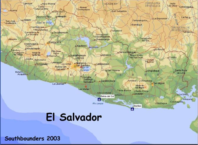
Salvador: There are two places in El Salvador: Bahia del Sol and Marina Barrias.
General
info: check in is free. Visas are $10.00 US each. Both anchorages have full time
navy presence, and (at this time) Bahia del Sol has
Immigration present during the cruising season (about November thru
June), and Barrias has full time Immigration. Money is being converted to US
dollars and is accepted everywhere, although 'colones' are still used and many
of the prices are still shown in colones.
Bahia del Sol (in the 'Estero
de Jualtepeque'): 13.16N x 88.53W
Good
calm anchorage, with easy access to buses. It is about 80 km from the capital of
San Salvador. Bahia del Sol resort (hotel/marina) has the following cruiser
services:
30% discount for food and drink,
happy hours on Mon, Tue, Thurs, Fri.
Cruisers night on Wed.
a free hotel room for one night. (as of this writing).
Anchorage
is free. Moorings are $5.00 US a day, and floating dingy docks and a marina is
under construction. Very little English is spoken. Call Bahia del Sol on channel
16 before trying to enter the estuary. Generally, they don't answer, but one of
the cruisers will, and will set up a time to have someone come out and guide you
in. The Navy will come out to your boat to check you in. Sometimes immigration
will come out with them. If not, you may check in with Immigration on the hotel
grounds.
Marina Barrias (in the 'Bahia
de Jiguilisco'):
Barrias
is very isolated, about 10 miles up the bahia/estero. Access to a bus is very
difficult, and taxis are expensive. They do take cruisers in (via van) to a
local town twice a week. Almost all employees speak some English. Call Marina
Barrias on Channel 16 before entering the bahia/estuary to set up a time to have
someone come guide you in.
Pros/Cons:
Bahia:
Pros: Cruiser friendly, easy bus access, free anchorage, good
restaurant/bar.
Cons: Entrance can be a *fun* ride sometimes, poor (and expensive)
internet access, Only some of the office personnel speak English.
Barrias:
Pros: Very cruiser friendly, private, isolated, easy entrance, good
internet access.
Cons: isolated (no access to bus), expensive (moorings), snack bar only
(which closes early), more mosquitoes then Bahia.
Please
note: I have only been to Marina Barrias by land, so all information is gathered
from other cruisers and the Marina personnel itself.
SSB
net info for El Salvador area:
Marine:
Pan/Pacific net: 8143.0 (8137.0 backup) at 1400Z
Panama Connection: 8107.0 (8167.0? backup) at 1330Z
Ham:
C/A Breakfast Club: 7083.0 (plus/minus) at 1300Z
Cruisers
in both anchorages monitor channel 16.
Please
feel free to drop me an email if you have any questions (I'm sure
there
will be plenty). Tootles, Diane,
svWindBird
As
you know, we are at Bahia del Sol and love it.
We have been here since May and have left the boat here while we went
back to the States and again for a land trip into Guatemala.
Here
is how to find us. Call on channel 16 as you get near the rendezvous point.
The hotel or one of the sailboats in here will answer you and send a
guide out to bring you in. The rendezvous point is 13°16.5N
88° 53.5W . This will put
you right in front of the entrance (boca).
Don't go by the chart. The
entrance has moved several miles since they made the charts.
You may need to anchor and wait for an incoming tide, best close to high
tide. Anchor to the north/west of
the above coordinates in 30 feet of water.
There is a big white house on the point.
It makes a good landmark. Stay
on the north/west side of it. Come
in close enough to get into about 30 feet of water but don't come in closer than
this. You need someone to guide you
in. The bar deserves respect and
you want a guide but don't let it scare you off.
This is a wonderful protected anchorage. Only rarely is it dangerous and if it is, you will be told
that.
Last
year we did have big swells in the late spring. Three boats arrived here at that time and anchored out for
three days. During that time the
Navy put a man on each boat to guard it while the cruisers enjoyed free hotel
rooms at Bahia del Sol. The
anchorage out front is safe enough but rolly.
The bar may keep you here a couple of days longer than you want once you
are in but that is just waiting for a good weather window like anywhere else.
The bar has not been closed since last summer so it is not an everyday
affair. Sports fishing boats go in
and out every day.
Bahia
del Sol is not a body of water. It
is the Hotel. The bay here is
Estero Jaltepeque, a totally protected anchorage with room for more than a
hundred boats. It is huge and also
very pretty. The hotel wants us
here, the more the merrier. They
give each boat one free night in a hotel room.
There is no charge to anchor or to use the hotel facilities. They do want you to spend a little money but $20 a week is
enough to keep them happy. They
have an excellent restaurant, a bar, huge swimming pool, new showers will be
completed in a couple of days, laundry, garbage disposal, a fuel dock, etc.
Happy hour is from four to six on weekdays, two for one. There is not a haul out
facility or repair facilities. The
buses to everywhere stop at the front gate.
The beach is beautiful and only walking distance away. We make good use of it.
The
town of Herradura is 25 minutes away by dingy. Supplies and hardware stores are
available there but really are kind of limited. There are also a couple of little tiendas and local
restaurants just down the road here from the hotel.
For major provisioning we take a bus in to Zacatecoluca or San Salvador.
We prefer going to Zacatecoluca which has an excellent US style super
market and it is not as far as the city. San
Salvador is a big city of several million people and anything and everything is
available there if you can find it. Taxis
are available too and for $35 Jose will take you in to San Salvador and be your
chauffeur and guide for an entire day. His
phone number is 747-2104. Jose
speaks good enough English and is very knowledgeable about the area.
There
are lots of places to go from here by bus, car, airplane or dingy.
You can leave your boat with confidence and you don't have to worry about
your dingy. We can leave them in
the water overnight without worrying about theft.
People that go inland can also leave their dingy on shore and the
security guard will watch over them. When
I had to go home for surgery I was confident that everything would be OK when I
got back two months later.
(Note
from Matt: we had to divide what we wrote into two segments.
Afraid Sailmail would truncate the message so you missed some of it).
Segment
2: As you can tell I am very partial to Bahia del Sol.
My info on Barillas is sketchy. We
did drive down to see it and were pleasantly impressed.
It also is a very pretty place
with lovely pools and restaurant. Security
is very good. The marina is
surrounded by a barbed wire fence and there are lots of security personnel. At Barillas anchoring is not an option. You must stay on a mooring ball which costs you $8.00 per
day. To our point of view, the
negative is the isolation. It is
very isolated, no buses here. They
have a van that will take you into town for shopping on Tuesday and Thursday and
give you about 4 hours in town at no charge.
There is a boatyard next door so some repair facilities are available and
I was told that a boat could haul out but only in an emergency. There is a Habitat for Humanity project ongoing here but I
don't have any info about that*. There
is also a free panga to take you to and from your boat. I think they want you to schedule your trips on the hour, or
maybe the hour and the half hour. They
have a very good internet setup. There
is a charge for using it; I am not sure of the amount.
*Note from Anne on MichaelAnne on Matt’s information
above: The project at Barillas is an Earthquake Relief Project that was started
right after the 7.9 Richter Scale earthquake that struck El Salvador on Jan. 31,
2001. Several cruisers got together
and collected money and chose a particular village where homes had been wiped
out to help. They managed to get a
$10,000 grant from the Canadian Government and lots of private donations.
Barillas Marina Club donated the use of a van and a generator.
The money collected was and still is used for rebuilding destroyed homes
and facilities. Between Jan. 2001
and now, cruisers have in the village of Santiago de Maria helped the villagers
construct 6 duplexes and 6 individual houses with better construction material
than that of the homes that were destroyed.
Homes were built only for people who owned the land, not rented.
Now they are working closer to Barillas and of late have helped to
rebuild and re-supply a local school. Work
still goes on wherever needed as over 1,000,000 people were left homeless by the
earthquake. All of this was done by
and through cruisers who were at Barillas.
The owner of Barillas has been extremely supportive.
We worked right along side the people when we helped them to
put up the homes...Dennis of KNEE DEEP taught several villagers how to weld.
Village women and children hauled buckets of cement for pouring
foundations. Villagers learned how
to lay out a foundation plan. Kids pitched in to paint the steel supports for
the wall frames. We all hammered
and banged and painted. Cruisers taught villagers to use a chop saw.
Neil of PARAQUINA helped with the wiring and taught a couple of local
villagers how to do it themselves. It
was a very worthwhile experience and all just by cruisers and locals doing it.
Barillas
is the easier approach in bad weather. I
understand it is accessible in just about any weather. Like here, you call them
on channel 16 and they will give you rendezvous coordinates and come out and
guide you in. You then have a 7
mile ride up the river. The
approach coordinates are 13° 06.77 N 88°
27.65 W. These coordinates may be
out of date so check with another source on this.
Don't
miss El Salvador, they even use American money here exclusively.
Notes
from Matt: the first message meant to say that sailing the rhumb line only saves
a few miles and the coastal route is safer in the Tehuantepec.
(Our opinion)
Boats with 8 1/2 feet
draft have been in Bahia del Sol. We
draw 6 feet. At low tide Murray was
out checking the channel and the lowest he saw was 9 feet and we have 6 to 7
foot tides. The sports fishing
boats seem to in and out at any time. However,
you need to come in on a rising tide. When
the current is going out and the swells coming in, they trip over each other and
it gets messy. With the tidal
current coming in it settles right down. Usually
boats come in within the last two hours of an incoming high tide. It is quiet
then and there is lots of water. We anchor in about 17 feet on a sand bottom - good holding.
Matt, S/V Elsewhere
“I
have been working on the log of the Chula Mula with way points, anchorages etc.
for you but it has been slow going. So
I want to tell you briefly that some of our best stops were at Barillas Marina,
El Salvador. We do not recommend
stopping at Bahia del Sol. It was
far too dangerous to go over the bar and if I had to do it again, I would not.
Other people loved it.”
“Barillas Marina
Club: (Waypoint at the entrance: 13°07.079’N/088°25.163’W.)
You can call them on Channel 16 anytime from 7 AM to 5 PM on Thursdays,
Fridays, Saturdays and Sundays. The
rest of the weekdays, you have to wait until 8 AM.
It is a good idea to let them know ahead of time when you expect you
might arrive. The e-mail for the
General Manager of the Marina Club is: hpineda@barillasmarina.com.
It takes about 20 minutes for the panga to get to the waypoint from the marina.
He will then lead you the 10 miles up the estuary to the marina mooring
fields. (There are NO berths, only
mooring balls.) Once the panga gets
you placed on a mooring ball, the driver will bring the customs and port captain
representatives out to your boat along with someone from the marina office.
Then they give you a ride into the marina complex and you go see the
immigration guys who have their office right on the property.
Bahia del Sol:
(Waypoint at the entrance: 13°15.760’N/088°53.479’W.)
We don’t really know the procedure there.
For a while they had immigration at the associated hotel, then they
didn’t, then they did. Check with
Matt on Elsewhere who is almost a permanent resident there now (or Colette and
Murray on Terezad who are residents, having purchased property nearby.
Personal note:
Bahia del Sol has a very shallow bar over which big waves break all the
time. It can be a dangerous ride,
surfing in over the bar and is even more dangerous when you are trying to leave.
Many vessels leaving even when the panga driver says its safe have taken
damage. People have been stuck here
for weeks on end, particularly after February when the big swells begin to roll
in from the southwest. These swells
last through October.
Be warned.”
“Bahia del Sol:
Although we did not stop in Bahia del Sol, which is about 30 miles west of
Barillas, we have had many good reports of the facility, with the chief
reservation being the approach across the bar.
The resort will come out and guide you in the daylight hours, and slack
tide is the preferred time. In any
kind of sea, it would be prudent to give it a miss.
The advantage of Bahia del Sol over Barillas is said to be more
“independence” with public buses outside the gate, plus a very attentive
hospitality. Neener 3 sent us this information for getting into Bahia del
Sol.”
“The stand by waypoint for Bahia del Sol is: 13'15.7N 88'53.48W
which is 2 miles offshore, we anchored 3/8 mile from shore, with offshore
breeze, at: 13'15.050N 88'52.190W
which is 1/4 mile east of the entrance, in 38' good holding sandy
bottom.........if it is blowing, the depth at the waiting waypoint is still only
58', 2 miles off, possible to anchor with plenty of room to the beach, try to
time arrival to high tide (La Libertad +40 minutes), we went out Monday on the
hotel 700 hp boat and check depths, found 2 channels through bar, never saw less
than 16' at either channel, the channel is deep at the narrowest part, 30-50',
it's were it(sand) fans out in front that gets shallow and moves around like
sand dunes on land.....the 2 big tides a day move lots of water through the bar,
both ways.......also flushes the lagoon and you can go in the water at the
higher tides, some boats make water then too, not us.............there are lots
of people here on weekends, only an hour to San Salvador by car, 2 by bus, many
wealthy Salvadorians have beach homes here, with hot boats and jet
skis......-FRI, very quiet again.......The lagoon is huge, will handle many
boats, ranges from 15-30' depth and runs beyond the hotel for 16 kilometers,
paralleling the beach on other side of peninsula, that's about it, oh, their
building 16 slips at the hotel, 2 showers by pool for cruising boats, this is
going in now, as we speak, 30%
discount on all meals, drinks, internet, laundry,
have a few moorings you can hook up to to go inland, the hotel picks up
at the airport and brings them to the hotel to do your check-in/out......”
“Barillas Marina:
Rendezvous waypoint is 13*07.126N; -88*24.977.
Call Barillas Marina one hour before reaching waypoint and panga will
meet you to guide you in behind the reef and up the maze of mangrove channels.
Reef entry is wide and easy. Manager is Heriberto Pineda.
You can email him in advance at hpineda@barillasmarina.com,
but it is not necessary. Marina has
75 moorings along the mangrove channel at $8 per night. Very tranquil with lots of bird life, cool nights and only
about an hour of bugs before sunset. Hourly
panga service to shore. Compound
has lovely pool, jacuzzi, palapas with Internet hook-ups, air-conditioned
computer room with a dozen or so machines, tiny convenience store, laundry
service, fuel dock (Diesel @$1.75) and a pretty restaurant facility with very
limited and pricey choices as well as limited hours.
Assume all services to cost you, except for the Tuesday and Friday
shuttle to Usulutan for shopping. Nice
supermarket and great street vegie vendors, especially back in.
Very nice golden cage! If
you want to do a tour to San Salvador or anywhere, including Guatemala, inquire
about Discover El Salvador. The
guides, Celina & Max, are truly special people, with a very nice
air-conditioned van. A trip to San
Salvador can include a stop at Price Smart.”
BAHIA DEL SOL, EL SALVADOR
We anchored off several
hours at 13°16.395N,088°53.391W in relative comfort. A navy patrol boat came
out to check on us and communicate when the panga would guide us in, at high
slack tide. We were the first boat in after the bar had been closed a couple of
weeks and had a bit of an exciting ride through the breakers, but if you follow
the panga and DON’T LOOK BACK it’s really a piece of cake. Dolphins escorted
us in. We’re a 31’ trimaran with a 8hp outboard motor… a little more power
would be better.
The little village of La
Herradura, a 20-minute dinghy ride up the estuary, has a good public market and
is like going back fifty years in time, while San Salvador, a two-hour bus ride,
is a big modern city. The Express bus direct to San Salvador comes by the hotel
entrance at 5:30 AM and 11:00 AM; otherwise transfer at Los Arcos.
The last return bus
leaves San Salvador at 4 PM (or a little before!); look for #495. Do you have a
copy of CRICKET’s very informative email about El Salvador? Our only
correction is the address of COPLASA, the excellent commercial fabrics store in
San Salvador centro which is hard to find: it is on Calle 1a Poniente, one block
north of Calle Arce. On Saturdays
you can call the States for about 15 minutes with a three-dollar phone card.
There are card phones in La Herradura; the closest one is about five miles up
the highway.
Jim went out almost every day to observe conditions at the bar and got to know the bumps and channels, so when we went out it was like slicing through the Red Sea with Moses, although the boat right behind us took a header from a sneaker wave. Timing is all. Dolphins also escorted us out.
The Passage from
Barillas Marina, El Salvador to “No Name” Anchorage, Nicaragua
“Some impressions on
the next leg of the journey . . .sv RAGTIME traveled from Barillas Marina to No
Name anchorage, Nicaragua. leaving outside the Barillas channel at noon 10
January, arriving No Name anchorage at 1 am on 12 January.
After exiting the channel from Barillas to the open ocean, we turned left
approximately 1.5 miles from shore and almost immediately hit a current running
west (north) against us. At best
the current ran 1 knot, at worst 2 knots. Probably
60% of the time it slowed RAGTIME down 1.5 knots; nothing we did to get the boat
moving at her regular cruising speed, 5.5 - 6.0 knots made any difference . .
.so we went. . . 3.5 to 4.9 knots 85% of the time.
We traveled approximately 4 miles offshore after trying unsuccessfully to
shake the current further in. Frankly,
we were hesitant to travel out further because of potential Papagayo winds and
wanting to be close to shore if the winds gusted up.
After speaking with and obtaining the recommendations from three boats
heading north, Annie Two, TACKLESS II and Po Oina Roa, we traveled with 2 reefs
in the main and the full head sail. We
encountered 5 - 25 knot winds, a crazy choppy confused sea and the
aforementioned current. Sailing was
great!! Mostly on a port tack. Off
the Nicaragua. coast, we encountered many lighted fishing pangas; the nets we
saw were parallel to shore, 0.75 - 1.0 miles offshore, all were marked with
flags and REAL colored buoys - red, yellow, orange and white.
The most concentrated area of nets was after Cabo Desolando, along the
"Venadillo Road", (see chart book, page 57) just after the power plant
at Puerto Somoza. We entered No
Name at 1 am, pitch dark skies. ENTRANCE WAY POINT FROM TACKLESS II: 11.30.036N, 086.12.572W; ANCHORAGE WAY POINT FROM THE
FORGOTTEN MIDDLE: 11.30.4N, 86.10.2W. The
anchorage is a WIDE crescent, easy to enter right down the middle. The bay is
well lighted and you can identify it from off shore. Look for lots of lights on beach at the head of bay,
specifically 4 "street light" lights in a row off on the SE end of the
bay. Drop hook in 22 - 26 ft water
0.25 miles off beach in SE corner. NOTE:
there are rocks and reefs on both the north and south sides of the bay,
but it is easy to enter right down the middle and anchor toward the southeast
corner at the head of the bay. You
will be very protected from the wind here.
As I write this, the wind is gusting to 45 knots off the land with calm
seas, no chop at all in the bay. Holding
is good. The pangas are NOT
anchored; they are beached. The
fisherman set nets close to the rocks and reefs at both sides of the bay. There are no nets in the middle of the bay.
This is a rustic anchorage with no services, very raw and beautiful with
friendly pangaroas. We hope to see you all in Costa Rica very soon.”
Ragtime
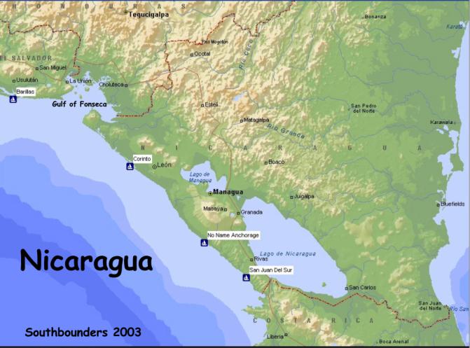
“No Name”:
(about 30 hrs at 5kts from Barillas) pretty much as presented in The
Forgotten Middle. For offshore
waypoint use 11*30.036N; 086*12.572W. You
can turn in a little earlier if you can see.
Waypoint in the book is the at-anchor waypoint.
Try to get in before dark and note position of buoys marking traps if
planning a pre-dawn departure. We
found clear passage out before dawn from the anchoring waypoint on a course of
260*C.
San Juan del Sur:
We enjoyed our stop here. Very
dramatic entrance with big cliff on south side.
Lots of fishing vessels on south side of anchorage.
As you enter try calling “Ivy Rose” on VHF !6. Sid is a cruiser who has been hanging out there awhile.
We anchored in 28’ (HT) at 11*15.390N 085*52.590W.
The surf will break in front of you, but the wind will hold you steady. The Port Captain & aide will come to your boat in blue
camies! Their Spanish is hard to
understand, but very welcoming. They
will do a search. I called the
Capitania on VHF 16 out of politeness as we anchored.
Capitania is the brown A-frame on the hilltop. If you just want a quickie
rest stop, with maybe a meal ashore, he will probably let you stop with no
paperwork. If you want to stay
longer, you will have to take a taxi (around
$15) to “frontiera” for Immigration.. This allows you to see Lago Nicaragua
with its two impressive volcanoes in the middle.
Fees were $15 Port Captain arrival, $9 pp Immigration in-and-out; $15 for
the boat at Immigration (?Customs) and $10 for the zarpe.
San Juan del Sur is a
charming beach town, relatively upscale for Central America.
A launch – a be-fendered local fishing boat – will collect you and
carry you to port facility. From there an easy walk into town. No supermarket, but there are corner tiendas and there is a
fresh market about two block in. We
bought Flor de Cana rum by the case for about $4.80 a bottle from a corner
tienda (ask Sid) and you can do a $1 better if you are there on a Wednesday
buying from the truck (See the gal at Ricardo’s Bar – burgers –real and
tofu – etc and young beach scene.) Good
breakfast at Sunrise Café (aka Iguana Bar) offered by Canadians morning through
midday. We had a great shrimp
diablo from El Globo.
No Name Anchorage – Nicaragua
Outside Waypoint at Edge
of Deep Water
11˚30.036” N
86˚12.572”W
Watch out for buoys on
either side of entrance…rocks on SE outer side, also middle to N.
Stay on the SE side of anchorage.
Inside Waypoint
11˚ 30.4 “N
86˚10.2 “W
San Juan del Sur,
Nicaragua and miscellaneous weather information:
“RAGTIME is sharing
information with all of you that was given to us by Gwen and Don on TACKLESS II,
with whom we spent several days at Barillas Marina.
All credit for this information goes to TACKLESS.
WEATHER:
David Jones Weather (call sign “Misstine”), 8104 USB at 1230 UTC –
Rapid fire delivery of comprehensive weather for Caribbean and SW North
Atlantic. This is the net you have
to pay $100 (or whatever is current) to be able to talk to him.
He offers the useful emergency contact service.
If you wait until the absolute end of his broadcast you can call as a
non-subscriber to get info about his service.
He also has a very good website at www.caribwx.com.
David Jones Weather Redux – 12359 USB at 1300 UTC – a second
broadcast aimed at Western Caribbean. Same
$ deal.
ANCHORAGES:
San Juan del Sur, Nicaragua: We
enjoyed our stop here. Very
dramatic entrance with big cliff on south side.
Lots of fishing vessels on south side of anchorage.
As you enter try calling “Ivy Rose” on VHF 16.
Sid is a cruiser who has been hanging out there awhile. We anchored in 28’ at ll.15.390N, 085.52.590W.
The surf will break in front of you, but the wind will hold you steady.
The Port Captain and aide will come to your boat in blue camies.
Their Spanish is hard to understand but very welcoming.
They will do a search. I
called the Capitania on VHF 16 out of politeness as we anchored.
Capitania is the brown A-frame on the hilltop.
If you just want a quickie rest stop, with maybe a meal ashore, he will
probably let you stop with no paperwork. If
you want to stay longer, you will have to take taxi ($15) to “frontiera” for
Immigration. This allows you to see
Lago Nicaragua with its two impressive volcanoes in the middle.
Fees were $15 Port Captain arrival, $9 pp Immigration in AND out, $15 for
the boat at Immigration (Customs) and $10 for the zarpe.
SJdS is a charming beach town, relatively upscale for Central America.
A befendered fishing boat will collect you and carry you to the port
facility. No supermarket but many
corner tiendas. Fresh market about
two blocks in. Good breakfast at
Sunrise Café aka Iguana Bar. Good
shrimp diablo from El Globo. Hope
this is helpful and thank you TACKLESS.” Patricia, Don and Pike
From MICHAELANNE:
“We
never checked in at Nicaragua but others have stopped at Corinto and San Juan
del Sur. Overall, the costs have
been around $100 per boat (with two on board). “
NICARAGUA
We anchored just outside the breakers each night, which was much more comfortable than bashing around in the lumpy seas.
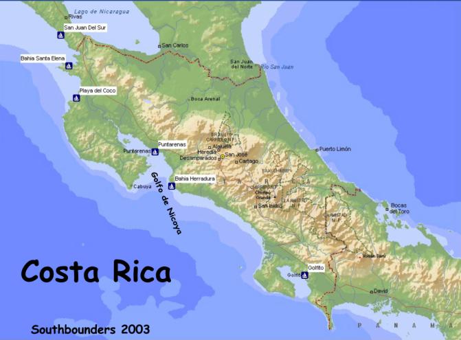
“Most cruisers stop at
beautiful Bahia Santa Elena first (or Salinas or some of the smaller bays prior
to Santa Elena...see Charlie’s Charts of Costa Rica) and no one has ever been
hassled by the Costa Rican navy or coast guard about hurrying on down to Playa
del Cocos to check in. So don’t
sweat it. When you do get to Cocos,
the check-in procedure is pretty easy. Stop
at the Port Captain’s office (Charlie’s is incorrect as to placement) and
let him know you’re there...then go to immigration way up the street, give
them what they want to see (boat papers, passports, zarpes) and know you might
have to make some copies, no big deal. Go
back to the Port Captain who in the meantime will have called the customs guy
(aduana) who is in Libertad, some 30 minutes away. The customs guy will come to Cocos and make out your
temporary boat import permit.
There was never a charge
for any of this. In October, 2002
the aduana tried to eke out $10 from Dreamweaver and some others but they said
“you’ve never charged any of the other boats anything.
Why are you trying to charge us?”
The aduana gave up the attempt. So
be warned. You will have to pay about $20 plus some exit stamp fees when
you check out of the country but there’s no charge for getting in so far as we
have known.
When you check into
Costa Rica at Playa del Cocos, be sure you get a ZARPE NACIONAL from the Port
Captain. This is the internal zarpe
and with this you don’t have to check in anywhere else until you reach your
final destination in Costa Rica as stated on your crew list ... this should be
GOLFITO. Everywhere in between,
including Puntarenas, you don’t have to check in as long as you have a Zarpe
Nacional indicating your last stop is Golfito.
Your visas and temporary
import permit are good for 90 days.”
Costa Rican Marinas:
Costa Rica allows you to renew your temporary import permit once for
another 90 days. After that you will need to put it in bond if you will be
leaving the boat longer than the second 90-day period.
Only a “qualified marina” can bond your boat. They charge different fees for this.
According to Tim
Leachman and Katie Duncan of Land-Sea Services in Golfito, Costa Rica, “...you
can bond for up to a year, allowing you to leave the country or just extend your
stay in the port you bond with. When you bond your boat, it means you cannot
move the boat anywhere although you are allowed to stay on it.
As far as customs is concerned, the time you spend in bond is more or
less equal to time spent legally checked out of the country.
So if you use up the 6 months of cruising (temorary import) permits, you
can enter bond for 3 months and then be eligible for 6 more months of cruising.
The marina facility
must have an agreement with the customs office to provide the bonding services.
In Golfito the Samoa del Sur and Banana Bay currently offer the service. Since
they will be legally responsible for securing the boat, they do have the final
say as to where they want the boat and what they will charge to provide the
service.”
“Marina Flamingo: Near
Playa del Coco. Docks with electricity
and water. Not always willing to accommodate you, especially short term.
A 42 foot boat paid $17 per day to stay there for over 3 weeks.
Dinghy thievery in the anchorage area is pretty rampant, especially if
you’ve been anchored there for several days.
Nighttime theft most common...they have taken dinghies right off davits
while the people were on board and asleep.
Not many services or goods locally available...you need a cab to get
anywhere. They have a gas dock
(floating) and you can get diesel and gasoline there. Check the tide level though.
Pretty steep range here. Cost
in October 2001 for diesel was about $1.89 per gallon.
Costa Rica Yacht Club,
in Bahia de Coco: This is the only
place in all of Central America that we know of that can dry store your boat for
any period of time. They have a good-sized travel lift that can handle almost
any vessel. They also have a
special haul-out railway for multihulls for work on the boat, but as to dry
storage, maybe not. A catamaran was
hauled in June of 2002 for $80 per day flat fee and that included the labor to
do the painting on the bottom. For
monohulls, haul-out fees in 2002 were $10 per foot out and about $400 per month
for the average 36-42 foot boat.
They also have wet
storage on moorings, fore and aft tie-up. We
stayed there for about 10 days and the cost for the moorings was $15 per day.
They have a fuel dock and the water is potable.
Panga service from the yard across from the club and from the moorings
was free. They have the services of
one of the best mechanics we’ve ever encountered.
His name is William and he is very talented and his prices are very
reasonable.
The club is way up the
Naranjo River behind Puntarenas and tide range is quite wide.
Call them on Channel 06 VHF for a panga to guide you up the river and
around all the sandbars. Carlos Chinchilla is the manager there and speaks good
English. Contact him by e-mail at: cryachts@racsa.co.cr.
Los Sueños:
Located in Bahia Herradura at the southeastern end of the Gulf of Nicoya.
There have been mixed reviews from various cruisers for this very
expensive marina ($2 per foot per day for transient vessels).
The marina manager is VERY UNFRIENDLY to any boats anchored out in Bahia
Herradura and discourages their use of his dinghy docks.
The shore landings at Bahia Herradura are difficult at best.
Banana Bay Marina,
Golfito: All bright yellow
buildings make this facility stand out. Docks
have electricity and water and fuel (highest price for fuel in town) and a very
expensive restaurant (food is good, though).
They also rent motel rooms for $75 per night. Laundry service is available for $3 US per load. Transient
vessels pay $1.25 per foot per day at the dock or may take one of their 3
moorings for $10 per day or may pay $7 per day if anchored out and using their
dinghy dock. Security provided for
vessels on moorings, but theft has occurred on vessels at the dock.
Contact them at bbmarina@racsa.co.cr.
Land & Sea Services,
Golfito: Located immediately next
door to Banana Bay, owned by Katie Duncan and Tim Leachman who have been there
for over 10 years. They have a
small dock to which one large sailboat may med-moor and use electricity.
They have also a houseboat to which they can raft two sailboats, no
electricity. Cleaning and bottom scrubbing services are available.
Contact them at landsea@racsa.co.cr
for berth/tie-up charges. For
vessels anchored out and using their dinghy dock, water, garbage disposal, and
24 hour security services the charge is $15 per week or $3 per day.
Laundry services are available as well for $1.60 per kilo.
They also have a collection of some of the most beautifully carved and
painted balsa wood masks we have ever encountered...half the price you would pay
in San Jose during high season. Katie
has an exclusive contract with the Borucan Indian artist and you won’t find
these masks anywhere else in Golfito. Katie
is also a property manager and real estate agent for the area.
She can also make travel
arrangements for you.”
“The bay Santa Elena
in Costa Rica was beautiful. From
Santa Elena to Cocos, first place to check in is a long day's sail.
Hang above Cocos and delay checking in, as this is the best of Costa
Rica. Once south of Cocos, the
water clarity sucks and is very very dirty.
The advertising on Costa Rica is overstated.”
In your prev email you
mentioned that your friend was looking for marinas in CR to leave his boat, here
are the only 3 worth mentioning. Los Sueños has excellent security but it is
not a cruiser type place, he could anchor out in Bahia Herradura and check it
out though. Their website is www.lossuenosresort.com, I don't have an email
address for them.
We would strongly
recommend Banana Bay or Land & Sea in Golfito. They are next door to each
other, and a third marina is being completed next to them. Website for Banana
Bay: www.bananabaymarina.com. Email address for Banana Bay: bbmarina@racsa.co.cr
and Land & Sea: landsea@racsa.co.cr Hope
this helps. Give him our email address if he wants more specifics.
Notes on Bahia Drake,
Costa Rica (Oso Peninsula)
“Hi All! We wanted to
pass along our thoughts on Drake's Bay (Bahia Drake)...we really enjoyed it,
it's on our"want to return" list. We bow and stern anchored for 4 days
and the current in there made it very hard on ground tackle, and each swing was
a jerk on the anchors, we went to retrieve the stern anchor and couldn't break
it loose, free dove and couldn't even see it! Kurt on WILDBLUE came over and
with 2 dinghys and combined 23 hp we got it up, so watch the current (tide).
We enjoyed hiking in 2
places, go in the river and the first dock on left, we asked and got ok to leave
dinghy on back side of dock, looking at it to the right and around the end. Go
up the steps and to the right, the trail starts there, and goes across the
suspension bridge, up the hill, at top turn left and follow path with turtle
reserve release signs....it goes back down toward the ocean, beautiful beaches,
coves and the trail is maintained, walked every day by Leon, and his machete.
The trail goes many miles, all the way to Corcovado National Park. Along the way
are monkeys, butterflies, birds and 2 people! Our favorite spot has a swing,
grass, and palapa...a very special place.
Back to the river, on
the right side is Drakes Bay Resort, tie off to the big white panga by the
concrete dock...ask for Eddy, the manager, say hi for us, and he will give you a
tour and invite you to use the salt water pool and the bar, with a happy hour!
We had a meal there, was great but it's off season and supplies are
limited...Vanessa, the hostess, is from Santa Cruz, Ca., our home, and has a
beautiful daughter named "Star", and she really is! She will lead you
to where you can pick the 'star' fruit. Have you had this delightful fruit yet?
It's our favorite of the tropical fruits. Vanessa's husband, Shuan, runs the
diving and whale/manta ray watching expeditions, all are really neat people.
We also stopped at the Paloma Resort, you will see it on the trail to the
coast, at the top of the hill from the suspension bridge, great for a cold,
cold, beer or soda on the way back from the hike. Again, very nice people... we
asked if they served lunch. With limited supplies, they fixed lunch from
leftovers for 9 of us, NEENER, SEA LOCO and WILD BLUE...a half of pizza, cheese,
green salad with all the dressing bottles, they had left in various amounts, and
Quiche! It was great after our hike. There is a little tienda on the beach,
veggies on Thursday, if the truck can cross the river, and a
bar/restaurant(red/white building past the soccer field) And go up the river
past the resorts, under the bridge and up as far as possible...many monkeys,
Howlers very high up and white face monkeys by the water, good fresh water swim
in a pool just before the rapids. If
Eddy asks if you would like to see the farm, do it...it's where they raise
veggies and beef, pigs and is a very worthwhile trip.
“Bahia Santa Elena.”
As per the book, but definitely one of
the most beautiful bays we have ever anchored in.
We anchored in NE corner near fishing camp as shown in CC. No bugs.
We snorkeled out at mouth of bay on the rocks to the east.
OK. There is a river you can
explore by dinghy, and a road along coast to west you can walk.
Paper nautilus shells have been found on western beach.
Key Point, Cabo Santa
Elena. If you need or want to stop
at Cabo St. Elena, we overnighted at key Point only we anchored to west of the
rocks (10*53.790 085*54.95W) instead of east of them (like the book indicates)
based on the advice on Jim McVeigh of Flamingo Marina.
We did not feel we were more protected from the hefty gusts, but holding
was good with lots of scope. The
Bat Islands are very dramatic, and small rays leap like popcorn.
Snorkeling was so-so.
Bahia Huevos
has a good report, but we didn’t stop
Bahia Culebra
has several well-protected anchorages. We
spent several days at Play Iguanita. Almost
as restful as Barillas. The beach
to the west of Playa Manta is said to have good clams (little thumbnail-size
ones.) Playa Panama had great reputation with Sid & Manuela of
Paradise, but seems to be closed by reports?
Playa El Coco
is a required stop for entry into the country.
Anchorage is no great shakes, beach is 50% dirt, and town has reputation
for theft. Lock boat up, don’t
leave it at night, and chain your dinghy to the dock when ashore.
Official offices a little hard to find, but officials very friendly.
From the dock, walk along the beach to the right.
There will be a small park. Take
a left after park. Your will see
the post office on your left. Port
Captain is behind post office. He
will direct you to Immigration, which is along that same street but on the
right, just before the Tequila Bar. Had good meal at The Tequila Bar.
There is an Internet Café across the street.
Supermercado fairly well
stocked, but poor on vegies. I
think Tuesday is vegie delivery day.
Bahia Portrero/Marina
Flamingo: We liked this bay a lot.
Maybe because we had such a rough trip in around Cabo Velas, and it’s a
big change from points to the south. Very
gringo/ resort area. Winds can set
up a bit of a chop, but holding was good with lots of scope.
No roll. Jim McVeigh runs
the marina and small chandlery. Can
orchestrate needed parts with patience. Dinghy
dock in marina proper. Not much
dockage available for transients. Fuel
dock in the second basin to the right. Fuel
dock easy to get on, but only about 7’ of water at low tide! Fuel around $1.50/gal. Water
free. Hangout was the Spreader Bar
at Mariner Inn, bunch of gringo transplants.
Internet at Costa Rica Diving. Good dinner deals at Marie’s. Hair cuts
and all luxury salon services available at the Paris Salon at Flamingo Beach
Hotel. There are no flamingos
around, but there are said to be roseate spoonbills.
Rental car was available for $28 a day.
Nearby is Brasilito. We had
a great dinner at the Happy Snapper there (we won it in a raffle!)
Also in Brasilito, a top notch Internet café that will allow you to
bring in floppies for uploading and downloading. They also have nice breakfasts.
An hour away is Santa Cruz which had a surprising market – Kion –
with some gourmet items, including wasabi, nori etc. While we had the car, we
checked out Tamarindo a surfer dude town. (Tamarindo
is a popular spots with cruisers that surf.
Anchorage looked rolly.)
Bahia Carillo
is the recommended stop to break up the trip from Portrero to Gulf of Nicoya.
Although the bay is pretty, it’s an awful anchorage.
The book shows two spots. We
chose the one on the left for the room. Very
rolly, albeit with good holding. The
other spot near the handsome hotel seemed cramped for two boats, esp. with hotel
boats there on moorings; also the bottom was billed as sand and rock.
Note:
We caught three tuna between Carillo and Cabo Blanco.
Also a couple of mahi in gulf of Nicoya.
Bahia Ballena:
Delightful stop. Medium
pretty, but very calm with howler monkeys in the hills.
We anchored in western corner off the cement dock. There is said to be fuel, although none of us did any.
Excellent dinner at the Bahia Ballena Yacht Club – great ceviche, and
pargo a la plancha with garlic yum!. On
Fridays you can buy organic vegies from the owner of the restaurant (Honey aka
Mrs Heart Interface). “Tambor”
itself is down the road, bear to the right.
You can walk along the main road or along the beach road.
There is a Swiss restaurant towards town called Perle Tambor (on the main
road look for obscure sign with a tiny Swiss flag/on the beach road it is a
white two story with dense gardens.). Their
food was quite different, not local. Doris
can arrange horseback riding, which we did when our daughter was visiting.
Small horses but well cared for; very good value at $5/hr/pp.
Great ride out along beach with howlers overhead.
If you can survive a 5-hour ride, you can go to a nice waterfall that
drops into the sea!
Islas Tortugas
Very pretty spot with the clearest water in Nicoya.
Where CC shows “public access”, many day trip boats anchor during the
day and small fishing boats often pass the night. “They” charge for you to come ashore at the beach!
We anchored instead off the near corner of the other island
“Alcatraz” just on the other side of the cut.
Snorkel boats do the little islands to the east.
First visit was quite calm; second visit quite rolly.
Gorgeous sunsets!
Punta Leona:
A really worthwhile rest stop. Anchorage
was mostly settled when we were there, but others have chosen to use stern
anchor. The Resort is an older one,
with development scattered around the huge property, which include both primary
and secondary rainforest. Highlights
are the nice walking trails and the free nature tours available 3x day (not
every day) Sign up at front desk. The
pools are nice and there are so-so restaurants and bars.
Grounds are gorgeous. Beach
access by dinghy, and roll it up. Playa
Blanca is a nice beach accessible by stile at SW end of Playa Mantas, and there
is a little waterfall on the beachlet on the east side of anchorage.
This is a good place to
leave the boat for short inland trips, especially if there are other cruisers in
the anchorage to keep an eye on things. You
can arrange for rental cars, either National at the front desk, or Budget by
phone. Both will deliver the car to
Punta Leona. We made several trips
to Jaco, a surfer dude town to south with a good supermarket and produce market
and Internet. We also did a day
trip down to Quepos, managing to get in to “The Rainmaker”, a fabulous
private park with the suspension bridges in the treetops without a reservation.
Not cheap but we paid about half price making do with a local Spanish
worker as guide rather than the bi-lingual naturalist.
We had the place to ourselves! You
can email for info at erguti@racsa.co.cr
or call 506-777-3565. Quepos is a
sizeable little town with stores and restaurants for gringos. Nice feather art store.
We did not do Manuel Antonio.
We also made a day trip
to San Jose (Price Smart and MegaSuper supermarkets, also Ace hardware) about
1:15 hr drive on good roads with some beautiful mountain views.
Later we took an overnight (two nights would be better) to Monteverdi.
This is supposed to be cloud forest, but when we were there it was crispy clear.
The turn to Monteverdi is a fast hour north on the InterAmericana until
you turn off and then it is 37 kilometers and 3 ½ hrs on a mostly dreadful 4WD
road. Hard to believe this is their
major tourist destination! Still it
was terrific. We stayed at the
Sunset Hotel in Santa Elena, neat clean and I think about $40. Fabulous sunset view. Avg
food. We did the Monteverde Canopy
Tour (in Santa Elena) and it was a BLAST. Good
value, as canopy tours go (this is the cable ride thing.).
The sleeper highlight was a turn down a side road between Canopy Tour and
Sunset Hotel north to little Tico restaurant which I fear I don’t remember the
name. The sign has a knife fork and
plate on it. The road is dreadful,
but the reward is a nice simple meal and (depending, of course on clear weather) a
truly awesome view of Vulcan Arenal and Lake Fortuna, a real bonus if your
aren’t going there independently.
Bahia
Herradura/LosSueños: The new
Marriott Hotel/Marina has a fuel dock. Otherwise
a rolly anchorage and a pricey marina, although many people like it.
Drake Bay:
We did not stop in at Quepos or Manuel Antonio in the boat. Said to be really rolly and it was really rainy when we
passed by. We did an overnight trip
between Punta Leona and Drake Bay.. Lots
of fishing boats, lit but no running lights.
Drake can also be rolly, but was settled when we were there.
Nice rest. Fringed by
wilderness resort camps, simple to elegant.
The resort to west reputed to have nice happy hour.
Puerto Jimenez:
We were here twice. We liked
it. Narrow anchoring shelf between
deep and shallow! Plan ahead.
Crocodile Bay is a nice sport fish resort, but we’ve heard they are
back to discouraging cruisers using their facilities as high season is back in
swing. The town is full of
backpackers, Internet Cafes and tour operators to Osa Peninsula.
If you hike, a day trip is well worth it.
We saw all four monkey species, a huge flock of scarlet macaws up close,
toucans, sloths, etc. We booked our
hike through Escondido Trex in Restaurant Carolina, but you can get the same
guide – Pedro -- through the beauty salon next door (his girl friend) for less
$.
Golfito:
A pretty bay gone shabby. We
disliked it our first week there (in August), but when we returned everything
seemed much nicer, albeit rainier. The
bay entrance is buoyed and there is a range.
There are three places to go after you turn right past the last buoy
(almost ashore!). Samoa is the
first “marina” on your left, The docks are really in poor shape. I stepped between them one night! Can you say disappearing act!
But the restaurant is good. Second,
you can anchor or take a mooring off Banana Bay Marina for $7/nite which
entitles you to their services, including check in and out (we think @$35) their
2-for-1 happy hour, and laundry service, and the best efforts of the security
guard. Vulnerable time is in rain showers. Or you can take a slip if available.
Quite pricey, but very good facility; we left our boat there for two
months. Only really secure option.
If you crave a burger this is the place to get it.
$5, but definitely, $5’s worth! Other
cruisers anchor off Las Gaviotas Hotel farther along in the bay.
Quite nice facility with good weekend BBQs and a nice pool.
Willie of TI8ZWW weather fame, often hangs out here on Pacific Child with
his young wife and her son. Prettier,
but downside is no security and vulnerability.
Golfito has surprisingly
good provisioning. Vegie truck come 2x a week, I think Monday and Thursday, but
ask. A Monteverde “cheese
product” truck comes about once every 9 days.
Great cheese and yogurt. (Try
the smoked cheddar.) . Most
convenient Internet Café is Coconuts Café.
They have a GREAT vegie burrito. Bought
a lot of meat from the butcher (; its on the side street that slopes up from the
main street just before Coconuts) and it’s the right hand (uphill) of the two
side by side meat markets.) Pork
and Lomito. 3 supermarkets,
the first on the left being the best. Mike
Restaurant, out of town to the south, has excellent Hungarian type food, and
Mike makes real sausage, breakfast and Italian, the you can buy in bulk.
Order ahead.
Also you have the Free
Zone. Taxi to the zone with your
two passports and obtain your “tarjeta”
(looks like an invoice) . Then
window shop and make your list of what and where.. 24 hours later you can return and buy two cases of beer, two
cases of wine, one case of liquor, and $500 of other merchandise per person for
good prices. There is one little
store that sells Planter’s Peanuts, candy, and sundries (shampoo, sunscreen
etc) for good prices too.
On
Cocos Island, Costa Rica: Chatham Bay, Isla de Cocos, Costa Rica
Latitude: 05-33.097N;
Longitude: 087-02.528W
24 June 2001
Our 364nm leg from
Genovesa Island in the Galapagos to Cocos Island was as gentle a trip as we have
ever had. The weather was mostly
gorgeous and sunny, the water temperature steadily warming degree by degree
enabling the 2Cs to shed clothes layer by layer. We haven't been in swimsuits underway since the Caribbean!
The winds were light, 8-15 kts from behind us, and we sailed most of the
way, resorting to the engine only in the wee hours of the night when our speed
dropped below 4 kts. It was during
one of these motoring sessions that we had our only boat mishap.
With a hefty pow, the exhaust pipe flange blew clean off the engine
dumping smoke and cooling water into the bilge!
The good news is that Captain Don had been suspicious, and we were ready
with replacement parts purchased when Captain Gwen was in Ft. Lauderdale last
February.
We caught no fish.
Every time Don would go to put the lure out, a booby would show up.
On our first day out we had a seriously bad booby day.
At 0630, just over the dicey part of our exit from Genovesa, a young
booby hooked himself and was being dragged until we could reel him in.
Fortunately it proved his upper bill was more wedged in the hook than
anything, and Don was able to shake him off with a little judicious use of the
pliers without major damage to his bill or the new lure.
Last we saw him he was upright in the water shaking his head, obviously a
little boggled from his experience. Unfortunately
our next booby incident around midday didn't end so well.
What we heard was a couple of thumps, and next thing a booby body dropped
into the water at my elbow! Our
best guess is that he flew into some rigging or maybe the wind generator and
ricocheted off the mainsail. He
landed head down and never moved. Very
sad. For this reason perhaps we
were much more tolerant of the pair of blue-footed boobies that rode through the
night on our bow pulpit. The fact that they will stay there with the sail
luffing and snapping amazes us. They
were, however, unusually considerate, sitting with their business ends forward
over the water!
We allowed ourselves to
go very slowly the last day in order to approach Cocos in the morning light as
opposed to midnight. This prudence
rewarded us with a spectacular arrival. Around
4am the last bit of moon rose with a bright planet alongside, and dolphins
paralleled the boat making comet-like vapor trails through the bioluminescent
plankton in the dark water. The
island was black and mystical, rising steeply to a cloud around the summit, and
as dawn gradually broke it became greener and greener until it was a color so
bright we couldn't believe it. Dodging
the seasons back and forth across the equator, we'd completely forgotten what a
dense tropical green could look like, although in truth I don't think we've ever
seen an island this lush anywhere! Waterfalls
actually burst from the sides and tumble directly into the sea!
(Opening scenes of Jurassic Park were filmed here!)
As we rounded the point
into the Chatham Bay anchorage, hundreds of frigate birds circled the boat along
with dozens of boobies, to the point camera work on the bow could be considered
risky business! Ahead in the bay
was just one boat, our friends Kathy and Bob on Briana.
We picked up a mooring, had a bacon and egg feast and a short snorkel
just to remind ourselves what warm water was, and had just dozed off in the
cockpit when the park rangers showed up to do business.
Before we knew it we were all arranged to do a dive that afternoon.
A little background.
Cocos, plus a dozen or so satellite rocks and islets, is one of the
premier diving destinations of the world. Belonging
to Costa Rica, it is entirely a Marine Park and is totally uninhabited but for
some park rangers and volunteers who reside in one of two stations, a small one
here in Chatham Bay, the other larger base half-way around the north side of the
island. There are no facilities
ashore for tourists, so all must come by sea.
The bulk of visitors to Cocos are scuba divers coming on one of two
top-notch liveaboard dive boats, the 115' Sea Hunter and the Okeanos Aggressor
(the latter at one time was skippered by my old Tropic Bird friend Dan
Morrison.) The other vessels that
trickle in are either cruising boats like ourselves, or fishermen, who, though
they can't fish in the park waters, are permitted to seek shelter here.
The fees for cruisers to be here are a bit steep, although not so steep
as rumor had it. For us it costs
$15/day for the boat plus $15pp/day for us, which is a total of $45 a day.
About like being in a marina. For
this you have a nice mooring (yes, we checked all its attachment points!),
access to fresh water (they have a pipe rigged in a waterfall that carries fresh
water out to an offshore buoy!) and an onshore laundry tub and showers, none of
which we need on TII but which are welcome amenities for many cruisers.
Diving requires having
all your own gear, including dive compressor.
Fortunately, since ours is still down from the failed hose in Galapagos,
the Sea Hunter was here and the very friendly captain filled all our tanks for
us. Then, as he was leaving on
Monday, he went one step further
and lent us a fill hose for our compressor.
The other hitches with diving here are we must be accompanied by a park
ranger and we have to get there in our own dinghies. This puts us at the mercy of the rangers' schedules and
restricts our range to how far we can practically get by rubber duck.
However for $4/day it's a good deal as you get a guide and, as all the
dives are drift dives, a chase boat that tows the dinghy along after you.
The diving had been
great. Similar to the Galapagos,
the waters are thick with fish, with 3-5' foot white-tip sharks as common as
trumpetfish in the Virgins and lobsters carpeting the rock faces (which may well
be a main reason we have to be shepherded by rangers!).
Unlike the Galapagos the water is warm enough for skins only and the
visibility is a clear 70', but there is still very little coral, which we have
since learned is thanks to the disastrous El Nino of 1987.
On one dive - Roca Sucia - we had dolphins leaping around the dinghy
topside and several schools of hammerheads swirling around the underwater
formations. Lots of marble rays and
turtles too. We've seen four huge
Manta rays, but every one of them was from topside.
It seems they like to glide just inches below the surface with their wing
tips curling into the air! I did
managed to get in with one briefly on snorkle and we hope we got a photo of
another at least 12' wide!
The downside of this
paradise is the amount of rain they receive -- 280" a year.
There's a reason it's green! Given
that, it's been relatively nice weather during the time we've been here, with
only one full day of rain and but two days of nasty roll!
The rangers say the best time of year is November through January.
Briana left Thursday
for the Galapagos, leaving us all alone ...for about four hours, the Okeanos
Aggressor arriving to fill the void of the departed Sea Hunter.
Friday afternoon, Kaylor the park ranger picked us up in the drizzle for
our last dive and took us back to Isla Manuelita, which is just north of Chatham
Bay. This time we dove alone,
Kaylor having an ear infection; we deduce we have passed inspection as divers.
We had some misgivings about returning to Isla Manuelita, the site of our
first dive, but they were washed away by the best critter turnout of all.
Many, many MANY hammerheads, and QUITE CLOSE, too!
Two divers are clearly less intimidating to them than four or six! It
raises the question of who is watching whom?
There were actually more hammerheads on this dive than the ubiquitous
white tips! We must have seen ten
marbled stingrays, swimming this way and that or on the bottom, and five very
large green turtles, three of which were circling together (mating?) and two
swam right up to us curiously. For
a grand finale....no, not the infamous whale shark,..sigh... BUT that elusive
underwater manta ray! We surfaced
to find Kaylor and Gabriel shivering in the rain, so we brought them home for
hot chocolate (their choice). It
was the one time there were no English speaking rangers in the group, but it
went just fine. Don had fun showing
them his engine room and the computer charting, but they were most impressed
with the solar panel installation.
Saturday we dinghied
around to Wafer Bay for a hike to Cacades Genio (like the genie in the lamp!).
The park provided us with a guide, a thirty-one year-old engineer
volunteer from Spain by name of Luis Sanchez.
He proudly displayed to us his first contribution to the park, a
supension bridge over a river made of steel cable, turnbuckles and chain-link
fencing! From the bridge the
path led through true rainforest -- this is primary growth rainforest and this
is a 2 million year old island! -- and up the river course itself.
It was perfect for these old Trini-trained waterfall-keteers, (Snake
would have loved it!) and the
conversations in Spanish on the way up made for great camouflage for the 2Cs'
lack of conditioning! There was a
lot of evidence of the destruction wrought by the islands' feral pigs rooting
around in the moist soil to dig up roots. We
also saw some neat birds, both males and females of the endemic Cocos finch, as
well as a white dove that hovered overhead like a hummingbird.
Luis said the Spanish conquistadores took them for the "espiritu
santo!" and they were so otherworldy and out-of-place, that we could
understand the impression.
All the way up the
upper course of the river were secondary falls leaking down the sides of whole
hillsides. Still the
"cascades" themselves, when we reached them, were superb.
I'd guess a 100'+ drop into a pool from two separate falls, and the water
temp -- unlike Trinidad -- was mild. You
will have to take our word for all this as we discovered at the falls, that I
had left the chip out of the digital camera!
Back at the boat, our
anchorage had swelled to included five Costa Rican long-line fishing boats.
These are wooden craft about 30-45 feet in length, all brightly painted
with crews of four to six people aboard. From
the top stick up up to a dozen tall poles with garbage-bag "flags"
rather reminiscent of the Baptist residences in Trinidad, only these poles are
used to mark the long lines when they are deployed.
When we left for the hike, the crews were congregating for a game of
"football" on the low-tide beach.
Don had given one crew a lift to shore, and inquired if it was possible
to buy fish. "Mas tarde,"
they said. Well, upon our return
the fishermen GAVE us a huge wahoo, a 40 pounder, already beheaded and gutted!
When we pressed the subject of what we could give them in return, they
opted for cold pills...they all had the grippe!
Don worked away steaking the fish, but even after filling up the freezer
we had so much fish left we gave the back half of it to the park rangers!
It was definitely a more effective way of getting a fish than throwing
all those lures in the water!
By dark there were more
than ten fishing boats and by morning fifteen. There are only three other
moorings in the harbor, so many of the boats instead of anchoring tied up one
behind the other making a string! It made for a surreal night landscape for not
only were the boats lit up themselves, but the marker poles each had strobes
firing off! All this was quite
educational for us as we learned quite a bit about how they fish, how long the
trolling lines are (1000 meters, with 250 snap-on hooks along its length baited
with squid) and what to look for as markers when we cross paths with them at
sea. We certainly will feel more accommodating next time we encounter these guys
in our course!
On our last day in
harbor, Kaylor and Issaac came by to answer some questions for for a potential
article about the Park. In Kaylor's
six years as a Cocos Park ranger, he tells us he has never seen an assemblage of
fishing boats in Cocos like this. Apparently fishing has not been good.
Many Costa Rican boats have in the past edged in to Galapagos waters.
Now, with the aid of the US Coast Guard, Ecuador is clamping down on
this, and indeed several Costa Rican crews have been arrested.
Kaylor does much of the offshore patrolling, and he's up all night making
sure no fishing is happening within the eight-mile limit.
Isaac told us, "Kaylor has many friends (sic) in Punta Arenas who
would like to kill him!" which
immediately answered our question of whether the fishermen regularly gave the
rangers fish like our wahoo.
It is hard to imagine
that we almost didn't come here. It
has been a special stop, not just for the beauty of the island and the superb
diving, but for some nice bridges between interesting and different people.
Today we prep the boat for our eastward trek back to Panama.
We should be underway at sunrise.
Some Internet websites
of interest:
Isla de Coco National Marine Park:
islacoco@ns.minae.co.cr
mv Sea Hunter: www.underseahunter.com*
mv Okeanos Aggressor:
www.aggressor.com*
Even more than in the
Galapagos, the best way to visit Cocos is on a liveaboard boat.
Actually, it the only way! Okeanos
and Sea Hunter are both very top-notch ships, very oriented to high-tech scuba
diving, but they do make some provision for shore excursions and kayaking etc. We are also told that the small cruise ships we saw in the
Galapagos do a couple of tours each year that include Cocos.
It is, however, hard for us to even imagine more than 20 people here at a
time! It's just not that kind of
place.
The only other way to
spend time at Cocos, it to come as a volunteer, minimum commitment being a
month. You can get information
about volunteering from the Marine Park website.
Bahia Santa Elena/Costa
Rica is a beautiful bay - can be very gusty. The enlarged insert of this bay on
our computer chart is completely off - use the regular scale chart. The entry
waypoint on the1991 Charly's Chart is also wrong. Correct entry waypoint at
Bahia Santa Elena is 10 56'708"N, 85 48'654"W, at a depth of 118'.
Explore the mangrove channel at the end o f the bay.
After that we anchored
at every anchorage listed in Charly's and found them all beautiful. Check-in
into Costa Rica is at Playa de Coco. Very friendly port captain, NO FEES! Get an
internal zarpe to Golfito. You also need a copy of the capt.passport and boat
documentation for the boat import document. The aduana comes to Cocos from
Liberia. Good provisioning at the super mercado in Cocos. There is an excellent
machine shop in Liberia but we don't remember the address. It's about 3 blocks
from the Central Market. Internet and Laundry are available in Cocos. Laundry is
expensive in Costa Rica.
Bahia Brasilito:
beautiful, anchored in north corner below Punta Salinas. Don't attempt a dinghy
landing at the beach. Marina
Flamingo looks pretty bad, fuel is available there.
Bahia Carillo: Another
beautiful bay, very rolly - we put out a stern anchor. Walk up to the Hotel
Guanacaste - gorgeous views - small grocery stores.
Puntarenas: Enter the
estuary to the Yacht Club at high tide only. Follow the line on Charly's. When
you get to the Muelle Moreno, call the Yacht Club on Channel 6 (Manager Carlos,
speaks English) for a guide to lead you in. (note your GPS points, then you can
enter/leave on your own). Buoys at the Yacht Club are $ 16/day. There is a
bar/restaurant/swimming pool. Fuel, water and laundry available.
Haul-out: Very
efficient, $ 400 in and out, no daily charge. Bottom paint labor:$200,
Petit-Trinidad Paint $ 95/gallon. They also have Oceanic Paint.
Certified Surveyor: Ing.
Mauricio Gomez Francescolo, Cell (506) 389-7340, FAX (506) 641-0241, 661-3836,
Email: GOVAFRA@hotmail.com, Tel.Home: 663-7925. Price for survey: $ 300. He
prepares the survey in English and Spanish. He wants pictures of the hull out of
the water. We had him survey Pipe Dream and found him to be very efficient.
We are presently in the
Gulf of Nicoya - don't miss this area. There are so many beautiful bays and
islands. Still don't know when we will cross the canal - heard lots of good
things about Ecuador and may head there first - who knows.
PUNTA LEONA, COSTA RICA
Pleasant anchorage,
pretty grounds. We sailed out on a heading for Bahia Herradura, and after three
miles were just able to tack back into Punta Leona. The currents are strong!
MANUEL ANTONIO
Follow the directions in
Charlie’s for entering. We entered from the north and discovered that a reef
extends well out from Islas Gemelas. Better to enter from the west and go
between Isla Salera and Islas Gemelas.
GOLFITO
Xinia at LandSea does
such a good job of washing, drying and folding laundry that we emptied our
lockers and took everything in for her to do… so nice to have sweet-smelling
clothes and linens again. The free zone is great for shopping. You have to get a
permit with your passport one day before using it, and it is a one-time use in a
three-month period. Five hundred dollars max; limit of 12 bottles of wine and 12
bottles of liquor each permit. A one-liter box of Clos chilean wine was $2.20;
here in Panama at the PriceSmart in David it is $1.89. A bottle of Flor de Cana
rum was also $2.20; in Panama it is $4.50. After we had purchased our booze (and
used up our limit) we learned that you can get the rum in 12 larger bottles.
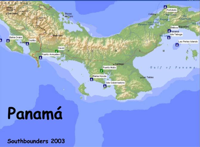
Panama is well
documented by the Zydlers’ Panama Guide.
Be advised before you leave Golfito that Western Panama does not have any
easy access to shopping. There is
very little development along the coast, which of course is what makes it so
beautiful. Most cruisers clear out of Golfito for Balboa and skip checking in at
Puerto Armuelles. . Panama
doesn’t seem to care that you are in their waters for months before checking
in. We cleared out there, and it
had some charm, but I wouldn’t go out of my way for it.
Only options for
civilization on this coast are, first, Pedregal and David, and second,Puerto
Mutis. Getting up the river to
Pedregal is a pain in the ass, either in your own boat (for which you need a
pilot and maybe two days), or by panga (3-4 hours on a hard bench in the hot
sun!) David, however, is a nice
little city, and should you need to leave the boat or make a plane connection it
is a reasonable option. Another
alternative is Puerto Mutis, accessed up the Rio San Pedro in the Bahia Montijo
just before Punta Mala. This is a
relatively easy trip on your own. Go
on a rising tide and follow Zydler religiously.
A
nice sidetrip is Boca de Trinidad. Puerto
Mutis is a tiny town (eat at Gladys) in a muddy stretch of river.
We anchored in 13’ on the opposite shore.
There is an hourly bus to the city of Santiago.
The bus goes right by the Super 99, a modern supermarket. If you buy too
much to carry on the bus you can hire a taxi/pickup for about $12 to bring you
back. You can get fuel in Puerto
Mutis (there is a dock, but we jugged it).
You can even clear into Panama in Puerto Mutis.
If you need to leave the boat, (via bus through Santiago; its about 3
hours to Panama City) ask around for Carlos Iguana.
He is a fisherman who can watch your boat and even run the engine to
charge batteries. There is
also a young American – Tom Yust- with a sportfishing business based up the
river to chat with. The Port
Captain can call him. They don’t
get many cruisers up here and are tickled when you come.
Punta Burica -
A rest stop, protected to west. Anchor
waypoint is 08*04.16N; 082*50.84W
in about 22’, another narrow shelf!
Isla Gamez
– Small island west of Isla Parida. Gorgeous
stop. Anchor on North side of palm lined beach.
Islas Secas-
Clearest water in Panama. Anchor near 08*04.931N 082*01.897 in front of
isthmus. Nice snorkeling on south
end on the little island to NE.
Bahia Honda -
Gorgeous Bay in the same league as Bahia Santa Elena.
Sounds like its still rainy, even in the dry season.
That should be slowing down. There
is a little island in the center of the bay with a village on it with some
stores, ice and a telephone. Where
the book shows “Yacht Club” is a private construction project, part of a
huge private development taking place in several locations inside and outside of
the bay. They don’t seem to mind
curious visitors, and we got a tour of the whole premises, including a jaunt out
to the residence going up on the island just north of the bay entrance.
We chose to anchor away from the construction, way in the sw corner of
the main bay off a little honeymoon beach.
Gorgeous.
Isla Catalina
- Nice lunch stop with yellow sand.
Isla Gubernadora
– In July we had a good anchorage on the east side of the island.
We did not like any anchorage along north coast of Cebaco.
That’s where we came
in from Cocos, having taken the “long way” around Punta Mala.
We have no knowledge of the Punta Mala anchorages.
Gulf of Panama- By the
time you get this far there will be many contacts with people who have
spent time there. Anchorages change with the season and we were there in March.
We liked Contadora, off the nude beach on the south side.
We went next to Pedro Gonzales to the southeasternmost anchorage which is
a gorgeous palm-lined beach. This can get bouncy if the wind shifts a little
east of north, and be sure to stay enough offshore that you can swing. We especially liked Isla Bayoneta (p. 260, the anchor is
actually between La Vivienda and Isla Malaga, although it takes some careful
navigating to get in. We approached
from the south (do not go between La Vivienda and the reefs, although it looks
possible, several boats that did hit reef.
Take those reefs to port.) and departed, after reconnaissance by dinghy
up through Canal Gibraleon at high tide. It
is very protected, and a dinghy trip around La Vivienda and to the beach is
really nice. Finally, a truly
peaceful spot is Isla Espiritu Santo, on the east side of Isla de Rey. Launch the dinghy and drive around to the east side and to
the tiny unnamed island to the east. It
is full of white ibis and we caught some snapper.
We also spent a few
nights at Isla Taboga. It is
pleasant during the week, but on weekend is plagued by jetskiis and runabouts.
Best as a close-to getaway from Panama City.
I won’t go into all
the Canal Info, as you will get fresher info as you get closer.
Simply suffice it to assure you that you don’t need an agent.
Balboa Yacht club is more expensive than Flamenco anchorage, but a lot
more convenient. Your best source
of info in the area is Pedro Miguel Boat Club, which is worth visiting for
Saturday Night potluck even if you don’t plan to stopover there.
Good people and a reliable mail drop.
They have a Miami address for shipping in parts.
Very efficient.
Do try to take in the
Canal Museum, especially if you have been able to get through David
McCullogh’s The Path Between the Seas, a fat tome on the history of the
canal. Available in Panama City.
Shopping is outstanding
in Panama City. Special highlights.
Mini Max for veggies and any Japanese or Chinese product you can imagine!
Nearer to Pedro Miguel for daily vegies is Fung Sick, nice vegies and fruits,
oftenall cleaned and diced for you. Nearby is Super Kosher, only place for whole
wheat flour, but has many other gourmet items (Try the Syrian breads in the
freezer and great canned hummus and eggplant dip, bulk spices,couscous etc.) Price Smart and Mega Max for bulk buying, but Mega Max canned
stuffed all too big. Down from Mega
Max and Abernathy’s (marine supplies and fishing supplies) is a great
supermarket with a women’s name (escaping me at the moment.) In El Dorado neighborhood,
large Novey Hardware store. Just
beyond it is a small plaza with a corner grocery that stocks canned chicken and
turkey. Only one anybody found!
Good Rey Supermarket, too. Liquor
can be bought duty free from Motta in Panama City, but its is most economical in
a group. (here’s a $50 customs agent fee.) If going through Canal, duty free is more readily organized
from Free Zone in Colon.
Note from
MICHAELANNE on above:
We never got there. Most
cruisers report that the authorities are pretty lax about your timing to check
in as you wander through the islands on your way to the Canal Zone...Zydler’s
Guide is pretty accurate so use that for info.
One note: The Flamenco Yacht
Club in the Canal Zone is not cruiser friendly.
They were not allowing cruisers to anchor out near their facility or use
their dinghy docks when we left in October from El Salvador.
For the latest on that, listen to the Panama-Pacific Net on 8143.0 USB
daily at 1400 UTC.
Boca Chica, Panama up
the creek to Pedregal and David:
Here are
waypoints/verbiage to enter into lower end of Boca Chica river - if you need to
reprovision in David after a while in the islands, or make the land trip to
Boquete. We anchor just off
Franks's, a German owned very casual restaurant/bar -
0.80c beers and very very reasonable prices for GOOD food.
Veggie truck comes Fridays to Boca Chica, and there is a telephone there,
and soon a diesel pump. Reuben in
the first house on the right has a King Cab pick-up - $15.00 to get fuel - a
2.5Hr round trip bumpy ride to the main highway.
He charges $50 for the whole day to do PriceMart & Super Baru market
(w/nice Internet). He can seat 4
plus himself, it is a bumpy ride first 45 Mins.
Best deal we found this
trip however was Victor's 12 Pass. Van - $13 ea to Boquete for 5 of us -
negotiable with more folks. $10 ea
for all day shopping in David incl. laundry stop/pick-up too.
Victor's phone No. is: 697 2809.
If you're on your own, lots of the backpackers use Victor for the Boquete
and David runs; and you will meet lots of them at Franks which is highly rated
in Lonely Planet.
1-08 11.975N, 082
13.545W
2-08 12.040N, 082
13.522W
3-08 12.058N, 082
13.491W
4-08 12.104N, 082
13.390W
5-08 12.181N, 082
13.172W
6-08 12.463N, 082
12.670W
7-08 12.602N, 082
12.670W
8-08 12.734N, 082
12.308W
We anchored off Frank's
dinghy dock at 08 12.763N, 082 12.407 in 30'.
We use Chart View Pro
& had good accuracy using chart #21584S0 - Approaches to Puerto Armuelles
and Pedregal. Make sure your GPS is
set to WGS-72.
First waypoint is close
to the West end La Ventana (P 258 Zydlers Guide), then turn sharp right (East)
make a fairly broad curve to Franks Point, which is on Eastern tip of Boca
Brava. You cannot see blue/white
striped roof of Frank's until you get closer.
Best time to come in is on a mid rising tide, so you can still see the
rocks. Shallowest water we saw with
above waypoints was 11' but we were before mid tide. Also see page 250.
If you enjoy the
Parida/Gamez and Secas as much as we did, this is a good spot to have a few
cooked meals with lots of backpackers coming in daily from all over the world,
get more fuel or veggies. The
trip into David is a nice drive apart from the bumpy beginning.
Monkeys come right up to the restaurant and the breeze is great up there.
Oh yes, they have a good dinghy dock.
We have not heard of any boat security problems here.
Lastly, we highly
recommend BAHIA HONDA as a fresh fruit provisioning option.
A lagoon-like anchorage, best spot is in the NW corner where it says 30'
in Zydlers - 7.45.932N 81.32.608W puts you near the small waterfall during rainy
season where we did our laundry. Domingo
comes out to offer his great fruits - He never quotes a price, but will accept
Dollars to put his 2nd daughter thru school and will also trade for anything he
needs like soap, rice, etc. Plse
give special greetings from "Janice & Dorsey on Sun Dazzler and Ted and
Shari on Mystique", if you get there.
You can leave your trash
at the fancy retreat being constructed in NE corner, and water from a spigot on
the beach. Couple of small tiendas
in village on island, poorly stocked, but they often have good onions, eggs etc.
and a telephone. Domingo can
take you to get Diesel ($2.25 gall) and Gasoline ($3.00 gall), which we all
bought from the fisherman’s home - fuel was fine but of course higher, priced
than Panama City. You pay the man
direct, and tip Domingo who shows you where it is (high tide is better) and
helps you.
Please spread the word
about Domingo; lots of cruisers have been very pleased there.
We enjoyed this quieter anchorage to do sewing projects, varnishing and
resting up before the Punta Mala "bash"; and Domingo is a very nice
man.
Experience with the
Panamanian Coast Guard
Confirming the net-com
this morning regarding being checked by the Panama Coast Guard.
S/V AKAUAHELO checked
out of Golfito CR for Balboa. A
little concerned about this because we will not be in Balboa for about a month.
We did not want to check in at Armuelles because we have heard it is
sometimes difficult there.
Our second day in Panama
we were anchored off the east side of Isla Parida and were kayaking around the
many small islets. A large, grey,
twin engine panga approached us and identified themselves as the Panama Coast
Guard and wanted to see our passports and papers.
Right ... like we always carry them in our kayaks.
We explained they were on our sailboat way over there.
The CC said "fine, lets go see them."
Great! So they followed us
as we slowly paddled back to AKAUAHELO. We
tied the kayaks up to each side of AKAUAHELO so the CC would not be able to
easily raft up to our hull. No
obvious fenders.
Brent got on the boat
and got our Costa Rica exit documents and passports and climbed into our dinghy
to give them the papers. The CC
guys were friendly but quite serious. They
inspected our papers for several minutes, asked some questions about where we
had been and what our plans were in Panama.
There was no question from them about the lack of fishing licenses even
though our poles were out in the rod holders.
The leader actually had his shoes off which was encouraging if they
intended to board us. Finally he
said, "everything looks in order, welcome to Panama".
They did not board AKAUAHELO for inspection.
So, it appears that what
we heard is true, once checked out of CR, Panama will allow you to travel
through their country without checking in until you arrive Balboa.
Happy Trails... Brent & Susan, S/V AKAUAHELO, Panama
Bahia Honda, Panama
For those of you who are
coming down to Panama I suggest strongly that you stay over at Bahia Honda. It
is a very lovely, lush and peaceful place with many small secluded anchorages
and nice water to swim in and it is absolutely calm water without any swells
when we were there for the few days. It is in the same league as "Bahia
Santa Elena" (Costa Rica) and we think even better.
There is a little village on the island in the center of the Bay with 2
very basic tiendas and a police station - (don't ask me why - this is so
desolate) The people there are very friendly and like their pictures taken.
Where the Zydler book references the "Yacht Club" located next to
"Islote La Mona" there is now a construction site and apparently this
is being developed (we didn't find out into what) by an American and Italian. We
did not anchor there as there are two moorings in the deeper water occupied by
two small boats and we didn't think we had enough swinging room. Also, this
little Bay shoals very, very rapidly from 30+ ft to 7 ft. and less - so, be
careful. This applies to many of the secluded coves - depths vary rapidly and
the holding is dubious in some of the places as the bottom appears to be a
mixture of small stones and occasionally some mud. So, plenty of scope.
We anchored in the Bay
to the left of the "Yacht Club" and managed to finally get good
holding in 25+ ft of water after making several attempts. When you drop anchor
there you will be visited by "Joe Domingo" in his dugout canoe who
will trade fruits and vegetables for milk, sugar and detergent. He lives up the
river on the west side of the anchorage and his son, Kennedy and his family,
live just off this anchorage and you can be assured of a visit also. Very nice
people. There is also a gorgeous cove just when you enter the Bay on your port
side. Beware, there is a shoal in the middle and we almost run aground.
Supposedly there are also some rocks - so watch out.
Our waypoints to get in
to Bahia Honda were (for those who might arrive at night - but beware - at your
own risk):
Off Isla Pacora 07 43.265 N 81 35.403 W
Off Punta Guarida 07 44.120 N 81 32.348 W
Off Isla Talon 07 45.049
N 81 32.126 W
Our anchorage
07 45. 892 N 81 32.293 W
Fair winds, Tom and
Kathy, S/V Tai Tam
Just a quick note and
comments on our recent passages. We left Bahia Honda in Panama on the 9th and
made our way to Punta Mala to get into the Guild of Panama. On our way we
stopped at Puerto Viejo on Isla Gobernadora - a small island just north of Isla
Cebaco. This is a good anchorage - very isolated and we put the hook down at 07
33.995 N 81 11.526 W. Good holding
and not rolly. When you leave there to continue to Punta Mala you have two
choices: 1. Backtrack and go west around Isla Cebaco or 2. the somewhat shorter
way, go east across the north side of Cebaco. This requires some careful
navigation as the depths are limited i.e.
you must follow a channel and stay within it otherwise you risk running aground
at low tide.
We choose that option
but were confronted with another problem once we rounded Cebaco. The southerly
swell started building up in the channel between the mainland and Cebaco due to
the much reduced depth. And believe me, these were rollers. So, we had to follow
a zig-zag course to take advantage of the areas with greater depth and therefore
lesser rollers. So, be careful and watch for shoals and resulting swells. For
the night we put into Ensenada Naranjo - also a very picturesque anchorage and
only a little bit rolly. We anchored at 07 16.444N
80 55.531 in good holding ground.
From there the slogging
began the next day as we started to run into adverse current and strong winds on
the nose. The decision you have to make is to whether to go further offshore -
say 7 miles or so or stay in as we did about 1 mile off the coast. We talked to
someone who went further out and who had stronger currents than we did but much
less choppy seas because the water depth is much greater than the 100 feet or
less you find closer to shore. So, you pick your evil.
At times we were down to
2 knots punching into the seas. So, be prepared for that part of the trip and
have patience as you approach Punta Mala. We intended to put into Punta Guanico
but were advised against it by another cruiser who had been there a day earlier
- 6 ft seas and breakers in the anchorage. So, we went 10 miles further east to
Benao Cove and dropped anchor there amongst a just borderline swell. Just as
cocktail time started I looked off the stern and saw a big wave coming at us,
about 6-7 feet, that I thought was going to break into our cockpit - it didn't
but that was enough and we raised anchor just as it got dark and made a beeline
out of there and continued throughout the night to the Don Bernardo anchorage on
Isla Pedro Gonzales in the Las
Perlas Archipelago.
This is about the nicest
anchorage we have ever been at, small, white sand beach, clear water and palm
trees along the beach. No swell whatsoever and light winds from the north - just
lovely. The holding ground is sand and we are at 08 23.986N
079 04.966W - don't miss this anchorage! By the way all of these
anchorages are in Zydler's book.
Tai-Tam on the Las
Perlas Islands
Just a quick note to let
you know that you should not miss the Las Perlas Archipelago in the Gulf of
Panama. This is an absolutely pristine cruising ground (top rated by us before
Mexico, El Salvador and Costa Rica)without civilization and just one beautiful
island after another. The water is fairly clear and somewhat cool and refreshing
(75 degrees right now) and allows excellent snorkeling or scuba diving around
the many rock outcroppings. All of the beaches have white sand and shell
collectors can also keep busy here
We are currently on Isla
Pedro Gonzales at the Don Bernardo anchorage. This has a very beautiful white
and palm lined beach with only one local resident who goes by the name of Leonid
living in a very funky house on stilts. Leonid is very friendly and loves to
trade fruit for anything "American" and basic supplies such as rice,
powered milk and clothing. At night only the stars and no electricity surround
us here and the light rocking of the boat puts us to sleep at an early hour.
Anchoring is a bit more
difficult here than along the more Northern Coast of the Pacific as there are
many rocks and shoals and one must use "eye ball navigation"
judiciously - although Zydler's "Panama Guide" is a must and of much
help. All of the Panamanians we have met on our way here from Costa Rica have
been great, very friendly, outgoing and curious. One thing to bear in mind
though is that there is not much opportunity for provisioning until one reaches
the Panama Canal, so stock up in Costa Rica.
If you just want to take
it easy and enjoy lots of nature, these are the islands to be. We strongly
suggest a week or two for those making their way to the Panama Canal - where we
will be a week from now.
Fair Winds, Tom and
Kathy Knueppel, S/V Tai Tam
In Panama, which we
liked a lot, Isla Gamez (my favorite), Isla Secas, Bahia Honda, Isla Pedro
Gonzales, and Contadora in the Perlas Islands.
Puerto Mutis & Bahia Montijo, Panama
Puerto Mutis, as a major
supply port for Western Panama fisherman, is the only fuel dock readily
accessible for cruising yachts between Puerto Armuelles on the Coast Rican
border and Balboa Yacht Club in Panama City!
At high tide a typical cruiser needing fuel could pull right up to the
wall and have the hose passed down. (We opted to jerry jug.)
It also has good road and bus connections to civilization, another rarity
in Western Panama.
The catch is that Puerto
Mutis is six miles up the Rio San Pablo, which is at the north end of Bahia
Montijo, which itself cuts a 15-mile deep wedge into the watershed of Veraguas
province. On paper it may look way
out of the way, but, just west of Panama's bulky Penisula Azuero (i.e Punta Mala
and Punta Mariaco), it is located ideally midway on a coast that offers little
other easy options for getting fuel. Additionally,
Veraguas, the only province in Panama with both Caribbean and Pacific coasts,
has, on the Pacific slope, lighter than average rainfall during the rainy
season, resulting from the unecological clearing of the natural forests to make
grazing land for cattle.
Fortunately, accessing
Puerto Mutis is straightforward on a rising tide with the Zydlers' indispensable
"Panama Guide" book (no boat should think of cruising Panama without
it; we have used nearly every page!) Plus, unlike Pedregal further to the west, the trip upriver
can reasonably be accomplished in a day by most boats, and the entrance to the
river system is protected by Isla Cebaco lying like a breakwater across the
Bahia. Although Pedregal, once you reach it, has an actual marina available for
cruising yachts and the larger city of David is much closer at hand, there is
much suspense about which entrance to the estuary will be usable given swell
conditions, the bars in the waterway shift about, and there are high tension
wires that cross the river inland from Boca Chica that sure looked low to us (we
went up river by panga from Parida.) Stories
about sailboats being stuck on bars for days and even one of a boat being rolled
in the surf, discouraged us from going to Pedregal!
Bahia Montijo has none
of these drawbacks. The bay itself
is quite shallow, and over a dozen rivers empty into it from all sides. Many of
these are navigable at least for a ways. Ever
prudent, we followed the recommended course which kept us in 30-40 feet of water
most of the way.
Before going on to
Puerto Mutis, however, we did take one of the many available side excursions up
a watercourse that led to an inland lagoon called Boca de la Trinidad.
Dense mangrove forests, much taller than we could have even imagined back
home in the Virgin Islands and matched by root systems able to survive the
ten-foot tidal range, encircled the anchorage. The lagoon was the most still
place Don and I have ever been in our lives!
Herons of several colors were the most common bird, plus a few parrots,
pelicans and frigates. There was no
hint of man in sight, no motors sounds or electric lights.
We were attracted here by reports of roseate spoonbills, but we had to go
hunt for them. Many herons later,
after puttering deeper and deeper into the low tide flats, we finally found one
dead tree with eight pink birds that, of course, all promptly launched
themselves and flew away! Clearly
this is an area worth visiting in its own right!
After a couple of days
relaxation we backtracked out to Isla Verde, and going all the way around,
continued on upriver to Puerto Mutis.
Travelling again on the rising tide, which is an hour later than the tide
station at Isla Cebaco, the lowest water we saw was nine feet.
In addition to refueling, our hope was to find Puerto Mutis to be a
secure place to leave the boat for several days while we traveled overland to
Panama City. The town proved to be
even smaller than we imagined, a single road climbing at an angle up a hill.
The basin off the town was dotted with a couple dozen wooden fishing
boats, but we found a spot for ourselves where we'd have enough water at low
tide practically on the opposite shore! Another option for deeper draft boats is
turning up the Rio de Jesus just before Puerto Mutix.
Despite the muddy river, the bottom was sand, and with plenty of scope we
had no problem with the 9' tides or any squalls.
Puerto Mutis proved to a
delightful place, albeit very, very small and simple. There are only a couple of eating/drinking places -- Gladys'
became our hangout--, and even fewer little tiendas with hardly any products to
sell. People, however, are very friendly and eager to chat!
When we checked in at the police station the officer promptly called the
only American in town, who turned out to be a young man named Tom Yust.
Tomas, as they call him here, is one of those folks who seems to have
been everywhere and done everything. Most
recently he has put several years hard work into building a sportfishing charter
business based on the wild island of Coiba, to the west of here.
(See Tom's fantastic website at www.coibadventure.com.)
Later we discovered that
we were able to get our cruising permit for Panama (we had just come in from the
Galapagos & Cocos) right next door to the police station.
Immigration, however, must be done in Santiago (or, as we did, in Panama
City if you are going there.)
Busses do the 50-minute
trip to Santiago every half hour for $0.95.
You could pop off halfway in the town of Montijo for basic groceries, but
in Santiago, the bus passes right by a well-stocked Super 99 whose manager Jose
Felix was particularly friendly and helpful. There is a panaderia right across the street, and if you have
all you need the bus stops there on its way back as well. If you have too much stuff, you can catch a cab back for $12,
and this will enable you to beg a stop at the fresh market, a street full of
fruit and vegie stalls, on the way. Prior to our provisioning run in Santiago,
we'd filled a cooler with "exotic...aka green" vegetables at Panama
City's wonderful Mini Max (oriental greengrocer in Patilla area) and brought it
back on the bus! You won't find a
lot of such "exotic" stuff in Santiago, although there is a second
modern supermarket called Machetes in a mall on the Pan-American Highway (but it
is not on the bus route) that has some different cold items, with a great
Spiegel/True Value hardware next door.
To travel to Panama City
you can catch a bus at the terminal in Santiago, or you can hop over to Los
Toucanes Restaurant, a few blocks away on the PanAmerican Highway, and try to
snag the Express bus from David making its pit stop there.
It is allegedly faster. Our
trip took us 3 hours for $6 on a Saturday.
The return was a bit slower on a weekday.
Everybody in Puerto
Mutis knew we'd be gone for three days. While
I doubt anything would have been touched regardless, we did hire a fisherman
known as Carlos Iguana to look after the boat, even to running the engine (from
the cockpit) and hour and a half each night.
He came recommended by Tom Yust, and it was a great choice as everyone in
town clearly held Carlos in esteem. The
boat was safe and sound with batteries fully charged upon our return. We paid
him $20 for his services.
PANAMA - We’ve been
here three months now and haven’t checked in, which doesn’t seem to be a
problem. Another boat did check in at Pedregal (only because they were flying
out of the country); their visas as well as the boat permit were given for 90
days, not the 30 days mentioned in most cruising guides.
The water is clean and
clear, fishing is good, islands are unspoiled, the people are lovely and
generous, and you can get almost anything in David or Panama City, cheap. Around
Isla Parida, local fishermen with lobster and dorado will trade for goods like
powdered milk and dulces; they will come to your boat. The shrimp boats will
give you iced camarones in trade for food and rum (no money); you have to go to
them.
PEDREGAL, the port of
David, is a five-minute taxi ride ($2.50) into David. You can anchor off the
Pedregal yacht club in about ten feet of water, and for fifteen dollars a week
get use of the dinghy dock, water, and trash. There is fuel there with gasoline
($2.20) and diesel ($1.70)… prices as of January 2003. The port captain and
aduana are right there at the yacht club; you take a taxi into David for
migracion. There is a small minimart and a restaurant.
There are several ways
to get to Pedregal:
1.
You can anchor your boat in Boca Chica and call Victor (cel phone
603-7511); he drives a 9-passenger van and will pick you up in Boca Chica, take
you to David, run you around, and take you and all your stuff back to Boca Chica
for six or seven dollars per person each way, depending on how many of you there
are.
2. From Isla Parida,
where you can leave your boat in relative security in Bahia Varedero, it is a
1-1/2 to 2-hour trip by panga. You can hire a local panga for fifty to seventy
dollars to take you in and bring you back the next day. We like staying
overnight in David.
3. If you take your own
boat to Pedregal, you can either go through Boca Brava if you have good local
knowledge, or from Boca Chica if your mast height is less than 50-58 feet (no
one seems to know exactly how high the wire is that goes across from Boca Chica
to Isla Boca Brava).
BOCA CHICA. There is a
big rock right smack in the middle of the narrow channel just past the wire.
This uncovers at low tide but otherwise you don’t see it.
This is a very dangerous rock, not mentioned in Zydler’s, and I would
not proceed under the wire until I had identified that rock by dinghy at low
tide. If you can get under the wire, you’ll see you have to cross over to the
Boca Chica side of the channel just before the wire and be sure you are very
close to the Boca Chica shore at the narrowest part of the channel. Also, the
current runs strong here so time it so you don’t get swept onto the rock. We
anchored close to the Isla Boca Brava side between Frank’s restaurant and the
sport fishing private dock, then explored by dinghy at low tide.
We were also surprised
at the location of the dock in the entrance, which is shown in various locations
on different charts. Page 250 in the Zydler guide is the most accurate; entering
up the recommended channel leaving Isla Linarte to port, continue that course
until you can see the channel opening past Boca Chica, and only then turn left
towards Isla Boca Brava to favor that side of the channel.
DAVID.
We really like David. You can walk almost everywhere, and find lots of
good stuff…industrial fabrics, hardware, etc. Lots of household goods for one
dollar. Taxis are one dollar to anywhere in the central city, two dollars
further out including Pedregal. Speedlan internet café is open 24 hours,
air-conditioned, with the fastest machines we’ve ever seen, for a dollar an
hour. It is safe to wander down there at night. PriceSmart, plus three very nice
supermarkets well stocked with American stuff and other goodies. A huge cartful
of groceries, including meats and booze, won’t cost more than a hundred and
fifty dollars. City water is potable (also at the yacht club).
Four-plex cinema with current movies. MacDonalds, KFC. Good barbecued
chicken dinner at El Molino ($1.50 taxi from town center). Yamaha (also handles
Yanmar), Suzuki, and Johnson outboard agencies. Three bus companies; trip to
Panama City is approximately eleven dollars, six and a half hours.
Very little in marine
parts in David, e.g. no epoxy resin; but Jim took the bus to PANAMA CITY and
found West System epoxy and just about anything you could get in the US. Four
nice marine stores in Panama City: Abernathy,
Centro Marine, NautiPesca, and Novey. All taxis know these. Travelift at
Flamenco: 150 tons, can handle beam to 25 feet, possibly 26. At this time $300
in and out, three lay days included, $1.65 per foot per day thenceforth.
There are many nice
beaches suitable for careening and taking the hard in the vicinity of Isla
Parida and Pedregal.
This passage takes you from Isla Parida via the channel leading westward from Boca Chica to Pedregal Yacht Club.
We anchored at Isla Gamez, off the NE side of Isla Parida. Many people were camping at Isla Gamez during Mardi Gras. Small boats were coming and going and the women were coating large pots of great smelling chicken and rice in red sauce. We were conversing with them when all of a sudden in this primitive setting, we jump at the sound of 2 cell phones ringing. I guess the men in Pedregal wanted to know if dinner was ready!
We decided it would be fun to go to Boquete, a mountain village 90 minutes from David by bus. David is a short taxi ride from Pedregal Yacht Club. From David, you take a bus to Boquete. You can also go to Boquete from Panama City, a 7-hour bus ride. We chose to go by boat!
We read the instructions on page 252 of the Panama Guide, but it seemed confusing. As we left Isla Gomez, we spotted a boat coming in and asked for directions. They told us we needed a guide, and loaned us their 16-year-old boat boy, Tatin. Tatin took over the wheel and guided our boat through the channels and surf safely to Pedregal Yacht Club. The trip took 8 hours for 35 nautical miles and the minimum depth found was 6.5’. The river scenery was interesting, with many channels, islands, and fishermen in dugout canoes. The current in the river approaching Pedregal can be quite strong, depending on the tides.
We anchored off the PYC, along with four other boats. Another sailboat arrived the next day. This boat was taking on water, since it had hit bottom so many times. It had no guide.
During the second night out, our boat dragged in the strong current and softly bumped another boat. Our anchor marker float had wrapped around the anchor and lifted it as we turned with the tide (no more anchor float!).
We went to David and then to Boquete by bus. The town of Boquete is a quaint mountain village with a mountain stream and two very interesting run-down bridges to cross (scary). We visited “Mi Jardín Es Su Jardín”, a wonderful artistic display of flowers and plants. This is a must see! There are many shops, restaurants, and places to stay. David has all the large grocery stores for provisioning.
We left PYC at 7am to go out the Boca San Pedro channel. We were told the shrimpers used this channel. All the cruisers (monohulls) said they would not use this channel in case they hit bottom. They were right. We managed to get all the way to the buoy and surf. We hit bottom (4.5’), a wave lifted us up and full throttle ahead, another wave or two, and then the big one came over us, and then all was well, except for the wet cockpit and salon (oops, two top hatches open!).
It was shallow for a half hour, and then we were safe in deep water. Quite an experience, but we would recommend returning via Boca Chica, with a guide, if possible.
It is interesting that these are the type of adventures you don’t want to experience, but once completed, you want to share with others.
Beverly and Paul
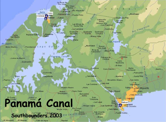
The Panama Canal is a
CASH operation. For boats under 50
feet in length, the transit cost on April 4th, 2002 was $500.00 US
Dollars. The measurement fee was
$50.00 US Dollars. A REFUNDABLE
deposit of $900.00 US Dollars is collected at the same time the transit and
measurement fees are taken. You can
use Visa, MasterCard, et.al., BUT while it appears that you are signing a credit
voucher just as any other purchase, it is a cash advance. You will not be informed, but it will show up on your next
statement. B of A was kind enough
to credit the cash advance charge when I complained a few months later.
Here’s how it works:
Call for a measurement. The numbers
are posted in several guides. The
measurer will come out and check your documentation, insurance, etc.
He will measure the length and width, ask you what speed you can
maintain, do you have line handlers, etc. His
tape is very liberal. This 42
Valiant grew to 46 feet under his tape. He
measures from the very end of your anchor to the last thread of the flag that
flies behind you. Pull everything in and take your dinghy off the davits if it
applies. Take his paperwork to
CitiBank and pay the fees. You will
sign two vouchers if you’re using a credit card, one for $550.00 and one for
$900.00. They will process the
$550.00 and it will show up as a cash advance on a future statement. The $900.00 voucher will be held until you complete the
transit and as soon as the paperwork is turned in, they will destroy the signed
voucher. That is unless you damage
the Canal and they want you to pay for something. The $900.00 is a security
deposit.
About 48 hours after you
pay, you can call and see when they have you scheduled through and whom you will
be going with. The measurer will
give you the number and what time to call.
If you are scheduled to make the transit in one day, the pilot will board
early. Ours arrived at 5:30AM.
Most likely you will be scheduled with one or two other boats, nested
together, and put in the center of the lock.
As with us, schedules and methods can change.
We were nested on the uplock but they split us up, delayed us at Gamboa
cut, and we tied to a tug on the way down.
We had entered Gatun locks just before 8:00AM and we cleared into the
Pacific just before sundown. We
arrived at the Flamenco anchorage well after dark.
If you can’t maintain enough speed to cross in one day, or if there is
a commercially generated delay, be prepared to anchor overnight in the lake and
continue the next day. It’s not
all bad, because the bass fishing is great!
You will need four
125-foot lines sufficient to hold your boat.
The measurer will want to inspect them when he comes aboard.
They can be rented, but we found it easier to purchase a 600-foot roll at
Nautipesca and make our own lines. I
intended to keep them and make new mooring lines but someone offered to buy them
from me at my cost on the other side. Tires! You will notice that boats getting ready to transit, and
those having just transited, will have automobile tires tied as fenders.
They can be obtained from just about any taxi driver for $3.00 apiece, or
you can just get on the radio and take them from someone who has come through
for no cost. Wrap them in trash
bags and secure the bags with duct tape. Use
old painters, lines, etc. to tie them to the cap rail.
Don’t tie them to the lifelines because they get some serious pressure
and pulling if you have to tie to a tug or the wall when going down. Avalon had
ten on each side.
We suggest that you
volunteer as a line handler one or two times before you take your own boat
through. The experience is
invaluable, you’ll learn about procedure, and you won’t be near as nervous
when you are at the helm.
Finally, it is a
tradition to feed the pilots and line handlers on the passage.
The easiest thing is a sandwich bar, but some get real elaborate and put
on a feast for the crew as they are motoring across the lake.
It really is a good experience and good food and drink make it more so.
A few facts from the
Panama Canal Commission plus the editors comment.
Entering a lock chamber
is a humbling experience in a small vessel.
These gigantic structures, when they were being built, required a
continuous pour of 3000 cubic yards of concrete every day for two and one half
years! To put this in
perspective, figure that your 2000 square foot house filled to the ceiling with
concrete would hold about 590 cubic yards.
The locks are 1000 feet
long and 110 feet wide, and each one is deep enough for a ship with a 39 foot, 6
inch draft. There are 100 four-foot
diameter openings in the bottom of the lock that allow it to be filled or
drained in 12 minutes. There are no
pumps; every thing is gravity fed. Every
time a lock is drained, 50 million gallons of water are released from Gatun
Lake. On average, 45 ships a
day, every day of the year, pass through the canal. Do the math, and you can see why Gatun Lake is the biggest
manmade lake in the world. Figure
also, that the only source of water replenishment is the rain that falls on the
Isthmus of Panama. No wonder that
there are some beautiful rain forests in this part of the world!
Sailing across Lake
Gatun, you pass over a part of the original Panama Railroad, built between 1850
and 1858. It was a popular route
for the forty-niners traveling to and from the California Gold Rush, and it
played a major part in the construction of the Panama Canal. It is said that a man died for every tie under the tracks.
That is probably an exaggeration, but thousands did die.
The fatality rate during construction was about 20% per month.
A train ran every day to collect the cadavers, which were pickled and
sold in the US and Europe for teaching and medical research.
Talk about recycling!
Fifty trainloads of rock
and soil were removed every day during the height of the excavation through the
Continental Divide. The French
failure in their attempt to build the Canal was partially because they
couldn’t figure how to get rid of all the spoil.
An American, John Stevens, an expert in railroad construction, designed
an ingenious rail system for removing the excavated dirt.
Today the cut is being continuously widened and dredged.
Mother Nature is still angry with man for making that scar and she
continues to try to fill it back up.
Finally, the average
ship passing through pays $50,000.00 US dollars for passage.
No wonder the Canal pays for itself!
Small boats under fifty feet such as us pay $500.00 US dollars.
It costs us more for the insurance than it does for the passage.
The Wet Bar is anchored
at the Bridge of the Americas, Panama City. What a place! Ships pass within 100
yards of us as they make their way to & from the canal, there's activity 24
hours a day. Panama is as beautiful as Costa Rica, friendlier, and alot more
affordable. There are lots of cruisers here and more arrive each day. Happy New
Year with best wishes for good health and happiness always.
We are anchored off Isla
Gamez, Panama and it is beautiful. Caught three yellow fin tuna on our way over
from CR and Greg has caught a red snapper and a giant needlefish since we've
been here. Greg & Meg
14.3 Tai-Tam on Preparing to Transit the Canal
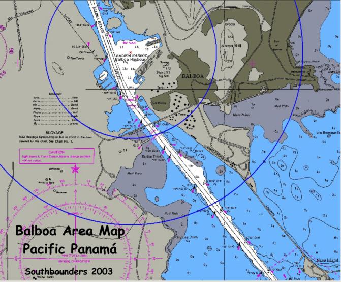
We are now at the Balboa
Yacht Club after having spent some wonderful time in the Las Perlas Archipelago.
We have just completed all of our paperwork and the visit by the Admeasurer and
are now waiting to find out when our transit date might be. Here is some
information that might be of help to you once you get here.
Places to stay: You have
essentially two choices, namely going to the Balboa Yacht Club (BYC)or staying
at one of the anchorages at and around Flamenco Island.
BYC costs a one-time fee
of $ 25 and then $ 0.50/ft/day. You cannot use your dinghy and must use the BYC
panga drivers to get to and from other boats and/or land. You should consider
tipping these drivers occasionally if you do not want to wait an eternity. The
club responds (sometimes/mostly) to channel 06. There is a fuel dock (don't know
the cost) and there is swimming pool - military version, many years old that you
can use if you pay $ 35 instead of $ 25 one-time fee. There is a small toilet on
the dock with a shower. There is a small BYC tienda style restaurant (Hamburgers
etc.) and also a TGIF in the hotel just across - food is not too bad at US
prices. Before I forget it, there is a local Cruiser's Net from 0745 local time
on channel 67 which is also the local hailing channel.
Anchorages: We are
staying at the BYC as it is more convenient but have heard that there have been
two dinghy motor thefts last week at the anchorage. Water apparently you can
take on by taking jerry cans to a seawall and if the tide is up fill these cans.
Don't know about dinghy landings but there must be one. The anchorage is
obviously free of charge.
Getting to BYC
Stay in the shipping
channel (red-right-return <bg>) and wait until you get to Buoy 14 - don't
turn there!!! continue to 14 1/2 and then turn into the mooring area - you see
the masts. The panga drivers will help you with the mooring lines which are
attached to the mooring ball. Watch for anyone who approaches you to sell you
tires. Don't - this is all part of the package price - see below under drivers.
Cab Drivers outside the
BYC.
There are 3 main guys
(Tony, Enrique and Louise). All of them speak more or less fluent English and
they are the ones you should hire to get you to places and to get you the tires
and lines and line handlers (if you use locals). The cost appears to be $ 8 per
hour for them to drive you around. The cost of the line handlers is $ 50 per man
per transit - you need 4 people. The cost of the package (4 lines minimum 125 ft
and 7/8' plus mucho tires - we use 14 ! should be $ 65 to $ 80. This is for a
rental not a purchase!
Canal costs as of
4-22-02
Boats <50 feet (this
means from the bowsprit to the end including everything hanging over like
davit's is $ 550 plus a $ 900 buffer fee. Boats 50-80 ft are $ 800 plus $ 900
buffer. Here comes the trick: Effective May 1st if you stop over in the Pedro
Miguel Boat Club - PMBC -(we are doing so) you will have to pay a further $ 450
once you are ready to leave the PMBC. Also, rumor has it but the Admeasurer did
not confirm this is that there will be an issue with the speed of smaller boats
like ours. I hear things about 8kts. What this appears to mean is that if you
cannot go at a high speed i.e. not
make the transit within a certain time - you will pay extra - don't know how
much.
You can pay by Visa card
- contrary to what you might be told not Mastercard or American Express. The way
this works is that at the Balboa Citibank office they take an imprint of your
card and do not fill in an amount and you must sign it!! Feels good to issue a
blank check - doesn't it? Your only receipt is your copy of the Admeasurement
Clearance form on which the clerk writes your fees.
Paperwork
Assuming that you stay
at the PMBC and that you will stay in Panama
after clearing the Canal. You will need to go to the Immigration shack at the
foot of the BYC. Then to the Immigration office in Balboa. Cost $ 10 per person
to get checked in. Then to the Port Captain to get you cruising permit. $ 65 for
3 months. You will check in there and pay $ 4 in stamps which you have bought
before at a Bank. As I said earlier, the Cab Drivers will drive you around. It
took us about 1 1/2 hrs. So, you do not need an Agent!!!
If you just make your
transit and continue to get out of Panama you don't need a cruising permit and
you check in and out at about the time when you know your transit date
approaches. The number to call to check on your transit date is 272-4202. Fair
winds, Tom and Kathy, S/V Tai Tam
Tai-Tam on the Pedro
Miguel YC in Panama, Miraflores Lock:
We have now been here at
the Pedro Miguel Boat Club located on the Miraflores Lake in the Panama Canal
for over a week and I remember that when we came south we had heard and read a
bit about this Club but didn't have too many details on it. So, here it goes for
anyone who might be interested:
The Club goes back many
years and it is my understanding it was initially set up for "Zonians"
(the Americans who lived in the Canal Zone before Panama took over on Dec. 31,
1999) and was used by them to keep their boats in a club like setting.
Apparently, during those days the "Zonians" could move their boats
along the Canal for $ 20 per transit...so, it made sense to keep their boats
here even though there is not anywhere else to go unless you make a transit to
the Caribbean or the Pacific or go to the Gatun Lake which many years ago was
open to boats.
The Club is now somewhat
dilapidated (but quite charming and funky) and there is an ongoing dispute with
the Panama Canal Commission about the Club's future but apparently the land
title is in dispute and nobody seems to be able to resolve the issues. So the
Club moves along having become a haven for cruisers going South or North. It is
really the only place where one can keep his/her boat for longer periods of time
in a safe and protected environment in the Panama area and you can do your own
work on your boat as there is a crane and dry storage facilities are available.
Crane rental is $ 160/hr and 6 jack stands are included in the dock fees -
additional jacks for $ 3/mth. You can also rent scaffolds and high pressure
washers.
The current dock fee is
$ 0.35 per (Admeasurer!!!) foot if you stay less than a month and $ 0.25/ft if
you stay over a month in addition to a one-time Club membership fee of $ 15
every 3 months. The docks are
borderline and rickety and all of the boats are secured by many, many lines
running from pilings in the water to moorings, to other boats....quiet a spider
web <bg>. You should see the activity once a boat decides to leave! In
addition, the water depth is questionable all throughout but do not fear, the
bottom is very soft mud or crud that does not harm your boat's bottom. Most
boats appear to touch ground and slowly carve themselves a bed as they move
around from the wash of the commercial tugs moving the large freighters. We have
seen several boat pulling themselves over the mud to get to their destination.
Even though you might be apprehensive at first it is not an issue.
Theft is not a problem
at the Club as the facility is secured by an infrared perimeter alarm system and
patrolled by geese and crocodiles <bg>. The showers and toilets are very
basic but the water is very hot and has good pressure. In the clubhouse there is
a large kitchen for use by the club's members (you) with stoves, microwaves,
coffee makers, blender, toaster, kitchen utensils and several large freezers and
refrigerators where most of us store some of our food. There is also a soda
machine which sells sodas or beer for $ 0.50. The club also has several washing
machines and dryers and you can use the telephone system free of charge to make
local calls or long distance calls can be made if you pay for them. The club
also provides free Internet access using their machine or you can use yours for
$ 20/month. There is also a TV with Direct TV where you can get your fill of US
movies and/or news. Transport to and from Panama City is easy as the Club is
served by the SACA bus systems ($0.35 or $ 0.50 for the air conditioned bus)
For shopping you either
go into Panama City or each day the Bread man comes to the Club or on Fridays
the Vegetable Man. You can also walk about 1 1/2 miles to a small store or take
the bus. Panama City obviously has many large US style supermarkets and a number
of marine suppliers. You can also
get mail and parts easily to the club from the USA using the Club's Miami based
freight forwarding service.
Lastly, here is the
email address for the club: pmbc@pmbc.ws or you can email the Manager directly
(Katherine) at kat@pmbc.ws. The phone number is 507-232-4509/4184 and the fax
number is 507-232-4165.
If you need any further
info, you know where to find us. Fair winds, Tom and Kathy, S/V Tai Tam
Don’t try to get
your Chain Galvanized in Panama!
We are at last in
Ecuador at the Puerto Lucia Yacht Club. We
are at a slip surrounded by rock breakwater and travel lift so Net reception is
lousy. I have a QST that I hope you
can pass to other cruisers going to Panama.
GALVANIZING in PANAMA
Our anchor chain was
beginning to show a need for re-galvanizing so I investigated services in Panama
City. We had the chain galvanized
at CLAVOS Y ALAMBRES PANAMENOS. They
had a hot-dip tank and samples of their work that appeared quite good.
We got the chain back in about a week and the galvanizing looked
excellent, no burrs and a good price. But,
after leaving Panama and anchoring the chain is now a total rusted mess.
All the galvanization has disappeared and the chain is probably ruined.
And this result after about seven days anchoring.
We strongly caution all cruisers about galvanizing in Panama and
especially using CLAVOS Y ALAMBRES PANAMENOS.
Regards, Brent &
Susan, S/V AKAUAHELO, Ecuador
BOCAS DEL TORO, PANAMA
Bocas del Toro YC and
Marina, where we are and are leaving the boat, is a new marina, not really a YC,
friendly people, Elaine & Cortney, clean showers, 3 each, calm,well
protected...we had a good feeling here as soon as we arrived. The water in the
marina is so clear, you can check out your keel and prop from the dock! Cost is
$7/ft/mo plus .20/KWH electricity. email: bocasmarina@cwpanama.net.
Phone is 507-616-6000, ask for Elaine. The town is a short dinghy ride,
very caribbean in a funky way, kinda laid back, you know, Cruzer
Style.........has internet, fast, Bank with ATM-Visa, Veggy stands, airport,
Gourmet store, small Marine store that can get stuff from PC on the shuttle
plan..........good walk around town. You won't believe the clarity of the water!
I haven't been to the other, Marina Careneros, 20 slips, med tie, no
finger slips, but had dinner with TAI-TAM Sat nite, They are there, and moving
over hear after their month is up.....1 shower, cold, and the managers fight all
the time.......same price, it's across the channel from town, more lights and
noise. email: marcar@cwp.net.pa
No phone.... for us, we love it, there are bugs, mangroves, no see-ums,
at sundown if it's not raining, RAGTIME was right, we leave in the morning, fly
to PC, Delta to ATL, on to LAX, rent and drive up to go Santa Cruz.
Panama Canal: (we transited canal from Caribbean to Pacific Feb 14, 2001)
- Approach from the Pacific – visit Las Perlas Islands, stay at Balboa YC vs near-shore island anchorages/bus trip
- Check-in in Balboa (country check-in, not Canal), Cab from YC
- Call the Canal Authority: Arrange Visit from Admeasurer
-
Measure boat (you hold the end of tape measure, so don’t go over 50’)
- Pay - $500 < 50 feet + $800
refundable “buffer” : Visa or cash only: Pay at bank.
Appointment to transit
– call anytime past the afternoon of making payment at the bank – they will
probably accommodate any date you want.
Trivia Question:
You’re going from the Pacific Ocean to the Atlantic. What direction do you go?
West!
Before the transit:
Make trip on another boat
Line up yachtie linehandlers
Get lines in order: 4 @ 125 ft. (two 200’ anchor rodes will do) There are some available to rent, or you can borrow from your linehandlers boats. (Travel back and forth between Colon and Balboa is quick & easy by bus)
Tires – $3 each or free from boats coming to Pacific - $1 to get rid of in Colon or give/sell to people on Atlantic side.
(more people coming than going)
Food for crew & advisor for two days.
Day of transit:
Get
your line handlers on board. (early)
Your
transit will be announced on radio the night before and in the morning.
Advisor
arrives on Pilot Boat – they tell you when on the radio.
Probably
a waiting area on Pacific side.
Transit: All locks on both the Atlantic
and Pacific side go up in the morning, then down in the afternoon. Then up in
the evening (no yachts allowed after dark) then down at night. So the trick for
a one day passage is to start early, go fast between locks, and hope the right
ships are available to get in the lock with, since you can’t go in with a
Panamax ship, and they aren’t allowed at night either.
- First set of Locks is the
Miraflores double lock. This is where the WEB CAM is. Check the site on the
internet and have your friends watch. There are two sets of locks side-by-side.
-
Freighter goes in first going up from the Pacific. It takes a while to
get tugs/mules in place. Freighters use their own prop for forward propulsion,
so you’ll wait for him to stop. Your
advisor will tell you how they want you (center tie, rafted, alongside a tug or
side wall).
- Monkey’s fists from hand
line men. Put a 3 foot loop in end
of your lines ahead of time, then tie an easily untied knot with the hand line
(sheet bend best for different diameter lines)
- Up you go – 30 feet.
Stay tied up until freighter leaves (turbulence) and goes into the 2nd
lock. Then you go in behind him again and go up another 30 feet.
- Exit the lock into small
man-made Lake Miraflores. It’s about a mile across to the Pedro Miguel Lock
– a single lock. If you’ve arranged it ahead of time, this is where you’ll
stop at the Pedro Miguel YC.
- Follow your freighter into the
lock and go up another 30 feet.
- Now you’re up 80 feet and in
the Gaillard Cut. You’ll motor along the side of the channel for about 7 miles
until you get to Gamboa, where Lake Gatun starts. The Chagres River that feeds
Lake Gatun comes in from your right – it’s jungle and there are crocidiles.
We stopped and swam, then got warned by Canal Authority officers about the
crocs.
- You continue across Lake Gatun
another 20 miles or so and if you’re lucky, there will still be enough time to
finish your transit in one day, otherwise they’ll have you anchor nearby and
finish up the next day. They will pick up the pilot, though, so you’ll only
have your crew and line handlers on board.
- Going down, you’ll go into
the lock first and the freighter comes in behind you.
Can be exciting!
- Last lock and you’re back in
salt water in the Atlantic. Your advisor will direct you to the Mooring area for
yachts and his pilot boat will pick him up.
Now you can enjoy beautiful downtown Colon!
Colon and the Panama Canal YC:
Leave quickly! … Colon is not a
pretty place! OK cheap beer and
cheap food at YC, we did restaurant or two in town, great deals in duty free
shop for adult beverages, we used the MOTTA store (go in with other yachties to
share delivery cost … good Chilean wine $2-3/bottle).
Check out using a local
taxi guy, if you didn’t check out in Balboa.
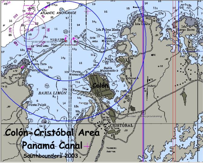
Colon:
The marina at Panama Canal Yacht Club isn’t bad if you need it.
Most people anchor in the flats (be sure you are within the buoys!) and
dinghy in. Colon is not quite as
bad as its reputation, but it isn’t great.
Always use a taxi. Shopping
is much less good than Panama City. Cruisers
occasioanlly organize busses to PC. Colon
is best for getting into a buying group for the Free Zone. Very cheap liquor. Double
check with the locals boats, but I think you just clear out from Colon to
wherever your next major destination is, regardless of plans for the San Blas
Rio Chagres: Although
to the west of Colon, this is a lovely getaway.
The entrance takes some attention, but the river is gorgeous.
We liked the first major bend. We
did motor all the way up river almost to the dam and then came back down.
It was not as tough getting back to Colon as we imagined.
Colon to San Blas:
It is a bit of work to get east from Colon to the San Blas, but it is
well worth it. The San Blas are
very special islands with a fascinating culture trying hard to hold on to their
own ways. The farther east you can
get, the purer your Kuna experience. If
you are squeamish about less than US sanitary conditions, don’t go.
Go open-minded and you will have a delightful time.
Portobelo:
first anchorage headed east. Gorgeous
in its own right. Be sure to hike
the forts. Easy busses to Colon,
too.
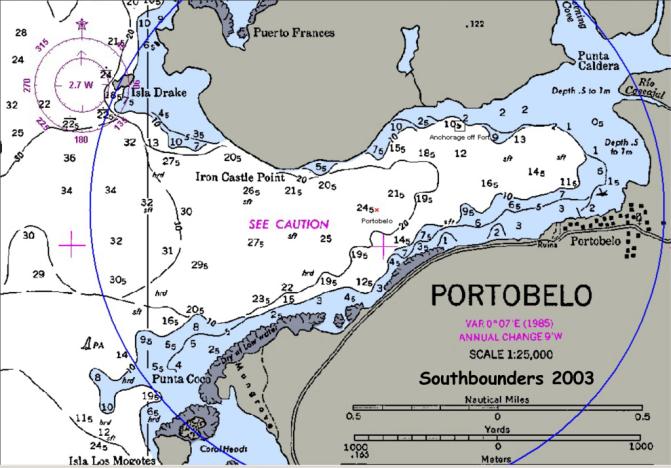
Anchorages between Colon
& San Blas Islands: We came from Cartagena (w/ NE winds) but sizable group
of yachts go to Panama down the west coast of central America & thru canal
after transiting the canal, head east along Caribbean coast of Panama.
1st stop;
Portobelo Columbus 1502, Drake used
port as base in 1570 to rob Spanish merchants, returned 20 yrs later to destroy
fortifications, died nearby at sea (Isla
Drake); Spanish continued to use as gold & silver storage port until British
invasion in 1739
2nd stop:
Isla Linton or Isla Grande - nice
scenery, clean water, long bus ride to Panama City
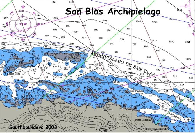
Jose Pobre:
Funky little moored “marina” for boat storage behind a reef, popular
w/ Europeans. Not much anchorage
outside. Memorable octopus in Jose
Pobre restaurant.
Isla Linton:
Another nice spot but crowded. Tuck
as far in behind Linton as you can to avoid roll.
Half tame spider monkey on the island’s dock. Keep a distance, can get nasty.
Great birds on private estate ashore.
Wait here for weather window to go east; leave early. Head
for Chichime. Need to get in
daylight. Forget Porvenir.
Isla Grande:
Busy local vacation hotspot. Rolly
anhcorage. Striking pass out
towards San Blas (pay attention to charts, submerged reefs.
San Blas Islands:
The are several important things you need to know about San Blas.
To start, I highly advise you to color in your Zydler charts for the San
Blas. There are reefs all over.
Zydler is your most dependable resource.
Use a different color for islands, for reefs, for recommended anchorages
and then highlight the route that looks best for you.
This is a huge help.
Next, you need to know
about Julie Arias and Panama Yacht Services (email aariasjul@pananet.com;
507-229-7110 or cell phone 613-6337. Julie
can help with anything from shopping for you and air freighting it to a strip in
San Blas to meeting guests and getting them from one airport to connecting
flights etc. She is a delightful
person and worth every penny! Fortunately
food is so reasonable in Panama City that even with freight and her service fee
it is not out of line with the Caribbean. Last, don’t try to avoid paying the
silahs. Paying the silahs gives you
rights in the community.
You could spend years in
the San Blas (and many people do) and not see all the islets and anchorages.
We’d recommend Chichime Keys, Nuinudup in Eastern Lemon Cays, the
Hollandes both West and East (don’t get stuck in the “Swimming Pool”),
Coco Banderas, and Green Island and its surrounding islands.
(Great dive at western end of Ogopsibudup).
You can get some provisions in at Rio Diablo.
As you see we missed a lot. We
did not do much on the mainland as it was rainier there.
If you have time to go farther east, we liked Snug Harbor and Los Pinos
particularly.
While still in the San
Blas Islands, Panama we had another type of adventure.
A lot of the islands are still very traditional, however‘white man’
has had some influence on the locals. For
example some one has taught some of the locals about greed.
We went into a very nice anchorage with a small but beautiful river. We had been told by other cruisers that this was a very nice
river trip and hike worth every bit of the $5.00 per person for the guide.
Well, by the time we got to the anchorage the leaders of the island had
decided that $5.00 was not enough and that they wanted to charge $15.00 per
person. In fact we had arranged for
the trip with the local guide the day before.
He arrived at the appointed time with the bad news.
We happened to be the first boat that they were trying this on.
We were still traveling with Homeward Bound and Camryka. We thought that the $15.00 was excessive, so Dave, Richard
from Homeward Bound and Carl from Camryka were encouraged by the guide to go to
the local leaders that afternoon to make our case.
Of course Dave was the only one of the three that spoke Spanish, the
other were there for moral support. The
‘sahila’, which is leader of the island only speaks Kuna, so throught a
Spanish interpreter, in Spanish Dave gave it his best shot. A little background on the way these people live.
They live in ‘stick’ houses on dirt floors with thatch roofs.
They sleep in hammocks and cook on an open flame all in the same room.
So the ‘congreso house’ was just another very large stick house with
a thatched roof. There are many
wooden benches in the ‘congreso house’ and in the middle is a hammock that
is for the ‘sahila’. So with
the sahila in his hammock and the others gathering on the benches (no women are
allowed in these meetings) Dave launched into his story.
The pitch was that $15 was too much money for poor cruisers, there was a
lot of competition with the other villages who charged $5 a person/trip, we had
already paid $5 each for anchoring off their village and finally since the guide
was doing all the work he should get all the money and he only wanted $5 pp.
After a lot of translating to the sahila, and a lot of talk among the
others gathered in the house, the ‘sahila’ finally stood up and quiet fell
on the house. The ‘sahila’ announced his decision to allow the trips to
continue for the original price of $5.00. YEAH,
for the ‘whiteman’. So
hopefully they won’t try to take advantage of the next cruisers.
We went on the river
trip the next day, and it was very nice. First an hours sail on a ulu, a local
dugout canoe with mast and two sails. Then
about an hour and a half walk in the woods to the top of a small hill with a
nice view of the anchorage. This
hill is where the locals plant yucca, pineapple, bananas and plantains.
After a stop for some lunch, we started back down the same trail until we
crossed the river and then finished the walk down the riverbed to the boat,
stopping at several refreshing swimming holes along the way.
All and all a very nice experience....
Each day is an new
adventure out here. We
seems to get a new challenge
every time we turn
around. Water is a big problem for
us as we only carry 135
gallons on the boat.
With salt water showers (only the final rinse in fresh water)
we can go about 13 day
with this amount. We are always
looking for more fresh
water.
Now, we so have a watermaker, this takes salt water and makes VERY
GOOD drinking water.
However the watermaker takes a lot of electricity to run,
( this is another whole
story just about how we make electric) so we use it only
for drinking water .
So finding fresh water is always on our mind.
In the
Easteren Caribbean it
was pretty easy because there were so many small
islands that were
populated. Usually there was
a place by the anchorage that
was ‘cruiser
friendly’. Meaning that we could
tie our dingy there when we went to
town, take our trash to
them, and usually get water. Well,
the western
Caribbean, San Blas is a
little different. I have already
described the Kuna
villages, not exactly a
thriving metropolis, they get there water from the river.
It
is pumped in by gravity
feed buy pipes, so the pressure varys with the amount of
rain there has been.
And of course if there is to much rain, the pipes burst and
the Kuna’s are forced
to get into there small dugout canoes and paddle up the
river to get their water
in jugs. Anyway, back to our water
problem. When we
were close enough to the
river we got water in our jugs with the dingy.
Now that
we have moved a little
further off the mainland, we are to far from the river, so
we look other
places...such as catching rain. It
is not unusual to hear all the
cruisers in an anchorage
getting up in the middle of the night if there is a hard
rain.
We get up and collect the water after enough time has passed to clean the
decks.
I have a pretty good system that works by itself.
So after about 15-20
minutes of clean the
deck I can go back to bed. Other
people like Cameryka,
catches rain off the
dodger top and has to do this manually, so they are awake
as long as it is
raining. I put a small dam around
of fill tank intake and it fills
automatically.
It rained so hard two days before New Year’s eve that I collected
90 gallons in less then
30 minutes. There were estimates
that it rained 12-18
inches in 36 hours.
We were all collecting water in everything that would hold
more then 1 gallon.
As soon as the rain was over (2 days later) everyone had
out clean laundry, you
have to use the water when you get it, the boats only hold
so much.
Well, the reason for this letter is to tell you that we have raised
‘water
collecting’ to a
fine art...We have found a fresh water lens on the island that we
are anchored by.
This is a layer of fresh water that is filtered through the sand
and is caught under the
island. Fresh water is lighter then
salt water so it floats
on the top of the
saltwater. All you have to do
is dig a whole about four feet
deep and you have fresh
water!! This was even a
little strange for me, but like
I said it is free water.
We measure our days a little differently then most...for
example, I can now blow
a note on the conch horn for 6 seconds.
This is a great
improvement over my
prior record, and I’m still practicing. We
use the conch
horn to welcome friends
into an anchorage, or the say good-bye. Also,
it has
become a ritual to blow
it at sunset when you can see the sun go down.
Here
there are a few
mountains in the way, but in the eastern Caribbean it was a
nightly occurrence.
One of the greatest
things there were the giant crabs. Now
some of you divers might recognize them as the common reef crab that we see in
Florida , Well,
here they are much
larger and the locals eat them! One
day we got 4 of them, boiled them
up and ate crab legs
until we almost busted. The meat
from the body was very sweet and
made a lot of crab
dishes. Now boiling them was
another story...They of course have 10
legs, two with claws.
They are suppose to be alive when they hit the water.
The largest
pot I have aboard is the
pressure cooker, just barely large enough.
The good thing is the
crab will ‘drop’ his
legs when he gets in to the water. So
trying to get the crab into the
hot water holding it by
thongs, and not letting the claws get you was a real treat.
The other thing I would
like to tell you about is the Palm Trees. Palm
trees are
used for food as well as
making ropes and they even use the husk of the coconut for their
fires for cooking.
Since so many Kunas live on one island, they tend to have their crops
and animals on another
island. It is not unusual to see an
island as small as a swimming
pool with 15 or 20 palm
trees on it. As soon as a
sand island starts to form they are out
there planting palm
trees( see picture).
One more thing, the
children. There are so many
children on one island, they
follow you around.
There is a 40% mortality rate on some of the islands, so they just keep
popping out the kids.
They are really beautiful children, and very friendly(See picture).
These boy are having a
great time in the rain and mud as
you can see.
Well, it is time for us
to move on from Panama. I’m sorry
if I didn’t get to your
personal letter, We have
read them all and will answer them as soon as we can. I will
send letters
and pictures about Panama when we make land fall again around the end of
May.
Please don’t send any more pictures as they take a lot of space of
memory in
Yahoo.
I will let you know when to send them again.
We did the San Blas
Islands by ourselves. We would have
spent more time in San Blas had the generator not crapped out again and we are
really dependent upon it although we have other support systems.
One more
thing...Zydler's book is very good in Panama but it is more difficult to
comprehend so I would suggest you alter your copy by putting in page markers for
the chapters and on the chartlets put in the lat & long lines.
Also some magic marker colorings are great too.
It is much easier that way and because it addresses Panama from the
Atlantic side first and it can be very confusing to those coming in from the
Pacific side. You will find it
quite a change from the straight forth writings of Charlie's Charts.
San Blas Islands
(we were there for 4-5 weeks Jan/Feb 2001)
-or
“Kuna Yala” -
independent region governed by Kuna Indians
Kunas # 50,000; ? last
full blooded strain of Carib Indians
shortest people in the
world except for Pygmies
-San Blas =150 mile
chain of 365 islands – 50 permanently inhabited
-Kuna income from
coconuts & molas (reverse applique fabric designs)
-jan – april dry
season
-entire region south of
hurricane tracks
-Porvenir, port of entry
on the west end of archipelago
-At the time
$30 entry permit … ? 90 days … may also be local village fees
-very limited
provisioning & supplies, but great conch & lobster
-beautiful, Robinson
Crusoe-like islands;
-most island names end
in “dup” – others just fun to say:
Banadup, Tiadup,
Wassaladup, Uchutupupippi, Chichime
-Kunas very friendly,
simple – they want sunscreen for albinos, cloro for reefs (be aware that they
want cloro which is Clorox to bleach the reefs to get fish, and this destroys
the life of the reefs)
Recommend
“The Panama Guide:
A Cruising Guide to the Isthmus of Panama”
by Nancy & Tom
Zydler
After San Blas, sail
north into Caribbean or on to Cartagena (may be rough Dec – March)
Guidebooks say northbound yachts can avoid worst of rough conditions by going eastward on the inshore San Blas route & from there sailing to Providencia or Bay Islands of Honduras should be a more comfortable reach instead of a beat from Colon. I you’re going to Cartagena you also benefit from going east through San Blas!
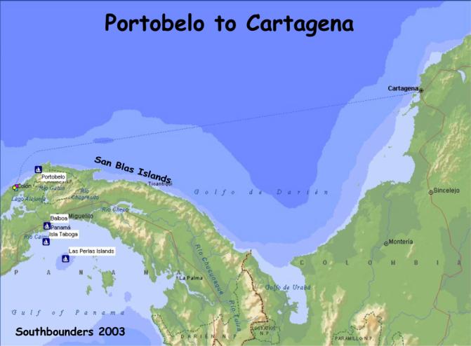
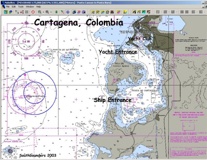
The trip to Cartagena
from Bonaire lasted 25 days total and some of the highlights included: a 1 1/2
hour lighting storm from Hell, our first 48 hour crossing without stopping, and
catching a 25 pound Blackfin Tuna. First
the storm...it started about 9:00pm. Of
course we don’t have storms in the day light!!!!! The whole sky lit up, with what we from Florida would call
‘heat lighting’. It was all
around us and would light up the sky about every 1 to 2 seconds. This was truly a beautiful sight until it got nasty.
There was another boat
ahead of us so we had about two minutes warning. Then all Hell broke loose. We did get the sails down this
time, but the rain hit so hard that
it made little bruises on your face
when you looked out to see other boats. We
had 35-40 knots of wind, driving rain, and then the cloud to ground lighting
started. The whole storm lasted
about 1 1/2 hours. Now remember
that 39 knots of wind is a tropical storm.
By comparison this one was a little milder than the one in the Dominican
Republic, but still not my favorite way to spend an evening. There was an upside to the trip.
We hooked a 6 foot Sailfish, but never got it to the boat.
This is our third Sailfish/Marlin that we have hooked since we have
started this trip (Dec
98). And the really good news is
that we did land a 34”, 25 pound Blackfin Tuna, enough to share with others
and have A LOT left over. Finally
we arrived in Cartagena October 25.
The best way I can sum
up Cartagena is it’s NOTHING like ‘Romancing the Stone”!!
I saw the movie and figured that all of Colombia was that way.
What a pleasant surprise to find out differently. The city is rich in
history, very clean and safe. We
did a two day tour through the old city visiting two forts, a convent, several
emerald factories and all three major museums.
We’re told that Cartagena is the major vacation spot for the ‘drug
lords’ and their families, which makes it very safe for us gringos.
There are three large
squares on beautiful cobblestone streets, that have dining under the stars in
the evenings. The weather here is
VERY hot during the day, but cools off in the evening. This is when the locals come out to enjoy the night air.
I was surprised at the many very tall condos on Boca Grande. This is a
large peninsula of land on the beach; it reminds me a lot of Miami Beach.
This is the ‘high rent’ district.
And of course Columbia is famous for their wonderful coffee.
This is served in very small cups and available from street vendors on
every corner all day. I often
wonder how they can drink the hot STRONG coffee all day. Another claim to fame for Columbia is their supply of
emeralds. You cannot go ten feet
without seeing an emerald shop. They
are not as inexpensive as one would expect.
Since there is such a grand history, they also sell pre-Columbian replica
earrngs. So I opted for 3-4 pairs
of the pre-columbian earings instead of one pair of emeralds.
I did get a pair of earrings with two very small green stones in them
that I was told were emeralds; however, they were only $3 so the chances are
pretty slim.
One side trip I made was
to Totumo Volcano. This is a mud
volcano about 50 kilometers out
side of Cartagena.
Well, needless to say the guys were not interested in going, so 4 women
got together for a ‘ladies day out’. Well
this was not you ordinary day out. We
hired a taxi to take us for the 1 hour ride to the volcano.
Here we changed into bathing suits and were escorted to the ‘MUD”. Now try to imagine your average size jacuzzi filled with mud.
Of course this is ‘therapeutic’ mud, but mud all the same.
It had the consistency and color of chocolate pudding.
And of course you just ‘jump’ in.
It is 500 meters deep but you just didn’t sink!!
All four of us were laughing so hard we were almost crying. Anyway, after
the laughter died down a little, 3
local men came to give us a massage. You
could
literally lay on top of
the mud without sinking! After
about 45 minutes of massage and playing in the mud, it was time to go to the
river and wash off. There were two
local woman there to help. Well
they just kept pouring water over us until most of the mud was gone.
Again the laughter could be heard for miles, because the
local woman (who spoke no English) would tug at your bathing suit until
you took it off! What a HOOT!! So ladies, what did you do on your last day out?
Well, even being ‘out
here in bugga bugga land’ we have managed to get on the WWW!
You
can see Soggy Paws and
some of the improvements that we
have made to her at www.marill.com, then to CSY sailboats, CSY Projects, and
finally SoggyPaws projects.
Actually the city of
Cartagena has been declared a neutral zone and although I would not travel
anywhere else inland in this country, we find the city as safe as any large city
can be. The U.S. Coast Guard has a
ship here and if there is any high level goings on happening, this is the place
for such meetings. We have met some
of the state department people and although the government will not come out and
say that this is a safe place for fear of retribution, they find it acceptable.
There are a few cruise liners who pull in here from time to time, not
Americans but others. But everyone
has their own comfort level. We
have quite a large cruising community from both the Atlantic and Pacific as well
as, from other parts of the world. I
am very glad we have had so much time to actually explore the old city with all
of its history, fine shops, and great inexpensive restaurants.
Cartagena – we loved it!
·
Two entrances:
Boca Grande & Boca Chica
·
we
did Boca Grande ànarrow & shallow over wall
from old fortification
·
continue
past statue of Virgin (middle of shallow bay)
·
Club
Nautico right side across from Navy base; anchor & dinghy in
·
check-in
w/ agent; we used Manfreid, paid $60
·
club
= $1.50/day for dinghy dock, water, restaurant, bar, laundry
·
Club
walking distance: bank, internet, big grocery store “Magali Paris”
·
taxis
are cheap & old city is beautiful!!
·
Parks,
Cathedrals, old mansions, Navy Museum, art galleries, Fort
·
and
great restaurants!! Favorite = San
Pedro across from church
·
also,
$2-3 lunches!
· safe and worth the trip!!
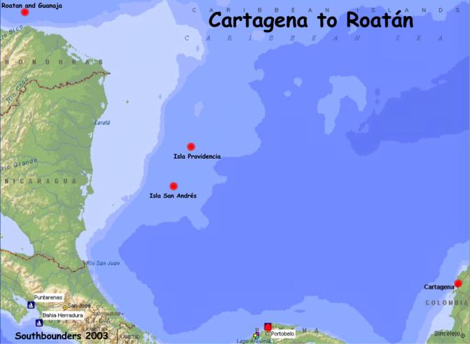
PANAMA TO ROATAN
May 1 - 29, 2001
Time for another
installment about life on Soggy Paws. After
five months in Panama we left Portabello, Panama, May 1, with a friend of
Dave’s, David Whall. From here on
out he will be called Whall, to keep the confusion down.
Imagine the response that I got when I called ‘Dave’.
Whall had agreed to this trip after some pressure from me to help ward
off pirates and from Dave to help locate shipwrecks that were indicated on some
of our charts. Also, this was the
first real trip for Radar, ship’s official cat and our new crew member. We left Portabello headed north at 6:30 am and arrived
at the Cayos Albuquerque Islands at 6:30 pm the next day. Whall being a seasoned sailor did fine and Dave
& I were OK too even though we had been in port for some time. However, Radar did not do so well. I think he was ready to jump ship. When I gave him a little Dramamine (about 2 crumbs from
a mashed pill) he was fine, and he slept the rest of the way.
The Albuquerque Islands
were two small islands in the middle of a fringing coral reef.
On the northern island was a Colombian Marine outpost with 9 soldiers and
on the southern island was a local fishing camp.
We spent an enjoyable 3 days there relaxing (me) while Dave and Whall
hunted for shipwrecks. None were
found despite three full days effort dragging each other behind the dinghy all
over the reef.
From there we went to
San Andres, another Colombian island. This
was the only heavily populated island that we stopped at. We took on fuel and
water, and of course that last fresh veggie run. Because the weather was going to turn bad, we had to leave
the next day, or be stuck there for longer then we wanted.
So
the next morning we were off to Low Cay just north of Providencia.
This was my personal favorite. The
water was a calm cobalt blue and you could see for miles. The boys found a real
shipwreck on a glassy calm day outside the reef, but alas no gold coins.
They had been looking for the Jack Law a shipwreck from the 1800’s
shown ‘just there’ on the chart, but found a huge modern freighter totally
demolished with a couple of tractors still on deck instead.
Over all the hunting and fishing were pretty good.
We caught a 12# tuna , a very large lobster, and a couple of conch.
So with the food that I got in Panama, and the fresh things we ate pretty
well. As we got a
little further to the north the anchorages were not as calm.
After a few days we left
for Quinto Sueño Bank a full day to the north.
There was no land, just miles of coral reefs out in the middle of the
ocean with narrow passages between them. It
is an area 25 by 8 miles virtually unexplored except by local fishermen.
There were four large shipwrecks aground on the outer eastern reef but
again no gold. We did find our fill
of conch; they were everywhere even crawling around under the boat! It was a beautiful area but we finally had to move on after
spending about a week working our way through the maze.
Our next destination was
Serranilla Bank, a 24 hour sail to the northeast. The main island, Beacon Island, was inhabited again
with nine Colombian marines who made us feel very safe in this part of the
Caribbean pirate world. The marines
treated us very well even greeting us with a fresh cocoanut drink when we landed
on their island.
It, like the
Albuquerques, was very neat and well kept.
Even the sand was freshly raked all over the island.
But the small island did not provide enough protection from the weather.
So after a few days we prepared to get underway for Swan Island. A half hour before we were to leave we were called on the VHF
radio by the Colombian Coast Guard vessel, which had just arrived.
They wanted to come and inspect the gringo boat.
While Whall, Radar and I were on the bow of the boat with an armed guard,
Dave showed the inspectors around the inside of the boat.
They were impressed to learn that we had two US Naval officers aboard
that outranked their captain! The
inspection took about an hour and was very professionally done.
Finally we were off for
a 48-hour trip to the northwest. The
night was uneventful except for one squall that we just missed.
With three people for watches we were all, including Radar, doing pretty
well the next morning. As the sun was coming up on a new day we saw a US Coast Guard
Cutter on the horizon. Well, Dave
decided to call them on the VHF radio and say hi, hoping to talk his way out of
having to stop for an inspection. When
they asked where we had come from Dave had to tell them Colombia, even though it
was only their offshore islands. Well,
this perked up their ears and they decided to send a boarding party over, but
the good news was we did not have to stop.
They came alongside and then aboard using a large RIB inflatable boat
while we sailed on with the autopilot. This
makes two Coast Guard boardings in 24 hours!!
The inspection including drug swipes and answering a long list of
questions took the better part of two hours.
They were all well mannered, very
nice and took great interest in what we were doing way out here.
At least this time Whall, Radar and I got to sit in the cockpit. We
arrived at Swan Island the next morning and finally found a protected anchorage
on the northwest coast. Dave
and Whall swam in with our ship’s papers to meet the five Honduran Navy
caretakers of the island. They got
a full tour and historical briefing (in Spanish) of the old Contra training
facilities that had all but been demolished by Hurricane Mitch in 1998.
There were very few trees or buildings left but they did
have lots of fresh water, 150 cows and a 6000 foot airfield on the
ilsland. We left Swan Island
after two days because we were running out of time.
From Swan Island we went
on to Guanaja in the Honduran Bay Islands.
This was
our first stop in the
Bay Islands. The main island of
Guanaja is a fairly large island (8 miles long x 2 miles wide), and is only
sparsely populated on the southern side along the very edge of the water front.
The bulk of the people live on a tiny island (300 yards across) one
quarter mile offshore because the sand fleas on the main island are so bad.
Now being from Florida I am use to these little bugs, but here in the Bay
Islands they RULE! This little
island was packed with people. Most
houses were built within 2 feet to each other and more houses were built out
over the water on stilts. I bet I
know where all the sewage goes. It
too had been demolished by Hurricane Mitch but was soon rebuilt.
The anchorage was very nice and calm after the past few rolly ones.
From Guanaja on 29 May
we went on to Roatan proper to drop Whall off to catch a plane home.
We stayed at the old CSY facility at Brick Bay on the southern coast.
I will start the next letter with our adventures in Roatan.
Until then, take
care...Stacy (author) , Dave (editor) & Radar (lucky participant)
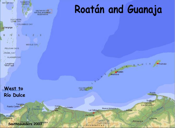
Information to be added
at a later date.
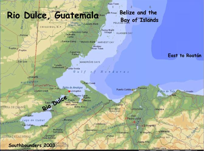
Guatemala Sept 2001 -
March 2002
Just can’t believe we
have been here so long!! We have
definitely had our adventures. When
we arrived a friend, Mike from Guam, came to see us to do 10 days of inland
touring. We started in Antiqua, a
beautiful old city high in the Guatemalan mountains with nearby volcanoes, well
kept churches, colorful buildings, and great shopping.
We stayed in a GREAT hotel here with big beautiful rooms and a fireplace.
Radar loved the room and so did I. There
was a marvelous courtyard-- I took 15 pictures before we ever left the hotel.
This was a special treat, as usually we stay in the lesser hotels.
From here we went by shuttle van to Panajachel and lake Atitlan. This place was like being at a Swiss lake in the Alps but
also with three large volcanoes. Panajachel was a great small town with lots of
shopping stalls in the street and of course the great view of the lake and
volcanoes. We found a neat little
outdoor restaurant very near the hotel appropriately named the Sunset Grill.
We went there every night, watched a spectacular sunset over the lake and
enjoyed a cold beer (or two). We
also took a boat trip on the lake to Santiago, a small typical Guatemalan
mountain town (this is the photo of the 3 men).
Also from Panajachel we toured the famous Chichicastenango Market.
We went on a Sunday, the best day to go.
There were lots of locally produced goods from all over the highlands of
Guatemala including beautiful hand carved masks, wonderful hand embroidery
material, and hand made leather belts and such. They were seriously lacking in earrings though.
But I found three great pair of earnings in Antigua, one of which was
green jade from a real jade factory showroom.
It was in Panajachel that we
saw the September 11 terrorist attack. Our
hearts went out to you all. We have been in places to follow the CNN news, and
we keep up as we can. We
then headed to the Copan ruins in Honduras through Antigua and Guatemala City.
Copan is an extraordinary example of the Mayan culture.
The stones have been preserved very carefully, and the grounds are
immaculate. It was a VERY long 6
hour bus ride to get back to the Rio Dulce.
Radar (our cat) went on this trip, but I will let him tell you his side
of the story later.
After we all settled
back onto the boat, Mike had a nice rest before heading home. Dave and Mike took
the dingy up two of the small rivers near the marina and saw lots of birds and
monkeys. After eating out in
restraints for the past 10 days, I took a lot of joy in my
cooking again.
In the early part of
December we had more guests, Chris & Serena from Michigan. During their
visit we took the boat out of the river to some nearby small Belizian islands,
the Sapodillas. It is always nice to have guests to show around.
We enjoyed some crystal blue water, snorkling and some beautiful sunsets.
The islands had pristine white beaches and great shelling.
The boys caught a huge reef crab that made a wonderful dinner.
Upon our return we spent some time in the river exploring small creeks,
Indian settlements and local restaurants. For their departure we took them back
out the river to the nearby major seaport of Barrios to start their journey back
home.
We of course spent the
holidays in the marina. Mike liked
Guatemala so much he came back for a relaxing Christmas visit.
He got to stay in his own bungalow on the marina grounds with the parrots
to wake him every morning! One day
we took Soggy Paws up river to nearby beautiful Lake Isabel with our friends
from CAMRYKA. It was a really nice
day and we were able to sail for several hours under spinnaker alone.
What a treat for Dave. For
Christmas all the cruisers had a pot luck with a turkey and all the trimmings.
Christmas eve we had a cocktail party with gifts for all and of course a
Super Bowl party at the end of January.
We are still in the Rio
Dulce and plan on leaving the end of March.
We have been to Guatemala city several times for shopping and doctors’
visits. Unfortunately, while we
have been here I (Stacy) developed a herniated disc in my lower back that needed
surgery. We were both very
pleased with the doctors and the medical care here.
The two hospitals were very
old, but the staff was well trained and the rooms were spotless.
The food was another story, as in all of Guatemala.
It was very ‘local’ and not to my gringo tastes.
Since we were going to
be here so long for me to heal after surgery, Dave decided to start a major
project, redesigning the refrigeration system and building a new top loading
freezer box. This has been on his
list for a while, and the price of material and labor to build the new exterior
box was very reasonable ($20 per day for two carpenters!).
So now we are within about two weeks of being done with the
refrigeration/freezer project. My back surgery has been a great success, I continue to get
better and stronger every day.
Again, sorry this was so
long in coming. I will try to do
better. We are heading back to
Roatan and then on to Belize, before returning to Guatemala in August.
We also have a change in long term plans-- we will be heading back to
Florida now in December. Stacy & Dave
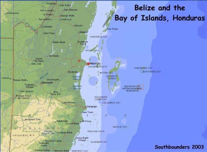
BELIZE
June 2002 - July 2002
We left Roatan in early
June with a friend of ours from Roatan. This was a real treat for me (Stacy).
It meant that I did not have to do the ‘blue jobs’ on the boat,
hauling up the anchor, pulling up the dinghy, raising the sails, etc.
So this made me a happy camper for a while.
I took us about 4 days to get to Belize and get checked in.
Then we were off to Glovers and Lighthouse atolls.
First it was Glovers Atoll for four days.
It was wonderful. The water
was very clear and there were many fish, especially along the wall which started
at about 40 feet. Both of the
atolls are Belizean National Parks so every thing is protected and in good
condition. Off Half Moon Cay at
Lighthouse there were wonderful cuts in the vertical wall with
lots of caves and visibility over 150 feet! On one dive we saw a turtle, a spotted eagle ray several very
large grouper and snapper and many conch. It
is nice to see so many large fish in one area.
While at Lighthouse we also dived at the famous Blue Hole about 10 miles
to the north. It was not so
spectacular but rather just a large deep hole in the reef with poor visibility
over the first 70 feet of depth. This made the dive rather eerie and dark.
There are small patches of reef all alone the way to and from the Blue
Hole that kept us on our toes navigating. These
were places that we could have looked for lobster and conch, however, the
fisherman had pretty well fished this area out.
However, we were able to find 4 lobster and 8 conch over the 2 weeks that
Brian was with us. After dropping
Brian off at Placencia, in southern Belize, so he could go back to Roatan, Dave
and I started heading north to Belize City for some major food provisioning, and
to pick up our next guest, Mike. As
always when Mike comes to visit we do a little inland traveling.
On our inland trip we went west into the mountains to San Ignacio.
We saw four Mayan ruins, including Caracol, one of the four best sights
in Central America. That was an all day trip into the jungle by four wheel drive
vehicle. We also did the famous
Belize Zoo. The Zoo is in a natural
setting and was really great. You
could get really close to the animals. Dave
and I also did a canoe trip into a wonderful cave with only a high powered light
to light our way. This was a
highlight for Dave. San Ignacio is
a small ‘backpackers’ town. Many
young people travel here ready for adventure.
From there we headed for the boat in Belize City to explore the reefs.
We took Mike to several islands including Rendezvous Cay and English Cay,
where Mike met another 79 year old who had made a 60 year career out of
lighthouse keeping.
We also got in some
exploring, snorkeling and sunset watching.
I think Mike was just pleased that there was a ‘Happy Hour’ each
night. We feasted on conch and
fresh fish from the reef. After
returning to Belize City to drop off Mike we picked up yet another set of
guests, KC and Roger Smith, long time friends of Dave’s.
After a day of provisioning we set off yet again to the atolls.
This time we went to Lighthouse and Turneffe atolls.
The diving was again spectacular at Half Moon Cay where we stayed for
several days. Here we visited the
modern shipwreck on the reef and the Booby bird rookery ashore.
Next we set off in search of a historical shipwreck off south west
Turneffe Atoll. The search was
compounded by several sets of inaccurate directions, including a declaration by
the local lodge owners that there were no shipwrecks in the area.
We finally found a very special shipwreck site with large anchors, chain,
hull fittings, a water box and many other sailing ship parts.
Roger, our onboard underwater archaeologist, put it as having come from
the last half of the 19th century. While
at Turneffe we did get a little shore leave.
KC and Roger treated all the crew of Soggy Paws to a BBQ dinner at
Turneffe Cay Lodge. What an
excellent night of shore leave that was!!!
The rum flowed, the food was great, and we all had a wild night of
dancing!! We were all a little slow to get out of our bunks the
following morning, but the diving fever persisted so off we went for another day
of diving. After about ten days at
sea we finally returned to Belize City. One
day Stacy took us on a tour of the old downtown cemetery at St James Church
where we saw graves dating back to 1800. The
following day we went tubing through a maze of caves and tunnels at a resort out
in the jungle.
After KC and Roger left,
Dave and I did a little food shopping and off we went to
MEXICO via Ambergris Cay
and Chinchorro bank. At Chinchorro
Bank we found the best historical shipwreck yet, aptly named Cuarenta Canones
(Forty Canons). Sure enough we
counted twenty nine and there were more buried under the coral and huge pile of
ballast stones. Here there was also
a very old 15 foot long anchor made for rope not modern chain.
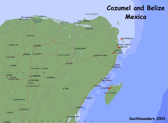
Information to be added
at a later date.
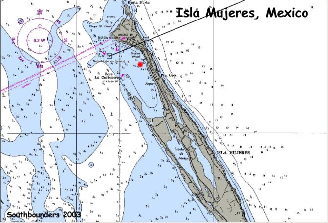
We did not spend much
time in Mexico, heading pretty much straight to Isla Mujeres.
Isla Mujeres is a VERY touristy town much like Key West.
Soon after we arrived Dave flew to California for the commissioning of
the USS McCampbell, a guided missile destroyer (ship) named after Dave’s
dad. His father was a famous
WW II fighter pilot, shooting down
34 Japanese airplanes.
This was a great honor for Dave and his son Chris who both attended with
about thirty other family members
I know in our last update we said that Alaska was our next adventure,
well this has changed.
After much discussion regarding the cost and time involved in
‘winterizing’ the boat, we decided to go back to plan A and do the Pacific
first. So, we are on our way back
to Marathon, Florida as you read this. We
will be in the Keys for about 6-8 months working on the boat and reprovisioning.
Then in about April 2003 we
plan to start heading down the western Caribbean to the Panama Canal, going
through to the Pacific side in
about December. Of course this is a
VERY loose plan, time will tell.
When we get back to
Marathon we will have completed our circumnavigation of the
Caribbean almost 5000
miles. It took only 3 years 8
months, which is 1 year 8 months longer than we planned. One thing you learn out here is that there is SO much to see
and so little time.
This will be our last
update letter for a while. I am
sure no one wants to hear about
the work we are doing on
the boat. However, while we are in
the states Chris, Dave’s son, is going to set up a McCampbell web site.
Stacy, Dave & Radar, Isla Mujeres, Mexico
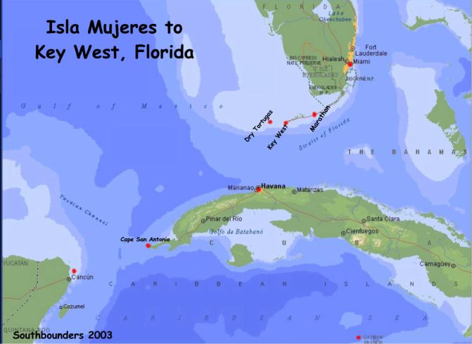
Information to be added
at a later date.
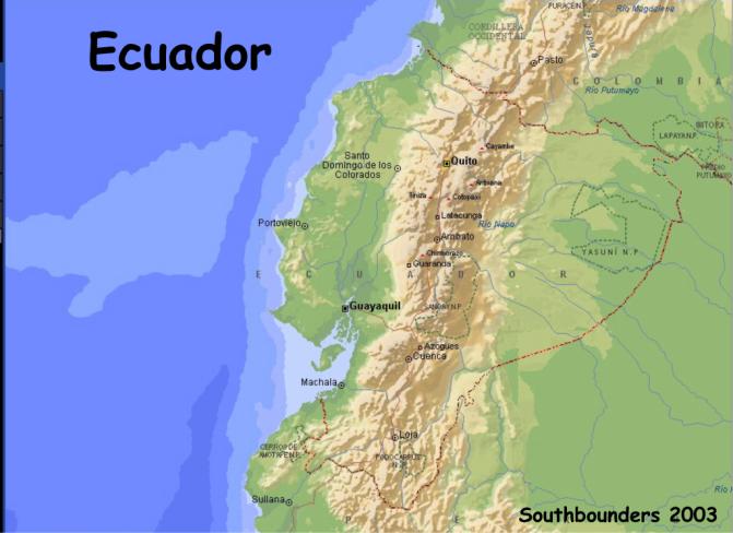
Ecuador
Coast
·
Manta
·
Puerto Lucia
Yacht Club, La Libertad near
Salinas .... great!!
www.puertolucia.com Manager is Galo Ortiz
Ecuador Inland ...
we toured the Sierra Regions
· La Libertad to Guayaquil (2 ½ hour bus ride)
·
Cuenca & Southern Highlands (Loja)
Ruins at Ingapirca, silver ‘filigree’ jewelry in Chordoleg &
Panama Hats made in Cuenca!
·
Riobamba – central Ecuador “all roads lead to Riobamba”
Chimborazo
(extinct volcano, highest mtn), Baños, Guamote, Quichua Villages
·
Latacunga,
Lasso (rose capital) &
Cotopaxi (volcano)
·
Quito – big city but easy to get around – go to Anthropology
Museum
·
Mitad de Mundo (Middle of the World) walk on equator!
·
Otavalo (huge market- crafts, leather & woven goods) &
Ibarra
· Hotels $7 to $25 (although there are upscale hotels too!)
· Distance buses comfortable & economical
· Recommend bus to Guayaquil & thru towns, then fly back from Quito
· Short trip inland = Cuenca; Longer = Cuenca à Quito or Otavalo
Recommend Lonely Planet “Ecuador & the Galapagos” book
May 4, 2001, Puerto Lucia Yacht Club, La Libertad,
Ecuador
Latitude 8*56.09N;
Longitude 79*33.28W
Just to let you know we
have arrived back in civilization. We spent a total of three nights at Isla de
la Plata, which we grew quite fond of despite the chilly air and water(Did we
mention the water temp was 67 degrees?) Then,
on Monday, the 30th we wrenched ourselves away, despite the promise of the first
sunny day and cruised 21 miles over to the mainland to check out an anchorage in
the Parque Machalilla called Los Frailles. We actually sailed a bit of the way
in the cool, clear sunny morning, before the wind died away, but it was joyous
to get some sunshine.
Los Frailles proved to
be a big open bay with a long sandy beach with dramatic rocky cliffs at each
end. Parque Machalilla protects the
very last bit of original tropical dry forest along the Ecuadorian coastline and
it appears to be a popular vacation beach.
Popular did not make it crowded. At
most we counted a couple of dozen people, all well spread out.
With the wind out of the SW, TII sat with her stern to the beach and her
bow bobbing nicely in the slight swell. Rationalized by lee shore and our
inherent laziness, plus the fact that water was unpleasantly discolored by red
tide, the decision was made just to hang out on the boat, do laundry and enjoy
the sunshine. We actually peeled off all those long layers and did a little
sunbathing! We got fried!
Several people swam out to talk to us, however.
The first was a group of three young Europeans -- Spain, Great Britain,
and Finland -- on holiday from their cultural exchange jobs in Quito; and then a
businessman from Quito. The next
day we did actually swim to the beach ourselves, and it did feel good to stretch
our legs. Interestingly, no one
spoke to us on the beach!
The next morning we
weighed anchor in the wee dark hours and motored nine hours, dodging several
fishing boats and nets along the way, to arrive midday into Puerto Lucia Yacht
Club, one of the most modern and new facilities we have seen since we have left
St. Thomas. There are two condo
towers, a hotel for members' guests, a fancy restaurant, big pool, gym, and
jacuzzi. The marina has its own yard (where Baker & Cindy are hauled out)
which is small but clean as a pin with solid tile/stone
paving and a 50 ton Travelift. Besides
slips on the floating docks, they have Med-Moor "slips" as well as
regular moorings. The Yacht Club
here charges $16,500.00 just for annual membership and then monthly fees are on
top of that. When you think about
the economy here, you realize that is a bloody fortune!
The club is five years old, and we're told they have 400 members.
However, in mid-week, off season, we yachties are the only souls in
sight.
Upon arrival we picked
up a mooring that was pointed out to us by one of the marina workers in a dingy
that lead us in around the breakwater. Friends Cindy and Baker on Lite N Up were
"on the hard" finishing their bottom job and waved and greeted us by
radio. The Club Manager appeared
and announced that he had ordered lunch for the four Americans to be delivered
in a few minutes to the yard. Some
spread--shrimp,fish, calamari, french fries, fried plantatins AND cold beer and
a bottle of white wine. All served
off the back of a golf cart with plates and glasses (no paper or plastic here),
cloth napkins and a bucket of ice to keep the beer and wine at the temp that you
know ALL boaters require of their beverages!!!! Baker and Cindy had talked about their other
"American" friends so much that he wanted to welcome us personally.
Clearly, they are working very hard to attract more transient boaters.
The hospitality sure worked on us, but I will have to say right now, we
did not ask for a membership application.
Later, Baker and I had
to make the "usual" trip to the hardware store for more paint and
parts for LITE n Up, while Gwen went with Cindy to another American's apt to do
laundry and emails. Baker
introduced me to a local bar on the corner (and if any of you speak to Cindy,
you should refrain from mentioning this as she thinks I'm a bad influence on
Baker!) of the main street in town. I
know, however, that it was not the first time Baker had been there (they have
been in the marina for 4 days) because the toothless, 4' 10" bartender
waved and smiled while grabbing a "grande" cerveza with two small
glasses and greeted us with "Senoir Baker, como esta?" I may be slow, but this old boy KNEW Baker and now he knows
ME! Anyway, we returned to the
marina (not too long after that-honest) and found the girls still gone so we did
the only thing we could do, have a beer and wait for them to return.
They did not return. Instead
we got a messsage to meet them at one of the local steak houses for dinner.
Great meal, little more costly than we are used to (at least for the last
few months), but it is the first time I have not been able to finish my
steak--can we say "MUY GRANDE". Returned
to the boat and slept like the dead......
This morning upon
making the coffee and trying to decide in which way we were going to relax for
the day, I poked my head outside to the cockpit and realized we were not in the
marina. We were not even close to
the marina! There was no wind to
speak of and no seas to speak of, so we did not realize the mooring had come
apart at the base and TII (and the mooring) had drifted out on the tide and
whatever little breeze there had been. Now
you have to understand that there is only one way into the marina.
It is surrounded by land and most of that land has big rocks.
On the way out of the marina we had to pass TWO channel markers and
another pretty good-sized power boat on a mooring right in the middle of the
channel. We are not sure how far out in the open we got as the tide was actually
coming back in when we discovered where we were.
At this point we were actually at least a half mile outside the
breakwater. Can we say "holy
shit!" Not long after we
realized where we were, the club's Security force (all 5 of them) appeared in
one of the club dinghies. They
didn't notice us "leaving" either; they just noticed us gone!
I finished making the coffee while they untied the mooring ball from the
bow of the boat, and we motored back in to the fuel dock. Hey, we were going to get fuel anyway.
About an hour or so
later the club manager shows up, shakes his head and looks to the heavens before
walking down the ramp to the 2 Captains sitting in the cockpit.
(Cindy had intercepted him at his truck, so if the crew had not explained
it to him, she sure as hell did). Well
guess what? We all got invited to our second "welcome" meal,
this time breakfast, and this time in the fancy restaurant, even as the marina
crew donned scuba gear and tried to figure out what went awry.
We heard later they couldn't even find our mooring in the mud, but we did
notice that they checked out all the other moorings. We must say that this is
the kind of response to a situation you like to see.
We have since fueled
the boat, and moved into a "Med moor" slip--2 lines to the shore from
the bow and 2 separate mooring lines to the stern, (note: that makes FOUR
attachment points!), plus water and power from shore. They could not do enough for us or fast enough for us.
We are thinking it might be a good time to ask for a "discount"
on one of those memberships!!!!! HA!
All in all, pretty damn
scary, when you stop to think about it. BUT
"no blood, no foul." There
is a reason we alway prefer to use our own ground tackle, but it is not an
option here. We may get a discount
on our total stay; we really haven't asked yet.
At the very least we should be able to use the fancy pool without the
$6.00/pp/day guest fees. It is a great place, and we will not worry about
leaving the boat for a few days (one of the Captains IS going to check the
underwater connections before we leave it). Lite N UP goes back in the water
this afternoon and the girls have researched our inland adventure.
Until then, Gwen and Don, The 2 “Married Captains” (Gwen and Don were
married in December of 2002)
April 29, 2001, Coastal
Ecuador
Leaving Bahia
The momentum of our
downhill return to Bahia from Quito carried over the next day to a determination
to pick up our anchor and get a move on. Cindy
and Baker on Lite'n Up had moved on during our absence to the southern port city
of Salinas for a much needed haulout, and HF radio contact with them urged us to
follow. It took a couple of days,
however, to get the boat ready to go again.
We had our frozen food to get back aboard, our zarpe (clearance paper) to
get, another couple of rounds of diesel by jerry jug to fill us back up, 150' of
anchor rode to pre-scrub of river grunge, and some fresh vegies to purchase,
clean and store. We had also
decided to be more prudent on our departure than we were in our arrival and to
use the local pilot. But with
amazing efficiency we got all this arranged, and our departure was set for high
tide - 0600 - Friday morning. The
prudent thing would have been to get to bed early for a good night sleep,
especially since we were still struggling with colds and other various
travelers' maladies. However, we
had been invited to a 31st birthday party our helper Marcelo was throwing for
himself Thursday night, and it was one of those invitations to which you can't
say no.
Until this party, I
would have described Marcelo as kind of an overgrown kid.
His day job is a tricycle driver. The
tricycles are a sort of rickshaw taxi with a front half of two wheels supporting
a bench and sometimes a canopy, powered by a bicycle back-half.
There are at least a hundred of these around town, many of which are
worked by kids (who probably ought to be in school!), and the cost of an average
ride is 25 cents. These make a lot of sense in the relatively flat town of
Bahia, but we saw tricycles elsewhere in Ecuador, including, incredibly, parts
of Quito, albeit less often. As you can imagine, they are real convenient for
schlepping stuff such as groceries, bottled water and jerry jugs of diesel as
well as bodies. Our association with Marcelo was a hand-me-down from Baker &
Cindy, who had used him for odd jobs on the boat during their year in Bahia, and
in addition to tricycle work, we had hired Marcelo (at $2 per night!) to sleep
aboard Tackless II while we were gone to Quito.
Apparently, when Baker
and Cindy left Bahia, they gave Marcelo a gift of $100.
This is a HUGE amount of money in Bahia, where loose change still matters
and just trying to break a $20 bill is a big deal.
It was a particularly big deal coming from Baker and Cindy who have made
a real campaign to keep visiting Americans from overspending.
Anyway, I think we saw the results of their largesse.
Marcelo came to collect
us at 8pm, already a late hour for the 2Cs.
Well, upon arrival at Marcelo's house, one of a string of shacks side by
side on a dirt lot kind of off the road in a field, it was clear that not only
was this was going to be a big event, but that we were way early.
A circle of twenty or so chairs framed the perimeter of the dirt yard,
lights had been strung overhead, and a big sound system with two guys in
attendance was cranking out music to the empty chairs.
Marcelo introduced us to his mother, a woman who never came out of the
house once through the course of the evening, and his sister, a very attractive
girl in her twenties.
As our eyes grew
accustomed to the shadows outside the lights, it became clear that there were
already clumps of neighbors and relatives sitting outside the party perimeter.
There were more introductions, but frankly the volume of the music made
the lack of a common language a fairly moot point.
We nodded and smiled a lot, and retreated to our chairs of honor where we
waited for things to get going.
If there is any single
impression that most stands out about that night, it is the transformation we
saw in Marcelo from trike kid to host. After
settling us into our chairs, he disappeared to change clothes.
We had never seen him in anything but a red T-shirt and shorts.
When he emerged in khakis and a long-sleeved cotton shirt, he looked like
a different man. As people began to
arrive, he suddenly appeared with trays full of plastic glasses of
"punch" which he personally passed among his guests.
Although every round was completely different from the one before, we are
quite sure there was nothing alcoholic in any of them.
And despite the thumping music, no one had started dancing.
It was probably about 9:30 now, and it was looking to be a very long
evening.
Then two things
happened. Marcelo appeared at Don's
elbow with two glasses of ice and a bottle of Cacique rum, "a gift,"
he said, "from a rich friend" (Cacique is about $3 a bottle.)
The second thing was that Marcelo asked me to dance.
The party at last was launched! Once
the dancing started it got going with a vengeance.
And people didn't just dance with their dates. Indeed, it seemed like
people rarely danced with their partners. Certainly
Marcelo didn't spend much time with his "novia," a shy, pretty girl
wearing a bug extermination T-shirt! This
meant, however, that the two gringos were not left to sit. As is usual in the tropics the tunes go on and on, and the
Latin flavor meant most of it was at high speed.
One slim young lady who happened to be quite tall for the local
population took quite a shine to Don, hauling him out for dance after dance.
Don believes it was due to his Cacique-inspired dancing abilities, but
personally, I think it was probably the first time she'd had a dance partner
taller than her! When they finally played a slow number, the 2Cs got a round
of applause for our romantic solo turn on the floor.
We tried to make a
graceful getaway several times in the course of the lengthening evening, but it
was absolutely not permitted. We
had to stay until "the torte." It is clear we were quite the guests of
honor, gringo stand-ins (we think) for Baker & Cindy.
At about 11:15, Marcelo began serving plates of rice pilaf.
This was both good news and bad news:
good news because it was very good and we'd consumed nothing but rum on
the rocks since lunchtime; bad news because it wasn't the "torte."
Don was quite intrigued that, over the course of the evening, absolutely
no one else assisted Marcelo in the hosting of his party, not counting of
course, whatever his mother was doing inside.
A far cry from back home where the B-day celebrant is the guest of honor
and rarely lifts a finger!
At 12:15 as the party
welled to upwards of fifty people, Marcelo's conscience (he did know we had an
early departure) must have finally caught up with him, and actually, I think, as
he was keeping us company in the Cacique, that something else was catching up
with him as well! He cast us free
with heartfelt emotions by delivering an advance piece of "torte" to
take away with us and providing his brother to escort us back to the dinghy.
We were hot, dusty,
soggy with dance sweat (we'd worn jeans and long-sleeve shirts against the
bugs), and more than a little buzzed. Meanwhile,
the tide had gone way out and the dinghy was high and dry with about ten feet of
ooze between it and the water! Delightful. We
still had not only to get back to the boat, but to get the dinghy broken down
and hoisted aboard for transit. It
was about 1:30 am when we sat down to our "torte" (a kind of coconut
cake) and a very tall glass of cold water.
We could still hear Marcelo's dance music thumping across the water!
To Isla de La Plata (Latitude: 01-16.00S; Longitude:
081-03.90W)
Tito, the pilot,
arrived promptly at 6:05am, a little anxious that our anchor was not already up
as he had instructed, but appeased when it came up quickly. Tito's real job, you see, is driving the ferry, and he had to
be back for the 6:45 run! He guided
us out around the point into conditions much calmer than the big swell we'd
arrived in. This may make it sound
like his presence was unnecessary, but actually, without the swell it was
impossible to tell where the sand bars were, so we were glad to have him.
On the other hand, had
we not had the pilot, we would probably not have left.
As you might guess, we were not feeling our best.
In fact, this captain was really feeling punk.
My highland cold was well entrenched in both my lungs and my two dozen
sinus cavities, and the night's sweaty dancing
had pulled out the final stops of my tourista.
The seas were flat and the wind non-existent, so, once we got clear of
the shoals, we put the throttle ahead and put the autopilot on (which perversely
had decided to work!) Our destination was Isla de La Plata, a small offshore
island that is part of the Parque Nacional Machalilla.
It is described as "a poor man's Galapagos," but it lured us
mostly as a remote anchorage away from civilization, of which by now we'd had
enough. There are no cruising
guides for this part of the world, and indeed not very many places anywhere
along the coast are suitable for stopping.
All the info we had about Isla de La Plata was a waypoint and word that
"the only anchorage is right in front of the only house."
Lite'n Up had had to pass it by as engine trouble got them there after
dark.
I expected to feel
better at sea, but I did not. I was just about to throw in the towel and retreat
to my bunk (now about a couple hours out) when we were approached by an open
boat with the familiar paint job of the Ecuadorian Armada!
For a moment I thought we had forgotten something back in Bahia, but it
quickly became clear this boat was from a different port.
There was an officer in white and a seaman in blue, but the fellow at the
tiller looked like any old fisherman, and indeed, the bilge was ankle deep in
fish! I guess patrolling duties
were light!
The Navy guys boarded
to check our papers which were all in order, we made the required chitchat,
which my Spanish was up to, and we gave them three cold sodas to take away.
They offered us some fish, which was kind but most unappetizing the way
we were feeling! Don sent me below
where I stayed most of the day, actually running a fever.
When I emerged to make him lunch, the wind had come up and he had gotten
the staysail up alone. We decided to raise the main before I went below again.
The wind, of course, was on the nose, forcing us to decide between
motoring dead on and tacking off. We had a big headland to round, and the
current was not in our favor. We
mixed the options back and forth, but no matter what we did, as the afternoon
progressed, it became increasingly clear that we too were not going to make it
before sunset.
Fortunately, I found a
fairly detailed chart of Isla de la Plata on our digital CD, and it showed an
approach free of obstacles. That
was the good news, because we could approach on radar without fear of submerged
rocks, and it would be a perfect opportunity to use our hot-shot night scope
which would show the anchorage as if in daylight. The bad news was that the anchoring shelf was quite
narrow. As the light dimmed (it had
been overcast all day), we took in sail and motored straight for it.
Imagine our joy when we made out a light on shore from the house!
Imagine our dismay, when we went for the night scope and could not find
it! Frantically, we ransacked every
nook and cranny in the boat with no joy! Suddenly,
the night approach did not seem like such a piece of cake.
However, with Don up on
the bow with the handheld radio and me at the helm with the radar on, we managed
to inch our way into anchoring depth and get the hook dropped.
Just as we needed it, Mother Nature helped by sucking away the day's
overcast, seemingly in the blink of any eye, leaving us with sparkling stars and
the crescent moon. The moment the
engine was off the air was filled with the slosh of surf against the beach and
boobies quacked in the cliffs. The anchorage was calm and empty but for us and one little
fishing boat (who kindly showed a light as we approached.)
The light ashore went off. We
ate our supper from cans and had a cool deep sleep.
We were very glad we didn't balk at stopping.
We still haven't found
the Night Scope, and are unwillingly coming to the belief that it has been
stolen. Nothing else seems to be
missing, though, and the likelihood of the Night Scope being a thief's choice
when so many other familiar and useful things are right out front make us
persist in resisting the idea. But,
we have been through EVERYTHING! It
would have to have occurred in the first couple of days in Bahia before the boat
was locked up, as we last used it the night before our entry there.
Meanwhile, we are
delighted with our anchorage. We've
been here two nights so far, recuperating from all our ailments.
The island is steep-to, with exposed rocky protrusions covered in guano
like a dusting of snow. The producers of the guano, a huge flock of blue-footed
boobies, circle and swirl feeding on schools of fish around the rocks.
The sea is settled and the water appears fairly clear.
The temperatures however are not equatorial.
Clearly we are under the influence of the cold Humboldt current that
comes up from Peru. The water temp
is a brisk 67 degrees, and the air temp about the same! We spend most of the day
in long pants, sleeves, and, yes, socks for warmth, violating one our cardinal
rules. Don has not rushed into the
water to check out the growth on the propeller, as is his usual thing. Sleeping is real good, however.
We are not totally
alone. As it is the weekend, tour
boats have come and gone with hikers and even (ye, gods) snorkelers and divers.
Local fisherman overnight here, and today a cooperative of four matching
boats came in to seine for bait fish. Last
night six sportfisherman came in for the night and partied until late.
But none of this activity has intruded on our peaceful contentment.
We are reading, writing, and eating normal American food.
We are, all in all, feeling much better, and we are in no hurry to move
on.
Ecuador Inland:
April 26, 2001
Inland Trip, Ecuador -
Quito & the Andean Highlands
The past week was the
first full-fledged dose of tourismo for the Two Captains since our junket to
Angel Falls in Venezuela last July. No
wonder people only vacation for a week at a time. It's work! Seriously,
though, we had a simply wonderful time. Ecuador
is a delightful country. "You find Ecuador tranquile, no?" the people
repeatedly ask us. Compared to its
neighbor Colombia, Ecuador is indeed tranquil….at least now that the furor
over the "dollarization" of their economy and some resultant price
increases has died down.
We left Bahia promptly
at 8 am Wednesday morning, and I rode most of the eight-hour , 10,000-foot
ascent to Quito with my face plastered to the window like a little kid.
Inland of Bahia the river edge has been cordoned off into ponds for
shrimp aquaculture. The Lonely Planet Guide blasts the destruction of the
mangrove environments this has wrought, but as catfish farmers we found it
pretty interesting. The next major
stage was a swampy plateau that brought to mind images of southeast Asia, and
indeed many of the cane houses were built on stilts above standing water that
may or may not have been planted in rice. Next
came a land of very steep convoluted hills covered in grassland and topped with
luck by a single palm tree. Then a
big agricultural plateau where we saw trucks and stands full of fruit and
vegetables. And finally the long
climb up into and over the Andes themselves. I don't know what was more amazing:
the mountains, the road, or the amount of heavy
commercial trucking - like large flatbed trucks of cement blocks, not to mention
all the busses - going both
ways…and passing!… on this serpentine, two-lane highway!
We went over the top in the clouds, and descended out of them again into
Ecuador's central valley, dubbed the Avenue of the Volcanoes, down which runs
the Pan American Highway.
Quito is really one of
the most amazing cities you will ever lay eyes on. Even though it is 2850 meters above sea level (about 9400
feet), huge mountains loom over it. Imagine
a bunch of woks crowded together, and you'll have an idea of the steep bowl-like
formations of its urban sprawl. And,
then, when that sprawl ends, picture orderly fields continuing on towards the
summits! Come to think of it, make
a perimeter of upside-down woks, and you'll have an idea of the immense flanks
of the surrounding volcanoes!
The bus station is in
Old Quito, which is packed especially tight into some gorges. Throughout it are
colonial buildings of great historical significance and charm.
However, old Quito is where most reports of pick-pocketing and mugging
take place, and our desire to avoid THAT negative experience, along with a
mutual indifference about historical buildings, made the bus station the only
part of old Quito we spent any time in. We
promptly grabbed a cab (which over-charged us handsomely before we discovered
they have two settings on their meters!) to Hostel Nassau, our B&C
recommended hostel, in a part of New Quito known informally as
"Gringolandia." Gringolandia is a seventy (or so) square-block area of
hostels, cosmopolitan restaurants (something other than beef and ceviche!),
T-shirt shops, tour agencies, and Internet cafés in which the population is
mostly Euro-American and younger than thirty!
One more thing about
Quito. The guides describe its high
mountain climate as perpetually spring-like.
Well, on a bright sunny day it's delightful, but overcast after a
thunderstorm as it was upon our arrival, it can get downright chill.
Brrrrr!
Fortunately, the next
morning dawned bright and sunny for our excursion to Mitad del Mundo. This is
the site where a French expedition in the late 18th century made the
measurements that determined the location of the Earth's equator, as well as the
fact that the Earth isn't exactly round, but flattened at the poles, and,
incidentally laid the foundations of the metric system.
It is also one of the few places in the world you can actually stand on
the equator, as much of the rest of Mother Earth's middle is lost in jungle or
ocean. The monument at Mitad del
Mundo takes you up in an elevator to a lookout that gives a good view of the
surrounding territory, the landscape of which is pretty much a scrubby desert.
Descent inside the monument winds down through exhibits of all the
various indigenous peoples - their customs, their history, their special crafts
and their distinctive dress (they prefer "indigenes" to
"Indians") - that make Ecuador so culturally diverse.
This would have been really interesting if more than four of the twenty
or thirty placards had been in English! A
side exhibit at the park displayed a current scientific/archaeological research
project being done that suggests that a very early pre-Inca people had located
the "Center of World" even more accurately than the French, about 800
yards away. This culture had built
temples on sites precisely equidistant from one another at angles of 23 ½
degrees, accurately lining up the declination of the winter and summer solstices
in the geometric star pattern that we see depicted over and over in traditional
weavings. The description of this
project and its findings was presented in a rapid-fire delivery by a
multi-lingual scholar who gave the same spiel all over to the next couple in
French! A piece of geographic
trivia this fellow pointed out was that Ecuador's highest volcano Chimborazo,
albeit slightly lower than Everest in height above sea-level is actually higher
when measured from the center of the Earth, since the Earth is fatter at the
Equator!
After Mitad del Mundo,
our taxi driver convinced us to let him show us La Virgin of Quito (our
initially well-bargained fare now going down the tubes!).
This is a monument in the fashion of the Statue of Liberty that was given
to Quito from Spain. The hollow figure sports a crown of stars, eagle's wings
(that give her an uncomfortable-looking hunched posture) and a chained
dragon…something Biblical. While
smaller than Ms Liberty, the Virgin is set high up on a hill above the Old City,
which gave us a fabulous 360-degree panorama of the entire Quito metropolitan
area from her observation platform. Would
that we'd dared to go back at night!
On Friday morning we
boarded another bus, this time for a two-hour trip east and north out of Quito.
Initially the landscape was more mountainous desert cut by deeply etched
gorges that the bus had to negotiate, but then, abruptly we came over a rise
into lush green farm land. The
central purpose to this excursion was the world-famous Saturday morning market
in Otavalo, but, based on Cindy & Baker's recommendations, we had decided to
stay in the nearby provincial capital of Ibarra.
Both these communities, along with a string of others, have grown up on
the lower flanks of the majestically Buddah-like extinct volcano Imbaburra
(4609m), which we learned later the Indians call the Sleeping Father.
We thought, as the bus pulled in to Ibarra, that we had made a mistake,
for it looked like just a crowded noisy town.
We grew more worried after B&C's recommended hostel was full.
We needn't have fretted. There
are probably several dozen hostels in Ibarra.
The one our cab driver took us to was the Hostel Madrid, where we were
welcomed in English by a young girl who'd spent a year as an au pair in North
Carolina. There we got a nice bright room (like our Quito hostel @$5
pp/nite!) only this one with a TV! We
got settled in, had a nice "almuerzo" in the downstairs restaurant
(the only restaurant we've been in with cloth napkins in lieu of the notably
puny paper napkings endemic to this country!) and then set out boldly on our
tourist "To Do" list. Unexpectedly
this was the beginning of a very special sequence of events.
First stop was the
village of Cotacachi. We have to
take a moment here to admit that the tourist "To Do" list for this
part of the world almost reads like a shopping list to a bunch of outlet malls.
The Indians of these highlands have specialized in a variety of crafts,
and these specialties seem to get concentrated in particular towns.
Therefore, to go to Cotacachi means you are going to look at leather
goods. Leather is not something
particularly practical for a couple of tropically-inclined yachties, and we
really are talking LEATHER: jackets, pants, belts, bags, briefcases, shoes, hats
(tried, but failed, to talk Don into a suede ball cap!) PLUS a whole range of
goods made with leather and woven or knit combinations, shawls, dresses, vests,
more bags….. It was endless! Still
we enjoyed wandering the streets, and Don did buy a horse-hair hatband for his
Panama hat plus a sweater jacket of llama wool (which he has worn non-stop
since!) while I bought a CD of Andean folk music.
Back in Ibarra, Don
felt he deserved a cold beer so we went looking for the El Encuentro, a bar
recommended in the Lonely Planet Guide. How
convenient that it turned out to be around the corner from our hostel.
The bar is in an inner courtyard, with rooms filled with antique ranching
equipment jigsawed in around the center. If
we haven't mentioned it before, the beer, called simply Pilsener, comes in
over-size 600ml bottles for between 65 cents and a $1@.
We were racking up a few when a group of young professionals arrived at
the table near us. One of their
party, hearing English, instantly came over and introduced himself. An English
teacher at the college, despite never having been to an English-speaking
country, Victor was keen on taking advantage of the chance to speak with us.
But, the cultural exchange was hardly one way.
To start with he invited us to a concert that night.
We went expecting something traditional, possibly Spanish, perhaps even
classical, but were astounded to get a performance of quite progressive original
New Age style music, as well as several modern dance performances. We parted
late with a pledge to come meet his family the next afternoon.
Saturday morning dawned
very early for the 2Cs and apparently too early for any Ibarra breakfast
establishment, so, coffee-less we boarded yet another bus (hopefully, you are
getting the very valid impression that public transportation is well-developed
in Ecuador) back to Otavalo. We
were rewarded by stumbling on the best breakfast we had anywhere in Ecuador at a
cheerful café a block from the market. Good
thing Don was fortified, because the market could have otherwise been
overwhelming. Hundreds of stalls
teeming with the handicrafts of local Indians fill a large open square and spill
onto adjoining side streets. The
Otalaveño Indians in particular are renowned for their weaving and there was
stall after stall of sweaters, hats, gloves, socks, bags, purses, ponchos,
blankets, hammocks, and wall hangings. There
were tiny painted boxes, dolls, bracelets, wood carvings, embroidered shirts,
music instruments and on and on and on! The
sheer volume of wool (from llamas as well as sheep) was awesome.
The people selling were as fascinating as what was being sold. The men wear white pants that stop mid-calf with ponchos on
top, a long braid down their back and the ubiquitous felt hat.
The women wear a cream wool full-length skirt with a second black or navy
skirt over it, embroidered blouses, shawls, a neck-full of gold beads and either
the felt hat or a elaborately folded headscarf.
These are just the Otalaveños; there were probably another dozen groups
represented each with their own distinctive dress.
Babies were everywhere, often
strapped to their back with a crisscross of sheeting, sometimes left to amuse
themselves in a pile of product, and quite often nursing openly! We tried very hard to peruse all the offerings before any
buying took place, but suffice it to say it to say we surely have at least one
of everything! And although we
tried hard to bargain, I'm sure we paid half-again what we needed to.
The good thing about this is the stuff is so cheap, everybody thinks they
did well by the deal.
Despite being laden
with our purchases we hopped off the bus short of home to take in the tourist
luncheon featured at the Hostelria Chorlavi.
This is a working Hacienda which doubles as an upscale resort for wealthy
Ecuadorians. There's a pool, tennis
court, and stables, and all the ground between the buildings is planted for
home-grown vegetables. On Saturdays
after the market they feature a traditional band and young folk dancers for
entertainment during lunch, served in the beautiful Spanish-style central
courtyard. Ironically, food-wise,
it was the meal we enjoyed the least of our trip, and I blame it for the
beginnings of a long bout of tourista.
We barely had time for
a short rest back at the room before we were collected by Victor and his friend
Anabel. The walk took us out of
crowded downtown through some very beautiful older parts of town.
Victor's home was relatively large and contemporary, and
six members of his family - (we should have anticipated this) were
present and dressed as for church! Now
you need to realize that Victor was the only truly bi-lingual person there. Anabel and Victor's brother Ivan spoke a smattering of
English, and we all know the extent of Don's Spanish (although he is making
great strides), but if I thought Victor was going to interpret I was mistaken.
Teacher that he is, he left me to present our story on my own.
You could feel the room swell with group support as I would reach for a
word or a particular verb conjugation! Victor's
Aunt Maria, in turn, tried to tell
us about a big church chorale concert she was involved in, and when it came
clear that we had just missed it that very morning, she gave us a personal
reprise of her performance. This
turned out to be a quite lengthy recitation of a poem celebrating, I think,
"my beloved countryside". It
was a very dramatic presentation, and one didn't have to understand a word to be
impressed! This was followed by a
round of sweet pink wine in tiny crystal glasses, which was then followed by
coffee with bread, biscuits and cheese at the dining room table.
Afterwards, after having heard all about our Otavalo shopping spree,
Victor's brother Ivan packed us into his car to take us to San Antonio de
Ibarra, a community famous for its wood carvings, predominately of
religious motifs. Only a few
shops were still open at this hour, and I hope we were not a grave
disappointment as we could not bring ourselves to buy one more thing.
All in all, it was one of the most special evenings we have yet enjoyed
in our travels.
The next day we packed
up to leave, but hopped off the bus one more time at the cross-road for the
community called Peguche. There was
some enticing talk about some Cascades in the guidebook, but our real motivation
for the extra effort was to get a special T-shirt Cindy was regretting not
buying from the Hostal Aya Huma, where she and Baker had gotten married.
It was a fortuitous stop, and, had we to do it all again, given that so
much of our great experience in Ibarra was entirely accidental, we would plan to
base ourselves here. As it was we
stayed one night only, but it is the first place we stayed that was not urban. The Hostal Aya Huma , (email: ayahuma@imbanet.net;
website (not working at the moment) is www.otavalo.com.ec/ayahuma .),
owned by a Dutch-Ecuadorian couple, is built straddling an abandoned railroad
track that is now a de facto road. The
original family building is now the restaurant/bar, which has a delightful
chalet-like atmosphere and fire-place, as well as sunny courtyard out front.
The rooms are built down the side of a wooded gorge filled with bird
chatter, at the base of which was a trickle of a stream and two hammocks.
It was a little pricier than our other hostels at $10pp/nite, but it was
a place you could happily spend a lot more time, as we later found out many
people do. We spent several hours
reading in hammocks before lunchtime, and then, in the afternoon took the walk
to the Cascades. The path led through park-like woodland (in fact it is a
park) to a right nice waterfall where many locals were enjoying the Sunday
afternoon. We branched off onto a
side path hoping to gain an overlook, which we found, but we had to negotiate a
couple of cows with whom we got into a shoving match.
The next couple up actually got chased…delusions of el toro!
In the evening we met
Ali, a young Dutch woman on her last night of a month-long stay. Ali had been
there so long she had acquired a pet piglet -Knorry - with wiry red hair, with
whom she was spending her last afternoon. Later,
we joined her to sip wine on a stone wall from which we could watch the
winding up of a typical Otalaveño Sunday --
the women and girls herding home the cows, the old men staggering home
under the influence of their once-a-week indulgence, the boys in American garb,
strutting their stuff -- all against a backdrop of a fantastic evening light
weaving through thick piles of cloud over
the beautiful valley. We moved the
wine inside to the fire place and a good dinner, which made a perfect cap to the
day before a deep quiet sleep under a pile of five Otavaleño blankets.
We woke to a parrot in
the branches outside our window. After
breakfast we took a walk through town, where weekday life was already under way.
Throughout the town we could hear, if not see,
the thunder of looms. We
caught a glimpse of an old man spinning wool at a wheel right out of Sleeping
Beauty. What we consider one our really special moments came went we stumbled
upon several young women making hammock yarn.
They were up a side road, across was strung wires at about 20'ft
intervals. Giant skeins of white
yarn were dumped in a big basket, out of which were drawn several strands which
ran up through a wire hanger attached to the eave of a house.
One girl walked the "U" of the strand over the wires some 300
feet up the road. The ends
were attached to an electric motor where we stood watching which then wound the
whole length into a single piece in about 60 seconds!
This was pegged over to the side until another length was wound, when the
two were spun together. Then one of
the girls would wind up the whole into a ball about the size of a basketball and
the process would repeat itself. Beneath
the winding yarns, children and dogs played happily in the dirt. This is not
tourist stuff. This is real,
everyday work.
We could have, and
would have, stayed on, except that we had had an email from our young Peace
Corps friend in Bahia relaying a message from our Port Captain that he was
unable to secure permission for us to sail on to the Galapagos and that we would
have to pursue it ourselves in Quito. Fearing
a bureaucratic snafu - and a totally illogical one at that, since every cruiser
we knew had sailed directly to the Galapagos from Panama without any special
permission - we hurried back to Quito. Needlessly,
as it turned out, as we determined that, despite the Port Captain's beliefs, no
permission was needed at all for us to go.
And, better luck, we found that out in one stop!
Still, once back in the big city, we found we were ready to go home.
A week away from the boat, without the boat being secure in at least a
marina, was a record for these two captains, and all the bus travel, chilly
climates, altitude, and foreign diet were starting to take their toll on these
tropical bodies.
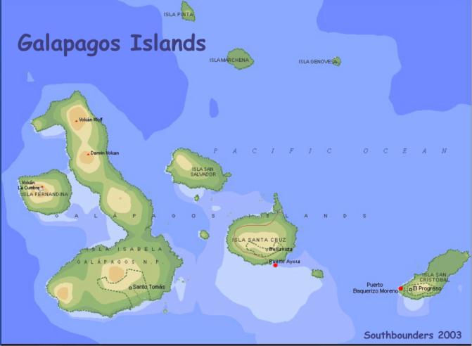
Galapagos Anchorages
:
1. After 4 easy sailing days from mainland Ecuador (Puerto Lucia Yacht Club in La Libertad near Salinas) we made landfall @ Wreck Bay on Isla San Cristóbal, the Easternmost of the Galapagos Islands
· Toured Galpagos Nat’l Park Interpretation Center (excellent!)
great intro, history & current efforts to preserve ecosystems & wildlife
· Go see large sea lion colony w/ hundreds of “Lobos Marinos” & black marine iguanas … some up to 3 feet long!
2. Santa Fe – 2nd anchorage (for afternoon then couple of nights later on)
· Quiet anchorage, north side of island; uninhabited (except sea lions)
· Good snorkeling & swimming with pups
3.0 Largest town and anchorage is Puerto Ayora on Isla Santa Cruz
· Harbor = Academy Bay
· Airport
· Rough anchorage due to swell (bow & stern anchors)
· no dinghys ahore (no tie up space), use water taxi
· cruise ships (20 passengers)
· Darwin Research Center ashore
· town had decent provisioning (produce) but limited marine supplies
4.0 Isla Isabela largest island in group
· Anchored at Puerto Villamil on southeast corner
· no major commerce, simple shops
· Giant Tortoise Breeding Center
· Darwin’s Finches in the woods
· Flamingoes at the lake
· Hiking & horseback riding around Sierra Negro volcano
· Close to anchorage (in the cove) checkout iguanas, penguins & white tip reef sharks Permits & Fees
· Conflicting
stories from other yachties
(ranged from needing to do it a year in advance to
“just go”)
· Fees
were variously reported as $100 per boat for five days to $200 per person per
day, plus a mandatory guide
· When
we left Ecuador mainland asked Port Captain for zarpe to Mexico with
interim stop in Galapagos. He said go to Quito for Galapagos permit, so we just
took the zarpe for Mexico and left … didn’t get a clear answer in the
Galapagos, either, despite questions to Nat’l park folks, so ended up just
being there – no park fees! If
you go, system may be different with more restrictions in terms of anchoring
locations and length of stay
Galapagos
“Best Wild life Adventures”:
· Horseback riding to Sierra Negra Volcano
· Swimming with reef sharks
· Snorkeling with juvenile sea lions
· Blue Footed Boobies
We spent 58 days in the
Galapagos, so had the opportunity to see lots.
Important
item that we were not
aware of before we arrived is that there is only
one bank in the
Galapagos which is located in Santa Cruz. They
only
accept Cirrus Network
or MasterCard at the ATM – no VISA. The
bank will
cash Traveler’s
cheques, but not personal. We had
to have money wired
from our bank in San
Diego which took 3 business days.
Get a guide book.
The best we found is called “Independent Traveler
Galapagos Handbook”,
about 8” x 5”, with a pic of an Iguana on the
cover.
Lots of good info.
Wreck
Bay, San Cristobal
1) First port we
checked in and had to pay $70 for Boat, $5 each for
Immigration and $100 ea
for Park Fee.
2) Would NOT enter in
the dark
3) Cheapest place to
buy T-shirts surprisingly
4) Two Internet Cafes
(good connections)
5) Dinghy beach just to
right of Port Captains office
6) Tourist stuff
a) Horseback ride to the
highlands to see the giant Tortoises in
their natural habitat,
then hike to the lake (El Mirador), then to the
giant lava tubes;
followed by truck ride to the Sea Lion Swimming Pool,
a fantastic place to
swim with them, plus you may see Marine Iguanas.
Interpretation Center
and hike is wonderful.
Academy
Bay, Santa Cruz
1) Port fee $4-6 and we
stayed over 30 days
2) Several stores for
provisions (thou you probably don’t need it).
3) “El Frio” has
great frozen meats, cheese, bagels, etc.
4) Several laundry
facilities – 1$ per kilo
5) Several great
restaurants – check out “Chocolates” – order a “Roasti”
and a piña
“Batidos”. Also, down towards
the Research Station on the
left is a place called
“Capricho” in funny letters. Veggie food, as well
as an exquisite pasta
with mushrooms. The kind of place
you would
expect to see the
“Mother Earth Newspaper” lying around.
6) No dinghy beach or
dock. Local water taxi the only way
ashore; cost
is 30 cents one way per
person.
7)
Water (8 cent a gallon) up by the fuel station.
Diesel is
$0.76/gallon, but they
will put 6 gallons in your five gallon
containers...Propane
available near the big welding shop.
8) Tourist stuff:
We splurged and took two boat trips:
1st Cruise
– 4 nights 5 days on the “Tropic Sun” (booked with Moonrise
Travel Agency) where we
ate well and we kept busy by hiking and
snorkeling both in the
morning and afternoon. Went to 6
islands and saw
lots of wildlife ...
from penguins to iguanas. Highly
recommend it if
you have the time and
budget ($500 a person).
2nd cruise
– One day cruise on “Santa Cruz II” to Isla Bartolome, where
we were fed breakfast
and a delicious fresh fish lunch, hike up 300+
steps to the top of the
island with a great view of the volcanic harbor,
and after the hike
snorkeling with a penguin, white-tip shark and other
fish.
Good photo op here. Cost
$60/ea.
Free stuff –
1. Bring water, snacks
and snorkeling gear and take water taxi about
10AM to Hotel El Delfin
and follow directions to Las Grietas and follow
lava rock trail until
you come to steep stairs that leads you to the
first grotto.
The swimming grottos are wonderful and worth the hike.
Fresh (not salt) water,
crystal clear
2. Charles Darwin
Center – On Mondays, Wednesdays and Fridays they feed
the tortoises, go about
7-8AM.
3.
Tortuga Bay – Great hike (go early it’s a hot hike) just follow the
signs in town that
point to Tortuga Bay on Charles Binford Ave.
You
will reach a ranger’s
headquarters where you will need to sign in.
Then
follow the stone path
that leads to a beautiful white baby powder beach.
Then
ENJOY the scenery! No shade, but a
beautiful beach
Villamil, Islabela
(our favorite anchorage)
1)
Port fee $4 and we got our Int’l Zarpe here (there is no Immigration
office here so need to
check out of country for Immigration at the
Police Office in
Academy Bay)
2)
Few stores for provisioning. One
Bakery. The best day to get
fresh veggies, fruit
& eggs is on Saturday afternoon after the trading
boat comes in.
3)
Some laundry services (Azul Ballena Hotel who also sells good water
for $0.20/gallon.
She’s a nice lady, if you see her say “hi” for us).
She also arranges tours
and does dinners by appointment.
4)
Good restaurants (the best pizza in Galapagos is at a restaurant
near the run down
looking park, just around the corner from the Port
Captains office, on the
beach. Part the weeds and walk up
to the
building, it always
looks deserted.)
5)
Tourist stuff:
a.
Hike to Wall of Tears (go in morning as it’s a long walk, also try
to catch a ride both
ways ... a lot of cruisers didn’t think it was
worth the walk.
It’s cruiser nickname is the Walk of Tears...
b. Flamingos in the
lagoon up the road as you go out of town. You
pass
by the lagoon on the
way the the wall of tears.
c. Horseback ride to
the cater – a must and can be arranged with one of
the hotels or if you
can find the person with the horses it will be
cheaper.
The more people you get to go the cheaper it is.
HOWEVER, I,
Rise (recommend no more
than 6-8 people unless you are expert horseback
riders, as the horses
tend to get really close to each other and I got
my legs smashed against
several horses several times luckily only
resulting in bruises (I
am a novice rider)
d.
Tortoise Reserve Center – We liked Charles Darwin center better as
the tortoises were
allowed to roam freely and you could get really close
to take pics.
Here they are enclosed and it’s hard to get good pics.
Well, we think that’s
all our brains can remember to tell you...
Oh, our course to the
Marquesas, we did not follow the rhumbline from
the start and headed
south due to wind and recommendation from Don on
Summer Passage (a
weather dude doing weather from Newport Beach-Ralph
(KK7PR) knows him).
It was a big mistake, as the second week we had to
jibe north, as we were
being set well below the rumbline. The
further
South, the more our
course would have had the wind directly aft, not our
best point of sail.
Oh well we are learning. We
also had to rig the
boat for wing-to-wing
in order to be able to sail downwind and keep on
course.
Note: be sure to use aft and fwd guys, and lock the pole in
solid, as the swell is
pretty awesome.
Well, will close are we
are tired. Last night we had nasty
squalls all
night and early hours
of the morning bring high wind (25-40K), lots of
rain and high seas that
slammed KOMFY around.
Take care and hopefully
we will see you somewhere in the South Pacific.
Jusqu’ à plus tard,
Mitch & Rise
Santa Cruz & San Cristobal, Galapagos Islands
Academy Bay, Santa Cruz
Latitude: 00-44.90S;
Longitude: 090-18.50W
We entered the
Galapagos Islands, under overcast and drizzly skies, May 16 at Puerto Ayora
(Academy Bay) on Isla Santa Cruz. Although
Santa Cruz is in the center of the archipelago, it was the port of entry
required by the peculiar red tape entangled around our “zarpe” from Salinas,
Ecuador. The good news was we
actually found the official we were supposed to find, and he indeed gave us the
time we’d been promised. Of
course, he subsequently said it would have been OK to enter at San Cristobal,
which is the geographically logical first stop.
Academy Bay is an
awkward anchorage. It faces South
which leaves it pretty wide open to the prevailing wind and swell. All the
boats, which include everything from fishing boats to large tour boats
(including, to my surprise the 148’ three-master Alta, which Captain Rob &
Barb ran in the Virgins!), do their best to crowd over to the protected side of
the anchorage, and stern anchors are required to keep all bows pointed into the
hefty swell. It is also one of
those places that totally addles my generally reliable internal GPS; the morning
after our arrival I would have sworn the sun was rising in the west! I never
could get it straight! Frankly, we
were just grateful to see the sun, for our first impressions of the Galapagos
were somewhat anticlimactic. On the
charts, the archipelago of islands is almost reminiscent of the Virgins, but in
fact the islands are spread out with some 40 miles of water between them, and in
the dismal grey they are pretty much out of sight of one another!
With the sunshine, the whole aspect changed.
The smooth volcanic slopes of Santa Cruz swept up greenly to the summit
of Cerro Crocker, only 864m high but still wrapped in mist.
It reminded us strongly of Nevis and St. Kitts.
Between post-passage
recuperation and a few more encounters with red tape, (we were required to have
a fumigation certificate and the inspector failed to show up two days in a
row!), we got a slow start on our sightseeing. The other problem we encountered
was that, although Puerto Ayora is the usual center of tour activity, the
airport there was closed for repairs. The result was most of the action had
packed up and moved over to Cristobal where the flights were then arriving!
This was a big handicap, because in the Galapagos, we are not permitted
to just sail around and anchor wherever we might wish.
Indeed, we are limited to just four anchorages.
Nor can you just climb in your dinghy and venture out.
Most access to “visitors sites” and island “landings” is
restricted to organized tours with licensed guides. As you might guess the same
restrictions apply to scuba diving. Most
cruisers who care bite the bullet and spend the $$ to partake of both day and
extended tours. Although it
requires leaving the boat, we were game. It
just wasn’t available!
Ashore on Santa Cruz,
however, there are several visitor sites we could walk to.
The first was the Charles Darwin Research Station.
This is a well-designed breeding center for the endanged Galapagos
Tortoises, of which there are eleven surviving subspecies (ten if you discount
Lonesome George, the lone remaining member of his!)
Visitors can wander the paths between naturally landscaped “corrals”
and see the tortoises from hatchlings on up to breeding adults.
One corral houses tortoises that were once pets, whose exact subspecies
is uncertain and which are therefore not included in the breeding program.
Visitors are allowed to get right down into this corral up close to these
tortoises. There was also a nice
exhibition on the natural history of the Galapagos, most of which was already
familiar to us from reading our various guidebooks. (Check out “The Galapagos
Islands” by Pierre Constant, available in Borders Bookstore; nice photos.)
Our second Santa Cruz
excursion was a 3km walk over to Tortuga Bay.
This was surprisingly nice with a “path” paved in tiles which led
through a jumbled terrain of rugged lava rocks where grow the arid-zone plants
of palos santos and cacti, including the quite intriguing Giant Opuntia Cactus
that actually has woody trunks! This
gave us our first exposure to the famously fearless Galapagos birdlife that so
struck Charles Darwin. Birds –
most notably the Galapagos mockingbird, the vermillion flycatcher and a cactus
finch – would allow us so close, that we repeatedly wondered who was checking
out whom. One little flycatcher
female was quite fascinated with Don’s ringlets as we each inched closer and
closer to one another. The path was
also a great place to make the acquaintance of various endemic geckos and lava
lizards. The white sand beach at
the end of the trail would have been the envy of any resort, yet the expanse was
unmarred as far as the eye could see and dotted only with a very few beachgoers
and surfers, most of whom we guessed to be young volunteers from the research
station.
Sunday we did our first
two dives in the Galapagos (indeed, in the Pacific!) at the justly famous Gordon
Rocks. We were a little anxious
about jumping right in at this “advanced-rated” site given that we hadn’t
dived since December and that we had a lot of new cold-water equipment to
inaugurate. Fortunately, the water was not as cold as we feared, nor were the
currents as stiff as advertised. Unfortunately,
visibility was also not as good as we would have liked.
Still, what a dive!...sharks, manta rays (coasting along like some sort
of stealth bomber!), eagle rays, turtles (big), moray eels, octopus, lobsters
and a ton of fish! There were so many big fish you couldn’t even pay attention
to the little ones, and all of them are different from their cousins in the
Caribbean! (Paul Humann, the man responsible for the great set of Caribbean reef
ID books we have always used on TII, also has a Galapagos fish book.) Coming up
a few minutes before the others on the first dive, we were bummed to find out we
missed the hammerhead sharks! On
the second dive, we hoped to add the hammerheads to the day’s list, but our
divemaster got disoriented and we spent half our time swimming hard in a huge
empty circle in midwater! The only
thing we saw during that stretch was a manta that cruised by curiously, clearly
asking the very question in all our minds:
“What the hell are you guys doing out here!” At the end, finally back at the rock, I lasted a few minutes
longer than Don and saw my first underwater sea lions scooting along the base of
a ravine, plus, just before reaching the surface, an ethereal school of 14
golden cownose rays (we don’t have anything like them in the Caribbean)!
Despite all this, the
real highlight of the day was our rest stop between the dives.
There, in a slot of water between the Plaza Islands,
we got to get in the water and snorkel with a whole tribe of sea lions.
While the fat old adults lounged around on boulders, the youngsters
happily played with us. Incredibly
COOL! Imagine going to a pet store
and standing in the middle of the big pen they keep the puppies in.
These guys just swam up to us and looked us right in the eye, then with a
flip of their front flippers they’d roll upside down under you and blow
bubbles or nip at the ends of our fins. A
couple had little rocks in their mouths which they would toss out like a ball
only to chase after them as they fell, grab them in their mouths again, swim to
the surface and then do it over. When
they swim, their rotund little bellies seem to twist independently of their
skin, so that it is hard to keep track of which way is up!
Monday morning at the
crack of dawn we hauled up our two anchors and motored/sailed 42 miles back east
to San Cristobal to rendezvous with Lite N Up, arriving that day from Salinas.
In the process we “caught” probably the biggest fish we have ever
hooked, about a 5 foot Wahoo(great eating).
Unfortunately, it was not a “real” catch, as the wiley critter broke
the line right at the stern of the boat by diving under the rudder.
We had two more good hits after that, but both times the line or lure
broke loose. So after losing about
$30.00 worth of equipment, we gave up on the fishing.
Wreck Bay, San
Cristobal
Latitude: 00-53.70S;
Longitude: 089-36.70W
Wreck Bay is a world
away from Academy Bay. We cruised
in and dropped the hook at the back of the pack in 30’ of clear water, and
sighed happily as the boat settled back quietly!
No more swell! What a concept, a protected anchorage!
Up ahead were fishing boats with the fat hulks of sea lions sprawled on
them, and several swam by Tackless II as if to greet us. This is kind of more
what we had imagined!
Not only had Lite N Up
arrived, but about four more cruising boats whose voices we had come to know on
the morning radio net. One was
Magic Four, a family of four from Australia, and another (we kid you not) Up
Chuck, four middle-aged guys from Manchester, England. In the way that is
peculiar in the cruising community, we suddenly found ourselves with an instant
social circle, which we have exercised in several establishments in town.
Also we had our young Peace Corps friend Amy, whom we’d met in Bahia.
She is now stationed here as a volunteer with the Charles Darwin
Foundation to develop small business projects with the local fishermen’s
wives. Only here a few weeks
herself, she has already made many connections, including one with the owner of
the local dive shop!
Which brought about
Wednesday’s dive trip to Kicker Rock (aka Leon Dormido or “Sleeping
Lion”.) Kicker Rock is one of the awesome volcanic “tuff” formations that
abound in the Galapagos. It sticks
up from the sea in a truly vertical thrust, and a split in the formation allows
boats to motor through it! It is
also rated as an excellent site to see hammerheads.
Nothing is easy,
however. Chalo’s Dive Tours, the
“operation” owned by Amy’s friend, has a broken air compressor.
Step in Tackless II Dive Charters. We’ll
fill the tanks and barter the service for our dive.
No problem. Don fills eight
shop tanks, and the next morning, off we go with a boatload that included John
from Magic Four and Frank, Hugh and Mike from Upchuck, plus Victor, our local
divemaster. I was very impressed with the speedy and smooth ride out to the dive
site, which the guidebook described as a three-hour boat trip.
The big 125hp outboard on the dive boat made it in a half hour!
We made two dives on the rock, essentially in the same place, and this
time we did indeed see our hammerheads! Quite
close in fact! Several of them! We also saw Galapagos shark, silver shark, huge turtles, an
eagle ray, several morays, another octopus, and a lobster along with several
billion reole wrasse and an equal number of urchins and sea biscuits lining the
near vertical wall! Even with four
Galapagos dives under our belts, the 2Cs are still stunned by the volume and
size of all these sea creatures. In
the Caribbean, we’d be thrilled with a ray or a shark a week!
For Hugh and Mike it was only their third or fourth dive since
certification! I think they’re
going to be ruined for life!
Remember I said,
nothing is easy? Trouble started on
the way back when the giant outboard developed a knock that grew worse and worse
(and we went slower and slower) until the engine up and quit!
The boys went back and tinkered to no avail.
No, shit, there we were, about eight miles away from home along a
completely undeveloped coast! Do we
have a radio? Surely, you jest.
It’s about 3 o’clock in the afternoon! We decided our best, most realistic
goal was to get to Los Lobos, home of a sea lion colony popular with tour boats.
The divers jumped in with mask and fins and we started towing and pushing
the dive boat toward our goal. There
were skeptics mind you, but in fact we made it to within a half mile before we
were rescued by a lobster boat and shortly after by a park service boat.
We all bought lobsters from the lobster boat.
Now, all those empty
tanks (14) came back to Tackless II, and Don and Victor got together yesterday
to fill them. The idea was that
we’d leave Victor to run the compressor while we went island touring, but the
day was full of small challenges. First,
the bleed valve (about the size of a nickel) on the fill hose flew off and
overboard, which resulted in a search of the bottom on scuba by Victor and me,
which, miraculously produced the piece. (Thank you St. Anthony!) Next problem,
the fill hose fails. This is the
NEW hose we had made a mere month ago in Quito.
Hmm. So Victor went off to
get the hose off their non-functioning compressor, which, of course turned out
to have different fittings. The
boys prevailed, BUT by then it’s 3:00 in the afternoon and they still had six
tanks to go! The pressure was on
because we had a big group trip planned for Friday with two boats, half to dive
again and half to snorkel, with a picnic at Los Lobos, the sea lion island.
We will take our OWN hand-held radio!
Well, the day trip went
without a hitch. What made it
particularly fun was the conglomeration of cruising boat crews that had been
getting to know one another. We had
six divers, and although it was the same dive site we had already done Wednesday
(Kicker Rock), the visibility was so much improved that it was like being in a
different place. Unfortunately, there was only one hammerhead, and Baker, on his
first dive in years, missed it. A
highlight for the 2Cs was a sea lion that passed us at 80 feet, heading down out
of sight like a torpedo! What was he after? Meanwhile a passle of eight or so
snorkelers putzed about the great rock on the surface.
After the dive, we moved both boats to Las Lobos to play with the sea
lion colony there during lunch, and then the divers made a shallow dive nearby,
the highlight of which were several sea lions who played with us at depth!
We also saw our first marine iguanas (they actually feed on algae
underwater!) and a lot of seabirds including blue-footed boobies, frigatebirds,
and a great blue heron. All boats
made it home without problem this time, and all in all a good time was had by
everyone. Don, however, insists it will be the last time we put ourselves in
such an “organizational” position. Retired
is retired.
We capped the day off
with a mass dinner at a really good restaurant in town called Albacora.
There 21 gringos filled the tables, and the owners produced a great meal
in a timely manner. Unfortunately, several of us are down with the revenge yet
again, which is keeping us close to home and putting a damper on today’s land
touring plans. Baker and Cindy and Amy have a friend flying in this afternoon
from Bahia for a week’s visit, and the 2Cs are getting ready to move on.
CRUISING PORTS: Florida
to California via Panamá, by Captains Pat and John Raines
SAILING DIRECTIONS
(ENROUTE), West Coasts of Mexico and Central America, 2000, Ninth Edition, Pub
153, US Government Printing Office
CHARLIE´S CHARTS of the
Western Coast of Mexico, by Charles E. Wood
MEXICO BOATING GUIDE
(Baja, Sea of Cortez, Pacific Mainland, Gulf Coast and Yucatán) by Captains Pat
and John Raines
MexWX, Mexico Weather
for Boaters, by Captain John E. Raines
THE FORGOTTEN MIDDLE, A
Cruisers Guide to the Pacific Coasts of Guatemala, El Salvador, Honduras and
Nicaragua by Roy and Carol Roberts
CHARLIE´s CHARTS of
Costa Rica, by Margo Wood
COVE HOPPING SOUTH to
Panamá, by J. A. Rogers
The PANAMA GUIDE, Second
Edition, A Cruising Guide to the Isthmus of Panama, by Nancy Schwalbe Zydler
& Tom Zydler
A Captain’s Guide to:
Transiting the Panamá Canal in a Small Vessel, by David W. Wilson
The Cruising Guide to
the Northwest Caribbean: The Yucatán Coast of Mexico, Belize, Guatemala,
Honduras, and the Bay Islands of Honduras, By Nigel Calder (currently out of
print)
HONDURAS and its BAY OF
ISLANDS by Captain Rick Rhodes
A Cruising Guide to
BELIZE and Mexico´s Caribbean Coast, including Guatemala´s Río Dulce, by
Freya Rauscher
CUBA, A Cruising Guide,
by Nigel Calder
The Concise Guide to
Caribbean Weather by David Jones
SOUTHBOUND CRUISERS
RESOURCE DIRECTORY 2002-2003, Guatemala, El Salvador, Honduras, Nicaragua, Costa
Rica, Panamá, by the Southbounders Group in Puerto Vallarta, Spring of 2000
THE PATH BETWEEN THE
SEAS, The Creation of the Panamá Canal Between 1870-1914, by David McCullough
CENTRAL AMERICA AND MEXICO PILOT (East Coast), Office of the US Navy, 1927